Taleggio, Lombardy
| Taleggio | |
|---|---|
| Comune | |
| Comune di Taleggio | |
 Taleggio | |
 Taleggio Location of Taleggio in Italy | |
| Coordinates: 45°54′N 9°34′E / 45.900°N 9.567°ECoordinates: 45°54′N 9°34′E / 45.900°N 9.567°E | |
| Country | Italy |
| Region | Lombardy |
| Province | Province of Bergamo (BG) |
| Frazioni | Olda, Peghera, Sottochiesa, Pizzino |
| Area | |
| • Total | 46.6 km2 (18.0 sq mi) |
| Elevation | 758 m (2,487 ft) |
| Population (Dec. 2004) | |
| • Total | 583 |
| • Density | 13/km2 (32/sq mi) |
| Demonym(s) | Taleggini |
| Time zone | UTC+1 (CET) |
| • Summer (DST) | UTC+2 (CEST) |
| Postal code | 24010 |
| Dialing code | 0345 |
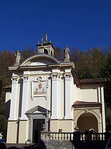
San pietro church
Taleggio (Bergamasque: Taècc) is a comune (municipality) in the Province of Bergamo in the Italian region of Lombardy, located about 60 kilometres (37 mi) northeast of Milan and about 25 kilometres (16 mi) northwest of Bergamo. As of 31 December 2004, it had a population of 583 and an area of 46.6 square kilometres (18.0 sq mi).[1]
The municipality of Taleggio contains the frazioni (subdivisions, mainly villages and hamlets) Olda, Peghera, Sottochiesa and Pizzino.
Taleggio borders the following municipalities: Camerata Cornello, Cassiglio, Fuipiano Valle Imagna, Gerosa, Moggio, San Giovanni Bianco, Vedeseta.
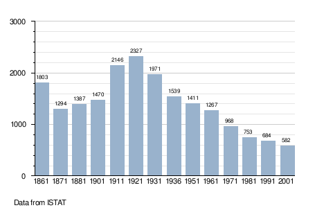
Demographic evolution
References

This article is issued from
Wikipedia.
The text is licensed under Creative Commons - Attribution - Sharealike.
Additional terms may apply for the media files.