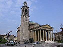
Ghisalba
| Ghisalba | |
|---|---|
| Comune | |
| Comune di Ghisalba | |
 | |
 Ghisalba Location of Ghisalba in Italy | |
| Coordinates: 45°36′N 9°45′E / 45.600°N 9.750°ECoordinates: 45°36′N 9°45′E / 45.600°N 9.750°E | |
| Country | Italy |
| Region | Lombardy |
| Province | Province of Bergamo (BG) |
| Area | |
| • Total | 10.2 km2 (3.9 sq mi) |
| Elevation | 170 m (560 ft) |
| Population (Dec. 2010) | |
| • Total | 5,967 |
| • Density | 590/km2 (1,500/sq mi) |
| Demonym(s) | Ghisalbesi |
| Time zone | UTC+1 (CET) |
| • Summer (DST) | UTC+2 (CEST) |
| Postal code | 24050 |
| Dialing code | 0363 |
Ghisalba is a comune (municipality) in the Province of Bergamo in the Italian region of Lombardy, located about 50 kilometres (31 mi) northeast of Milan and about 13 kilometres (8 mi) southeast of Bergamo. As of 31 December 2010, it had a population of 5,967 and an area of 10.2 square kilometres (3.9 sq mi).[1]
Ghisalba borders the following municipalities: Calcinate, Cavernago, Cologno al Serio, Martinengo, Mornico al Serio, Urgnano.
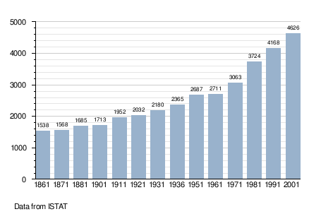
Demographics
References

| Authority control |
|---|
This article is issued from
Wikipedia.
The text is licensed under Creative Commons - Attribution - Sharealike.
Additional terms may apply for the media files.