Osio Sotto
| Osio Sotto | |
|---|---|
| Comune | |
| Comune di Osio Sotto | |
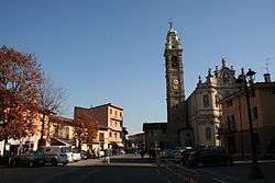 Pope John XXIII Square | |
 Osio Sotto Location of Osio Sotto in Italy | |
| Coordinates: 45°37′N 9°36′E / 45.617°N 9.600°ECoordinates: 45°37′N 9°36′E / 45.617°N 9.600°E | |
| Country | Italy |
| Region | Lombardy |
| Province | Province of Bergamo (BG) |
| Frazioni | Zingonia |
| Government | |
| • Mayor | Attilio Galbusera (Lega Nord) |
| Area | |
| • Total | 7.5 km2 (2.9 sq mi) |
| Elevation | 182 m (597 ft) |
| Population (Dec. 2004) | |
| • Total | 11,097 |
| • Density | 1,500/km2 (3,800/sq mi) |
| Demonym(s) | Osiensi |
| Time zone | UTC+1 (CET) |
| • Summer (DST) | UTC+2 (CEST) |
| Postal code | 24046 |
| Dialing code | 035 |
| Patron saint | San Zenone, San Donato |
| Saint day | 7 August |
| Website | http://www.comune.osiosotto.bg.it/ |
Osio Sotto (Bergamasque: Öss de Sóta) is a comune (municipality) in the Province of Bergamo in the Italian region of Lombardy, located about 40 kilometres (25 mi) northeast of Milan and about 11 kilometres (7 mi) southwest of Bergamo. As of 31 December 2004, it had a population of 11,097 and an area of 7.5 square kilometres (2.9 sq mi).[1]
Founded in Roman times,[2] the comune is currently the tenth municipality in the province of Bergamo by population, and the fourth of the southern Bergamo region.
Osio Sotto borders the following municipalities: Boltiere, Brembate, Filago, Levate, Osio Sopra, Verdellino.
Population history

References

| Authority control |
|---|
This article is issued from
Wikipedia.
The text is licensed under Creative Commons - Attribution - Sharealike.
Additional terms may apply for the media files.