Predore
| Predore | |
|---|---|
| Comune | |
| Comune di Predore | |
 | |
 Predore Location of Predore in Italy | |
| Coordinates: 45°41′N 10°1′E / 45.683°N 10.017°ECoordinates: 45°41′N 10°1′E / 45.683°N 10.017°E | |
| Country | Italy |
| Region | Lombardy |
| Province | Province of Bergamo (BG) |
| Area | |
| • Total | 11.6 km2 (4.5 sq mi) |
| Elevation | 190 m (620 ft) |
| Population (Dec. 2004) | |
| • Total | 1,837 |
| • Density | 160/km2 (410/sq mi) |
| Demonym(s) | Predoresi |
| Time zone | UTC+1 (CET) |
| • Summer (DST) | UTC+2 (CEST) |
| Postal code | 24060 |
| Dialing code | 035 |
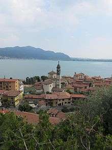
Predore (Bergamasque: Predùr) is a comune (municipality) in the Province of Bergamo in the Italian region of Lombardy, located about 70 kilometres (43 mi) northeast of Milan and about 25 kilometres (16 mi) east of Bergamo. As of 31 December 2004, it had a population of 1,837 and an area of 11.6 square kilometres (4.5 sq mi).[1]
Predore borders the following municipalities: Iseo, Sarnico, Tavernola Bergamasca, Viadanica, Vigolo.
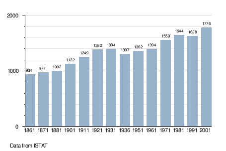
Demographic evolution
| Wikimedia Commons has media related to Predore. |
References
| Location | ||
|---|---|---|
| Settlements | ||
| Islands | ||
| Rivers |
| |
| Valleys | ||

This article is issued from
Wikipedia.
The text is licensed under Creative Commons - Attribution - Sharealike.
Additional terms may apply for the media files.