Fiorano al Serio
| Fiorano al Serio | |
|---|---|
| Comune | |
| Comune di Fiorano al Serio | |
 Fiorano al Serio | |
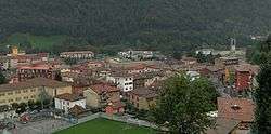
 Fiorano al Serio Location of Fiorano al Serio in Italy | |
| Coordinates: 45°48′N 9°50′E / 45.800°N 9.833°ECoordinates: 45°48′N 9°50′E / 45.800°N 9.833°E | |
| Country | Italy |
| Region | Lombardy |
| Province | Bergamo (BG) |
| Frazioni | San Fermo |
| Government | |
| • Mayor | Clara Poli |
| Area | |
| • Total | 1.1 km2 (0.4 sq mi) |
| Elevation | 396 m (1,299 ft) |
| Population (30 November 2016)[1] | |
| • Total | 3,004 |
| • Density | 2,700/km2 (7,100/sq mi) |
| Demonym(s) | Fioranesi |
| Time zone | UTC+1 (CET) |
| • Summer (DST) | UTC+2 (CEST) |
| Postal code | 24020 |
| Dialing code | 035 |
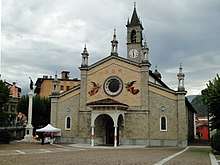
Parish church
Fiorano al Serio (Bergamasque: Fiorà) is a comune (municipality) in the Province of Bergamo in the Italian region of Lombardy, located about 60 kilometres (37 mi) northeast of Milan and about 15 kilometres (9 mi) northeast of Bergamo.
Fiorano al Serio borders the following municipalities: Casnigo, Cene, Gazzaniga, Vertova.
References

| Authority control |
|---|
This article is issued from
Wikipedia.
The text is licensed under Creative Commons - Attribution - Sharealike.
Additional terms may apply for the media files.