Caprino Bergamasco
| Caprino Bergamasco | |
|---|---|
| Comune | |
| Comune di Caprino Bergamasco | |
 Church | |
 Caprino Bergamasco Location of Caprino Bergamasco in Italy | |
| Coordinates: 45°45′N 9°29′E / 45.750°N 9.483°ECoordinates: 45°45′N 9°29′E / 45.750°N 9.483°E | |
| Country | Italy |
| Region | Lombardy |
| Province | Province of Bergamo (BG) |
| Frazioni | Sant'Antonio d'Adda, Celana, Opreno, Perlupario, Formorone, Ombria, (Prato) |
| Area | |
| • Total | 8.6 km2 (3.3 sq mi) |
| Elevation | 315 m (1,033 ft) |
| Population (Dec. 2004) | |
| • Total | 2,908 |
| • Density | 340/km2 (880/sq mi) |
| Demonym(s) | Caprinesi |
| Time zone | UTC+1 (CET) |
| • Summer (DST) | UTC+2 (CEST) |
| Postal code | 24030 |
| Dialing code | 035 |
| Website | Official website |
Caprino Bergamasco (Bergamasque: Cavrì) is a comune (municipality) in the Province of Bergamo in the Italian region of Lombardy, located about 40 kilometres (25 mi) northeast of Milan and about 15 kilometres (9 mi) northwest of Bergamo. As of 31 December 2004, it had a population of 2,908 and an area of 8.6 square kilometres (3.3 sq mi).[1]
The municipality of Caprino Bergamasco contains the frazioni (subdivisions, mainly villages and hamlets) Sant'Antonio d'Adda, Celana, Opreno, Perlupario, Formorone and Ombria.
Caprino Bergamasco borders the following municipalities: Cisano Bergamasco, Palazzago, Pontida, Roncola, Torre de' Busi.
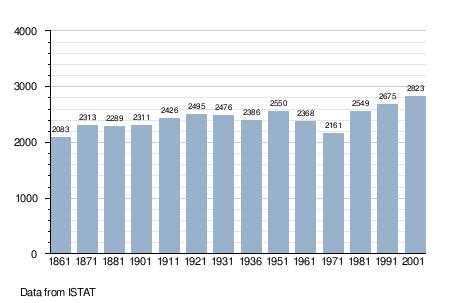
Demographic evolution
References
External links

| Authority control |
|---|
This article is issued from
Wikipedia.
The text is licensed under Creative Commons - Attribution - Sharealike.
Additional terms may apply for the media files.