Pedrengo
| Pedrengo | |
|---|---|
| Comune | |
| Comune di Pedrengo | |
 Pedrengo Location of Pedrengo in Italy | |
| Coordinates: 45°42′N 9°44′E / 45.700°N 9.733°ECoordinates: 45°42′N 9°44′E / 45.700°N 9.733°E | |
| Country | Italy |
| Region | Lombardy |
| Province | Province of Bergamo (BG) |
| Area | |
| • Total | 3.6 km2 (1.4 sq mi) |
| Elevation | 262 m (860 ft) |
| Population (Dec. 2004) | |
| • Total | 5,321 |
| • Density | 1,500/km2 (3,800/sq mi) |
| Demonym(s) | Pedrenghesi |
| Time zone | UTC+1 (CET) |
| • Summer (DST) | UTC+2 (CEST) |
| Postal code | 24066 |
| Dialing code | 035 |
| Patron saint | Saint Evasio |
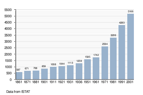
Pedrengo (Bergamasque: Pedrèngh) is a comune (municipality) in the Province of Bergamo in the Italian region of Lombardy, located about 50 kilometres (31 mi) northeast of Milan and about 5 kilometres (3 mi) east of Bergamo. As of 31 December 2004, it had a population of 5,321 and an area of 3.6 square kilometres (1.4 sq mi).[1]
Pedrengo borders the following municipalities: Albano Sant'Alessandro, Gorle, Scanzorosciate, Seriate, Torre de' Roveri.
Demographic evolution
References

This article is issued from
Wikipedia.
The text is licensed under Creative Commons - Attribution - Sharealike.
Additional terms may apply for the media files.