Bonate Sotto
| Bonate Sotto | ||
|---|---|---|
| Comune | ||
| Comune di Bonate Sotto | ||
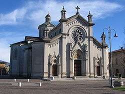 Parish church of the Holy Heart of Jesus. | ||
| ||
 Bonate Sotto Location of Bonate Sotto in Italy | ||
| Coordinates: 45°40′N 9°34′E / 45.667°N 9.567°ECoordinates: 45°40′N 9°34′E / 45.667°N 9.567°E | ||
| Country | Italy | |
| Region | Lombardy | |
| Province | Bergamo (BG) | |
| Government | ||
| • Mayor | Carlo Previtali | |
| Area | ||
| • Total | 6.3 km2 (2.4 sq mi) | |
| Elevation | 215 m (705 ft) | |
| Population (31 July 2017)[1] | ||
| • Total | 6,716 | |
| • Density | 1,100/km2 (2,800/sq mi) | |
| Demonym(s) | Bonatesi | |
| Time zone | UTC+1 (CET) | |
| • Summer (DST) | UTC+2 (CEST) | |
| Postal code | 24040 | |
| Dialing code | 035 | |
| Patron saint | St. Sebastian | |
| Saint day | 20 January | |
| Website | Official website | |

Bonate Sotto (Bergamasque: Bunàt Sóta) is a comune (municipality) in the Province of Bergamo in the Italian region of Lombardy, located about 40 kilometres (25 mi) northeast of Milan and about 9 kilometres (6 mi) southwest of Bergamo in the Isola bergamasca.
Outside the town are the remains of the Romanesque Basilica di Santa Giulia.
References
External links

This article is issued from
Wikipedia.
The text is licensed under Creative Commons - Attribution - Sharealike.
Additional terms may apply for the media files.