Averara
| Averara | |
|---|---|
| Comune | |
| Comune di Averara | |
 Averara | |
 Averara Location of Averara in Italy | |
| Coordinates: 45°59′N 9°38′E / 45.983°N 9.633°ECoordinates: 45°59′N 9°38′E / 45.983°N 9.633°E | |
| Country | Italy |
| Region | Lombardy |
| Province | Province of Bergamo (BG) |
| Area | |
| • Total | 10.58 km2 (4.08 sq mi) |
| Elevation | 650 m (2,130 ft) |
| Population (2011)[1] | |
| • Total | 184 |
| • Density | 17/km2 (45/sq mi) |
| Demonym(s) | Averatesi |
| Time zone | UTC+1 (CET) |
| • Summer (DST) | UTC+2 (CEST) |
| Postal code | 24010 |
| Dialing code | 0345 |
| Patron saint | San Pantaleone |
| Saint day | 27 July |
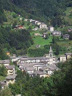
Averara (Bergamasque: Vréra) is a comune in the province of Bergamo, in Lombardy, Italy. It is one of the smallest and least populated comunes in the province of Bergamo.
It is surrounded by the following comuni: Bema, Albaredo per San Marco, Mezzoldo, Olmo al Brembo, Santa Brigida and Gerola Alta.
Coat of arms
The coat of arms of Averara shows two brick towers and a golden eagle.[2]
References
- ↑ ISTAT Archived March 3, 2016, at the Wayback Machine.
- ↑ araldicacivica.it
External links
- Business site with information on Averara in English
- Averara in Italian

This article is issued from
Wikipedia.
The text is licensed under Creative Commons - Attribution - Sharealike.
Additional terms may apply for the media files.