Udaipur State
| Udaipur State | |||||
| Former Princely State of India | |||||
| |||||
 | |||||
 | |||||
| History | |||||
| • | Established | 1818 | |||
| • | Independence of India | 1949 | |||
| Area | |||||
| • | 1941 | 33,517 km2 (12,941 sq mi) | |||
| Population | |||||
| • | 1941 | 1,566,910 | |||
| Density | 46.7 /km2 (121.1 /sq mi) | ||||
| • | 1901 | 1,018,805 | |||
| Today part of | India | ||||
| "Udaipur State (also called Mewar): History". The Imperial Gazetteer of India. 1909. pp. v. 24, p. 87. | |||||
The Udaipur State, also known as Mewar State,[1] was a princely state in northwestern India prior to the formation of the Indian Republic.
Geography
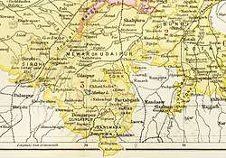
The geographical boundaries of Mewar have waxed and waned over the centuries,[2] but as of 1941, the area of the state was 34,110 square kilometres (approximately the size of present-day Netherlands).[3][4] From the treaty with the British in 1818 to its accession to the Republic of India in 1949, the boundaries of Udaipur state were as follows: the state was bounded on the north by the British district of Ajmer-Merwara; on the west by Jodhpur and Sirohi; on the southwest by Idar; on the south by Dungarpur, Banswara and Pratabgarh; on the east by Bundi and Kotah; and on the northeast by Jaipur.
History
Mewar was founded by Bappa Rawal, formerly a chieftain of the Mori king of Chittor, who acquired control of Chittor in c.728.[5]
For half a century prior to 1818, the armies of Holkar, Scindia, and Amir Khan had plundered Mewar, pauperising its ruler and people. As early as 1805, Maharana Bhim Singh of Mewar approached the British for assistance but the Treaty of 1803 with Scindia prevented the British from entertaining the request. But by 1817, the British too were anxious to have alliances with Rajput rulers and the Treaty of Friendship, Alliances and Unity was concluded between Mewar and East India Company (on behalf of Britain) on 13 January 1818.[2][6]
Under the treaty, the British Government agreed to protect the territory of Mewar, in return for which Mewar acknowledged British supremacy and agreed to abstain from political associations with other states and to pay one-fourth of its revenues as tribute for 5 years, and three-eight in perpetuity.[6] The British authorities granted the ruler of Udaipur a 19 gun salute.
A constitution for Udaipur State was adopted on May 23, 1947.[7] The last ruler of Udaipur State signed the accession to Independent India on 7 April 1949.[8]
Maharanas
The rulers of Udaipur held the title of maharana. Their regnal dates were:[9]
- Bhim Singh (1778-1828)
- Jawan Singh (1828-1838)
- Sardar Singh (1838-1842)
- Swarup Singh (1842-1861)
- Shambhu Singh (1861-1874)
- Sajjan Singh (1874-1884)
- Fateh Singh (1884-1930)
- Bhupal Singh (1930-1956)
- Bhagwat Singh (1956-accession to Republic of India)
- Mahendra Singh Mewar
Bhagwat Singh died on 2 November 1984. He has two sons, Mahendra Singh and Arvind Singh. Before his death, he founded a trust named the Maharana Mewar Foundation and tasked younger son Arvind to look after it. Arvind lives in Udaipur's City Palace.
British Residents and Political Agents
Political Agents employed by the East India Company to oversee their affairs in the state included James Tod, who held the office from March 1818 to June 1822. The post of British Resident that superseded this position was twice held by Alan Holme (1908 – 1911 and 1916 – 1919).
Administrative structure
At the time of the 1901 census, the state was divided into 17 administrative sub-divisions - 11 zilas and 6 parganas, the difference between a zila and pargana being that the latter was larger and broken up into further subdivisions.[10] Further, there were 28 principal jagirs and 2 bhumats.[11] Each zila was administered by a hakim, a state official, supported at each tehsil (a zila sub-division) by an assistant hakim.[12]
Land tenure
The principal forms of land tenure in the state were jagir, bhum, sasan, and khalsa. Jagirs were grants of land made in recognition service of a civil or political nature. Jagirdars, the holders of jagir, usually paid a fixed annual tribute called chhatund on an annual basis, and nazarana on the succession of a new Maharana. On the death of a jagirdar, the jagir reverted to the Maharana until the late jagirdar's successor was recognized by the Maharana. Those holding bhum tenures paid a small tribute or nominal quit-rent (bhum barar), and were liable to be called on for local service. Sasan (also known as muafi) holders were not liable for payments to the Maharana but taxes were sometimes recovered from them. Khalsa (crown lands) holders were cultivators who were undisturbed in their possession as long as they continued to pay land revenue.[13] As of 1912, 38% of the land revenue of the State was from khalsa land, the rest from other forms of tenure.[14]
See also
References
- ↑ Agarwal, B.D. (1979). Rajasthan District Gazetteers: Udaipur. Jaipur: Government of Rajasthan. p. 230.
- 1 2 Gupta, R.K.; Bakshi, S.R., eds. (2008). Studies in Indian History: Rajasthan Through the Ages Vol. 5. New Delhi: Sarup & Sons. p. 64. ISBN 978-81-7625-841-8.
- ↑ "The World Factbook: Netherlands". Central Intelligence Agency. Retrieved 22 December 2017.
- ↑ Dashora, Yamunalal (1942). Census of Mewar, 1941. Alwar: Sharma Bros.
- ↑ Vaidya, C.V. (1924). History Of Mediaeval Hindu India. II. Poona: The Oriental Book Supplying Agency. p. 75.
- 1 2 Aitchison, C.U. (1909). A Collection of Treaties, Engagements and Sanads Relating to India and Neighbouring Countries Vol. III. Calcutta: Superintendent Government Printing, India. pp. 10–32.
- ↑ Darda, D.S. From Feudalism to Democracy. New Delhi: S. Chand & Co. (Pvt.) Ltd.
- ↑ Princely States of India
- ↑ The Rajputs of Rajputana: a glimpse of medieval Rajasthan by M. S. Naravane ISBN 81-7648-118-1
- ↑ Agarwal, B.D. (1979). Rajasthan District Gazetteers: Udaipur. Jaipur: Government of Rajasthan. p. 2.
- ↑ Imperial Gazetteer of India : Provincial Series Rajputana. Calcutta: Superintendent of Government Printing. 1908. pp. 106–168.
- ↑ Ojha, Gaurishankar Hirachand (1999). उदयपुर राज्य का इतिहास. Jodhpur: Rajasthani Granthagar. pp. 15–16.
- ↑ Erskine, K.D. (1908). Rajputana Gazeteers, Vol II-A (The Mewar Residency). Ajmer: Scottish Mission Industries Co. Ltd. pp. 71–72.
- ↑ Administration Report of the Mewar State for the Year 1910-11. Ajmer: Scottish Mission Industries Co., Ltd. 1911. p. 1.