Mewar
| Historical Region of Western India Mewar | |
| Location | Southern Rajasthan |
| Language | Mewari |
| Dynasties | Moris (up to AD 734) Guhilas (Guhilots) (734–1303), Sisodias (1326–1952) |
| Historical capitals | Nagda, Chittaurgarh, and Udaipur |
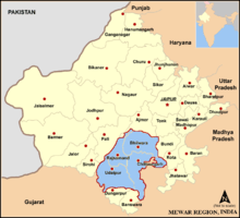
Mewar or Mewāḍ is a region of south-central Rajasthan state in western India. It includes the present-day districts of Bhilwara, Chittorgarh, Rajsamand, Udaipur, Pirawa Tehsil of Jhalawar District of Rajasthan, Neemuch and Mandsaur of Madhya Pradesh and some parts of Gujarat.
For centuries, the region was ruled by Rajputs. The princely state of Udaipur emerged as an administrative unit during the period of British East India Company governance in India-ruled and remained until the end of the British Raj era.
The Mewar region lies between the Aravali Range to the northwest, Ajmer to the north, Gujarat and the Vagad region of Rajasthan to the south, the Malwa region of Madhya Pradesh state to the southeast and the Hadoti region of Rajasthan to the east.
Etymology
The word "Mewar" is vernacular form of "Medapata" (IAST: Medapāṭa), the ancient name of the region. The earliest epigraph that mentions the word "Medapata" is a 996-997 CE (1053 VS) inscription discovered at Hathundi (Bijapur). The word "pata" or "pataka" refers to an administrative unit. According to the historian G. C. Raychaudhuri, Medapata was named after the Meda tribe, which has been mentioned in Varāhamihira's Brihat-Samhita.[1] The 1460 Kumbhalgarh inscription associates the Medas with Vardhana-giri (modern Badnor in Mewar region).[2] Historian Sashi Bhusan Chaudhuri associates the ancient Medas with the modern Mer people.[3]
The 1285 CE (1342 VS) Mount Abu (Achaleshwar) inscription of the Guhila king Samarasimha provides the following etymology while describing the military conquests of his ancestor Bappa Rawal (Bappaka): "This country which was, in battle, totally submerged in the dripping fat (medas) of wicked people by Bappaka bears the name of Śrī Medapāṭa." Historian Anil Chandra Banerjee dismisses this as a "poetic fancy".[4]
Geography
The northern and eastern portions of Mewar are made up of an elevated plateau while the western and southern portions were rocky and hilly with dense forests.[5] The watershed divide between drainage of the Bay of Bengal and drainage of the Gulf of Khambhat runs almost through the centre of Mewar.[6] The northern and eastern part of Mewar is a gently sloping plain, drained by the Bedach and Banas River and its tributaries, which empty northwest into the Chambal River, a tributary of the Yamuna River. The southern and western part of the region is hilly, and marks the divide between the Banas and its tributaries and the headwaters of the Sabarmati and Mahi rivers and their tributaries, which drain south into the Gulf of Khambhat through Gujarat state. The Aravalli Range, which forms the northwestern boundary of the region, is composed mostly of sedimentary rocks, like marble and Kota Stone, which has traditionally been an important construction material.
The region is part of the Kathiawar-Gir dry deciduous forests' ecoregion. Protected areas include the Jaisamand Wildlife Sanctuary, the Kumbhalgarh Wildlife Sanctuary, the Bassi Wildlife Sanctuary and the Sita Mata Wildlife Sanctuary.
Mewar has a tropical climate. Rainfall averages 660 mm/year, and is generally higher in the southwest and lower in the northeast of the region. Over 90% of the rain typically falls in the period of June to September every year, during the southwest monsoon.
History
The state of Mewar was founded around 530; later it would also, and ultimately predominantly, called Udaipur after the name of the capital. In 1568, Emperor Akbar conquered Chittorgarh, the capital of Mewar. In 1576, Maharana Pratap, the ruler of Mewar, was defeated at the Battle of Haldighati and Gogunda, Udaipur and Kumbalgarh were conquered. However through guerilla warfare, Mahrana Pratap recaptured Western Mewar.[7] In 1615, Amar Singh accepted Mughal suzerainty over Mewar.[8] It remained in Mughal hands thereof for about 150 years. When Udaipur State joined the Indian Union in 1949 it had been ruled by the Rajputs of Mori, Guhilot and Sisodia dynasties for over 1,400 years.[9][10] Chittaurgarh was the capital of Sisodia clans of Rajputs of Mewar.
Founding
Bapa Rawal is considered the founder of the Mewar state.[11] While his predecessors had enjoyed control over limited areas in the hilly regions in the west and southwest of Mewar, Bappa was the first ruler to expand the state close to its later boundaries.[11] Bappa, who had his capital at Nagda (19 kilometres north of Udaipur), extended his possessions to the east by ousting Man Singh of the Mori (Maurya) clan from Chittor in 734 AD.[11] He took on the title of 'Rawal.'[11]
Treaty with East India Company
For half a century prior to 1818, the armies of Holkar, Scindia, and Amir Khan had plundered Mewar, pauperising its ruler and people.[12] As early as 1805, Maharana Bhim Singh of Mewar approached the British for assistance but the Treaty of 1803 with Scindia prevented the British from entertaining the request.[12] But by 1817, the British too were anxious to have alliances with Rajput rulers and the Treaty of Friendship, Alliances and Unity was concluded between Mewar and East India Company (on behalf of Britain) on January 13, 1818.[12][13]
Under the treaty, the British Government agreed to protect the territory of Mewar, in return for which Mewar acknowledged British supremacy and agreed to abstain from political associations with other states and to pay one-fourth of its revenues as tribute for 5 years, and three-eight in perpetuity.[13] The British authorities granted the ruler of Udaipur a 19 gun salute.[14]
Accession to Republic of India
The last ruler of Udaipur Kingdom signed the accession to Independent India on 7 April 1949.[15]
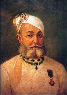
Ruling dynasties and personages of Mewar
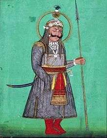
Sisodia Dynasty
Rana Laksha of the Sisodia Rajput clan with all his 10 sons had rallied in defense of Chittor but in vain. The Sardars decided that it was time to safeguard the royal lineage. There is mention of only two sons of Rana Laksha by name, Ari Singh and Ajay Singh. Ari Singh I had a son named Hammir Singh I who was taken by his uncle Ajay to Kelwara for safety. After the defeat of Mewar at Chittor by Alauddin Khalji, in which Rana Laksha and his son Ari Singh perished, the people began to rally behind Ajay who pursued a guerrilla campaign until he too died in the 1320s. The Sardars now picked Hamir Singh I as head of the Sisodia clan and rightful heir to the throne of Mewar. He married the daughter of Maldeo of Jalore, who now governed Chittor for the Delhi Sultanate. He overthrew his father-in-law and reclaimed his ancestral homeland.[16]
| Sisodia Dynasty at Chittor | |||||||||||||||||||||||||||||||||||||||||||||||||||
| |||||||||||||||||||||||||||||||||||||||||||||||||||
| Sisodia Rajput Dynasty at Udaipur | ||||||||||||||||||||||||||||||||||||||||||||||||||||||||||||||||||||||||||||||||||||||||||||||||||||
| ||||||||||||||||||||||||||||||||||||||||||||||||||||||||||||||||||||||||||||||||||||||||||||||||||||
Chief Ministers, British Residents and Political Agents
| Dewans |
 Rai Pannalal Mehta (Dewan, from 1878 – September 1894)
|
| British Political Agents |
|
| British Residents in Mewar and Southern Rajputana States |
|
| Political agents in Mewar and Southern Rajputana States |
|
Jagirdars (nobles)
The nobles of Mewar were numerous and powerful, enjoying rights and privileges that were unusual in other princely states.[17] Mewar nobles exhibited "few of the marks of vassalage observable at other courts" and "take rank above the heir-apparent - a custom unprecedented in India."[17]
During the rule of Umra Singh II (1700-1716), the nobles were arranged into three ranks[17]:
- 'Solah' (Hindi: सोलह): The highest rank consisting of 16 nobles
- 'Battis' (Hindi: बत्तीस): The second rank consisting of 32 nobles
- 'Gol' (Hindi: गोल): Rest of the nobles
Over time, the number in each class has increased.[17]
| 1st Class Jagirdars | |||||||||||||||||||||||||||||||||||||||||||||||||||||||||||||||
|
The 1st Class Jagirdars, the 1st 16 Umraos (no order of precedence), seated on the either side of the Maharana. Ideally, those to right were seated at right angles to the Gaadi and were called Badi Ole and those to the left, not to feel any inferior, were seated parallel to the Gaadi and were called Munda-barobur (parallel to the face of the Maharana). The visiting dignitaries/guests and some of the relatives of Maharana and main Purohits were seated in front of Maharana’s Gaadi, Saamey-ki-baithak.
|
| 2nd Class Sardars - Bateesa | |
|
There were 32 Jagirdars after 1939. Prior to AD 1935 just four. They were later called Bada Bateesaa. |
|
|
1. Boheda (Shaktawat) |
| Category 3 of Mewad Sardars |
|
1. Aarjya (Ajarya) (Chavda) |
| Bhumiya Sardars of Mewad |
|
1. Jawaas (Chauhan) |
Administrative structure
At the time of the 1901 census, the state was divided into 17 administrative sub-divisions - 11 zilas and 6 parganas, the difference between a zila and pargana being that the latter was larger and broken up into further subdivisions.[18] Further, there were 28 principal jagirs and 2 bhumats.[19] Each zila was administered by a hakim, a state official, supported at each tehsil (a zila sub-division) by an assistant hakim.[20]
Land tenure in Mewar State
The principal forms of land tenure in the state were jagir, bhum, sasan, and khalsa.[21] Jagirs were grants of land made in recognition service of a civil or political nature. Jagirdars, the holders of jagir, usually paid a fixed annual tribute called chhatund on an annual basis, and nazarana on the succession of a new Maharana. On the death of a jagirdar, the jagir reverted to the Maharana until the late jagirdar's successor was recognized by the Maharana. Those holding bhum tenures paid a small tribute or nominal quit-rent (bhum barar), and were liable to be called on for local service. Sasan (also known as muafi) holders were not liable for payments to the Maharana but taxes were sometimes recovered from them. Khalsa (crown lands) holders were cultivators who were undisturbed in their possession as long as they continued to pay land revenue.[21] As of 1912, 38% of the land revenue of the State was from khalsa land, the rest from other forms of tenure.[22]
Economy
The economy of the Mewar region relies primarily on tourism, the marble and stone industry, mining, handicrafts, zinc smelters, cement and tyre factories, as well as agriculture. Major crops include maize, groundnut, soybean, wheat, and mustard. Opium is also grown in the adjoining regions of the southeast (Pratapgarh and Nimbahera). Fishery also thrives in the region's various lakes, supported by a government fisheries department.
Tourism
- The massive Chittorgarh hilltop fort is one of the main tourist attractions of Mewar. The fort is a depiction of Rajput culture and values. It stands on a 2.4 square kilometre site on a 180 m high hill that rises rapidly from the plains below. The fort was sacked thrice by a stronger enemy. The first sacking occurred in 1303 by Alauddin Khalji. In 1535 Bahadur Shah of Gujarat besieged the fort, causing the women to commit Jauhar. In 1568 the Mughal emperor Akbar captured the fort. This war between the Mewar and Mughal turned the fort to rubble. Akbar's dream to conquer the whole of Mewar was never fulfilled but Chittorgarh was not resettled by the royal family again.
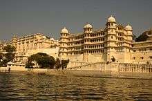
- Udaipur, also known as the city of lakes, is a world-famous and a very popular tourist destination with its grand palaces, lakes, temples, gardens and narrow lanes.
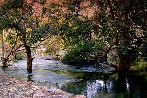
- The Lake Palace is a palace inaugurated in 1746, completely made of marble, and situated in the middle of Lake Pichola. In recent years Lake Pichola has experienced drought conditions.
- UnthalaGarh
- Jaisamand Lake
- Udaisagar lake
- Fatehsagar lake
- Shilpgram, a village northwest of Udaipur, hosts a crafts fair every year, which is one of the largest in India.
- Eklingji, a temple dedicated to Lord Shiva, the ruling deity of Mewar.
- Keshariaji, a temple of Rishabhdev.
- Nathdwara, a temple of Lord Shrinathji, one of the most important pilgrimage sites of India.
- Haldighati, a mountain pass in Rajsamand district that hosted the battle between Rana Pratap Singh and the Mughal emperor Akbar.
- Kumbhalgarh, a 15th-century fortress, built by Rana Kumbha, with 36 kilometres of walls. Over 360 temples are within the fort. It also has a wildlife sanctuary.
- Charbhuja Temple, dedicated to Lord Vishnu.
- Rajsamand, a huge lake near Rajsamand city, from which the city derives its name.
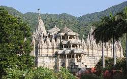
- The Ranakpur village is home to one of the most important Jain temples, which escaped the Mughal emperor Aurangzeb's efforts to destroy Hindu and Jain temples, because it is hidden in a geographically difficult terrain.
See also
References
- ↑ G. C. Raychaudhuri (1940). History of Mewar from the Earliest Times to 1303 A.D. Kanjilal, Calcutta University Press. p. 8. OCLC 917040797.
- ↑ Dineschandra Sircar (1963). The Guhilas of Kiṣkindhā. Sanskrit College. p. 38. OCLC 161579.
- ↑ Sashi Bhusan Chaudhuri (1955). Ethnic settlements in ancient India. Calcutta: General. p. 26. OCLC 2278769.
- ↑ Anil Chandra Banerjee (1958). Medieval studies. A. Mukherjee & Co. p. 19. OCLC 254699661.
- ↑ Imperial Gazetteer of India : Provincial Series Rajputana. Calcutta: Superintendent of Government Printing. 1908. pp. 106–168.
- ↑ Gupta, R.K.; Bakshi, S.R., eds. (2008). Studies in Indian History: Rajasthan Through the Ages Vol. 5. New Delhi: Sarup & Sons. pp. 64–77. ISBN 978-81-7625-841-8.
- ↑ Chandra 2005, pp. 121–122.
- ↑ Pant 2012, p. 129.
- ↑ Princely States of India
- ↑ "Udaipur State (also called Mewar): History". The Imperial Gazetteer of India. 1909. pp. v. 24, p. 87.
- 1 2 3 4 Erskine, K.D. (1908). A Gazetteer of the Udaipur State with a Chapter on the Bhils and Some Statistical Tables. Ajmer: Scottish Mission Industries Co. Ltd.
- 1 2 3
- 1 2 Aitchison, C.U. (1909). A Collection of Treaties, Engagements and Sanads Relating to India and Neighbouring Countries Vol. III. Calcutta: Superintendent Government Printing, India. pp. 10–32.
- ↑ Udaipur (Mewar) Princely State (19 gun salute).
- ↑ Princely States of India
- 1 2 3 The Rajputs of Rajputana: a glimpse of medieval Rajasthan by M. S. Naravane ISBN 81-7648-118-1
- 1 2 3 4 Chiefs and Leading Families in Rajputana (2nd ed.). Calcutta: Office of the Superintendent of Government Printing. 1908.
- ↑ Agarwal, B.D. (1979). Rajasthan District Gazetteers: Udaipur. Jaipur: Government of Rajasthan. p. 2.
- ↑ Imperial Gazetteer of India : Provincial Series Rajputana. Calcutta: Superintendent of Government Printing. 1908. pp. 106–168.
- ↑ Ojha, Gaurishankar Hirachand (1999). उदयपुर राज्य का इतिहास. Jodhpur: Rajasthani Granthagar. pp. 15–16.
- 1 2 Erskine, K.D. (1908). Rajputana Gazetteers, Vol II-A (The Mewar Residency). Ajmer: Scottish Mission Industries Co. Ltd. pp. 71–72.
- ↑ Administration Report of the Mewar State for the Year 1910-11. Ajmer: Scottish Mission Industries Co., Ltd. 1911. p. 1.
Further reading
- Mewar through the ages, by D. L. Paliwal. Sahitya Sansthan, Rajasthan Vidyapeeth, 1970
- The Kingdom of Mewar: great struggles and glory of the world's oldest ruling dynasty, by Irmgard Meininger. D.K. Printworld, 2000. ISBN 81-246-0144-5.
- Costumes of the rulers of Mewar: with patterns and construction techniques, by Pushpa Rani Mathur. Abhinav Publications, 1994. ISBN 81-7017-293-4.
| Outline |  | ||||||||||||||
|---|---|---|---|---|---|---|---|---|---|---|---|---|---|---|---|
| Governance | |||||||||||||||
| Divisions and districts |
| ||||||||||||||
| Major cities | |||||||||||||||
| Related templates |
| ||||||||||||||