Shanhaiguan District
| Shanhaiguan 山海关区 | |
|---|---|
| District | |
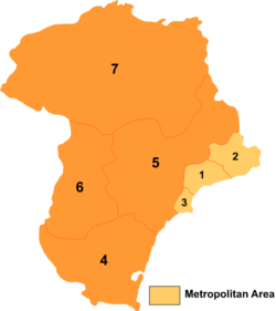 Shanhaiguan is the area marked "2" on this map | |
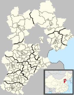 Shanhaiguan Location in Hebei | |
| Coordinates: 39°58′44″N 119°46′32″E / 39.97889°N 119.77556°ECoordinates: 39°58′44″N 119°46′32″E / 39.97889°N 119.77556°E | |
| Country | People's Republic of China |
| Province | Hebei |
| Prefecture-level city | Qinhuangdao |
| Seat | Nanguan Subdistrict |
| Area | |
| • Total | 192 km2 (74 sq mi) |
| Elevation | 2 m (7 ft) |
| Population (2003) | |
| • Total | 140,000 |
| • Density | 730/km2 (1,900/sq mi) |
| Time zone | UTC+8 (China Standard) |
| Postal code | 066200 |
| Area code(s) | 0335 |
| Website | Shanhaiguan.gov.cn |
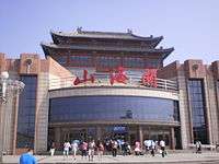
Shanhaiguan station
Shanhaiguan District (simplified Chinese: 山海关区; traditional Chinese: 山海關區; pinyin: Shānhǎiguān Qū), formerly Shan-hai-kwan or Shan-hai-kuan, is a district of the city of Qinhuangdao, Hebei Province, China, named after the pass of the Great Wall within the district, Shanhai Pass. It is located 15 kilometres (9.3 mi) east of the city centre.
Administrative divisions
There are five subdistricts, three towns, and one township, Bohai Township (渤海乡), in the district.[1]
Climate
The climate is hot-summer humid continental with a monsoon pattern (Dwa:).
| Climate data for Shanhaiguan, China | |||||||||||||
|---|---|---|---|---|---|---|---|---|---|---|---|---|---|
| Month | Jan | Feb | Mar | Apr | May | Jun | Jul | Aug | Sep | Oct | Nov | Dec | Year |
| Average high °C (°F) | 1.6 (34.9) |
4.0 (39.2) |
11.3 (52.3) |
19.8 (67.6) |
26.3 (79.3) |
30.0 (86) |
30.7 (87.3) |
30.0 (86) |
26.0 (78.8) |
19.6 (67.3) |
10.6 (51.1) |
3.5 (38.3) |
17.8 (64) |
| Average low °C (°F) | −7.7 (18.1) |
−5.5 (22.1) |
1.0 (33.8) |
8.5 (47.3) |
14.8 (58.6) |
19.6 (67.3) |
22.7 (72.9) |
22.1 (71.8) |
16.6 (61.9) |
9.6 (49.3) |
1.5 (34.7) |
−5.1 (22.8) |
8.2 (46.7) |
| Average precipitation mm (inches) | 3 (0.12) |
6 (0.24) |
9 (0.35) |
24 (0.94) |
34 (1.34) |
68 (2.68) |
185 (7.28) |
155 (6.1) |
42 (1.65) |
21 (0.83) |
10 (0.39) |
4 (0.16) |
561 (22.08) |
| Average precipitation days (≥ 1) | 2 | 3 | 3 | 5 | 6 | 8 | 13 | 11 | 6 | 5 | 4 | 2 | 68 |
| Source: Hong Kong Observatory (1961-1990)[2] | |||||||||||||
Subdistricts
- Nanguan Subdistrict (南关街道)
- Dongjie Subdistrict (东街街道)
- Xijie Subdistrict (西街街道)
- Lunan Subdistrict (路南街道)
- Chuanchang Road Subdistrict (船厂路街道)
Towns
- Diyiguan (第一关镇)
- Shihe (石河镇)
- Mengjiang (孟姜镇)
References
- ↑ 山海关区行政区划 (in Chinese)
- ↑ "Climatological Information (Reference) for Shanhaiguan, China". Hong Kong Observatory. Retrieved July 4, 2011.
External links
This article is issued from
Wikipedia.
The text is licensed under Creative Commons - Attribution - Sharealike.
Additional terms may apply for the media files.