List of National Parks of Canada

Canada's National Parks are protected areas under the Canada National Parks Act, owned by the Government of Canada and administered for the benefit, education, and enjoyment of the people of Canada and its future generations.[1] National parks are administered by Parks Canada, a Crown agency operating under the jurisdiction of the Ministry of Environment and Climate Change. The goal of the national parks system is to set aside lands representing the country's 39 distinct natural regions described in the National Parks System Plan, primarily to protect the ecological integrity of the land, and secondarily to allow the public to explore, learn about and enjoy Canada's natural spaces.[2]
Canada's first national park was created in 1885 through an Order-in-Council[3] to reserve 26 km2 (10 sq mi) over the Cave and Basin Hot Springs to prevent the land from being sold for private development despite claims being made for it. Modeled after the American experience with Yellowstone National Park, the Rocky Mountains Park Act, adopted in 1887, established the Rocky Mountains Park (now Banff National Park).[4] The idea of a national park was popular and led to numerous proposals for the Ministry of the Interior to consider, including additional sites along the Canadian Pacific Railway (e.g. Yoho and Glacier and an expansion of Banff) and the Grand Trunk Pacific Railway (e.g. Jasper). In 1911 the Rocky Mountains Park Act was replaced by the Dominion Forest Reserves and Parks Act which created the world's first national parks service, the Dominion Parks Branch, to administer national parks in Canada.[5] These early national parks, including those established under the leadership of JB Harkin who was the first commissioner of the Dominion Parks Branch, were set aside to reserve lands principally for tourism and conservation but also had an exclusionary policy prohibiting First Nations peoples from using their traditional lands within the new parks.[6] In 1922, Wood Buffalo National Park was the first to allow traditional indigenous activities to continue. In 1972, Parks Canada defined National Park Reserves, lands administered by the agency intended to become National Parks pending settlement of indigenous land rights and agreements for continued traditional use of the lands.[7][8]
As of 2018 there are 39 National Parks and eight National Park Reserves, covering an area of approximately 328,198 km2 (126,718 sq mi),[9] or about 3.3% of the total land area of Canada, and representing 30 of the 39 natural regions. There is at least one park located in every one of the nation's 13 provinces and territories. Parks Canada reported attendance of 15,449,249 at all National Parks and Reserves in 2016–17, including over four million visits to the busiest park (Banff) and only two persons at the least-visited park (Tuktut Nogait).[10] Parks Canada additionally manages three National Marine Conservation Areas (NMCAs), a single NMCA Reserve, and the country's lone National Landmark. The Canada National Parks Act also allows for recognition of National Historic Sites that commemorate events, landmarks, or objects of national importance, and which may include similar levels of protection and administration as national parks.[1] Feasibility studies are underway to establish further national parks in unrepresented regions.[11]
National Parks and National Park Reserves
National Park Reserves are indicated by "(Reserve)" after the park name.
| Name | Photo | Location | Established[12] | Area (2017)[12] | Natural region[13] | Description |
|---|---|---|---|---|---|---|
| Akami-Uapishkᵁ-KakKasuak-Mealy Mountains (Reserve) |
 |
53°24′N 59°22′W / 53.400°N 59.367°W |
2015 | 10,700 km2 (4,131 sq mi) | East coast boreal | The park includes a portion of the glacially-rounded Mealy Mountains on Labrador from Lake Melville to Sandwich Bay and includes some sandy beaches along the coast of the Labrador Sea. |
| Aulavik | 73°42′N 119°55′W / 73.700°N 119.917°W |
1992 | 12,200 km2 (4,710 sq mi) | Western arctic lowlands | Located on the northern part of Banks Island, the completely treeless polar desert of Aulavik is home to the world's largest concentration of muskoxen, as well as the endangered Peary caribou.[14] | |
| Auyuittuq | 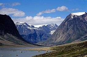 |
67°53′N 65°01′W / 67.883°N 65.017°W |
2001 | 19,089 km2 (7,370 sq mi) | Northern Davis region | One of Canada's largest parks and located almost entirely within the Arctic Circle, Auyuittuq on Baffin Island preserves a rugged arctic wilderness featuring some of the highest peaks of the Canadian Shield.[15] |
| Banff‡ | 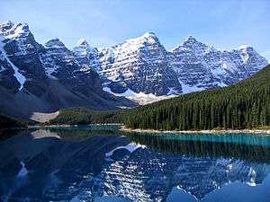 |
51°30′N 116°0′W / 51.500°N 116.000°W |
1885 | 6,641 km2 (2,564 sq mi) | Rocky Mountains | The first park established by the federal government of Canada, Banff includes the Valley of the Ten Peaks, the Wapta and Waputik Icefields, several ski resorts, and the communities of Lake Louise and Banff. It is part of the Canadian Rocky Mountain Parks World Heritage Site and adjacent to the Kootenay and Yoho National Parks, and its boundary with the Jasper National Park at Snow Dome is a hydrological apex of North America. |
| Bruce Peninsula | 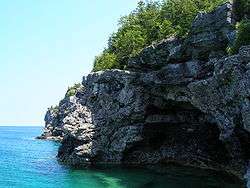 |
45°14′N 81°37′W / 45.233°N 81.617°W |
1987 | 125 km2 (48 sq mi) | St. Lawrence lowlands | Formed from lands previously designated Ontario's Cyprus Lake Provincial Park, Bruce preserves a unique shoreline formation of the Niagara Escarpment and forms part of the larger UNESCO Niagara Escarpment Biosphere Reserve. The Bruce Trail, one of Canada's longest hiking trails, passes through the park. The locally threatened massasauga rattlesnake is found within the park, as well as Canada's southernmost population of black bears.[12]:142–143 |
| Cape Breton Highlands | 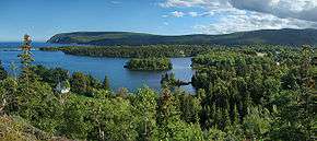 |
46°43′N 60°40′W / 46.717°N 60.667°W |
1936 | 948 km2 (366 sq mi) | Maritime Acadian highlands | Atlantic Canada's oldest national park features Acadian and boreal forest environments in the Cape Breton Highlands. One-third of the Cabot Trail passes through the central portion of the park. Most of Nova Scotia's population of Canada lynx are found in this park, and the endangered North Atlantic right whale is found in waters off the park's coast.[12]:42–43[16] Western moose were introduced to this park from Alberta's Elk Island National Park between 1947 and 1948, the native eastern moose having been hunted to near-extinction.[17][18] |
| Elk Island | 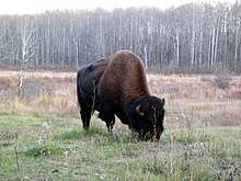 |
53°37′N 112°52′W / 53.617°N 112.867°W |
1913 | 194 km2 (75 sq mi) | Southern boreal plains & plateaux | Created as a wildlife sanctuary for elk, the park has become a part of bison conservation, the Beaver Hills Dark Sky Preserve, and the Beaver Hills Biosphere Reserve.[19] Eighteen moose (nine males and nine females) from Elk Island were introduced to Nova Scotia's Cape Breton Highlands National Park between 1947 and 1948.[18] |
| Forillon | 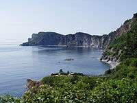 |
48°54′N 64°21′W / 48.900°N 64.350°W |
1970 | 240 km2 (93 sq mi) | Notre Dame & Megantic Mountains | The lands of the first park in Quebec were traditional hunting and fishing grounds for the Mi'kmaq and Iroquois, and were exploited for their rich supplies of lumber.[12]:98–99 Two hundred twenty-five families were controversially expropriated from the park lands prior to creation of the park in 1970. In 2011, the Government of Canada issued a formal apology to these families for their mistreatment.[20] |
| Fundy | 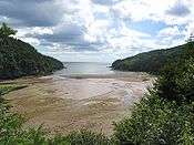 |
45°36′N 64°57′W / 45.600°N 64.950°W |
1948 | 206 km2 (80 sq mi) | Maritime Acadian highlands | Featuring the highest tides in the world, the Bay of Fundy exposes ocean floor at low tide which is covered by up to 16 metres (52 ft) of salt water at high tide.[21] The park forms the core portion of the UNESCO Fundy Biosphere Reserve. |
| Georgian Bay Islands | 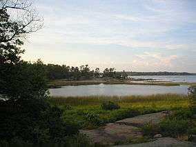 |
44°53′N 79°52′W / 44.883°N 79.867°W |
1930 | 14 km2 (5 sq mi) | Great Lakes—St. Lawrence precambrian region | Beausoleil Island is the largest of the small islands which make up the park, which originally included Flowerpot Island. The islands form part of the UNESCO Georgian Bay Littoral Biosphere Reserve. |
| Glacier | 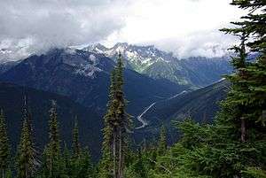 |
51°18′N 117°31′W / 51.300°N 117.517°W |
1886 | 1,349 km2 (521 sq mi) | Columbia Mountains | Representative of the Columbia Mountains natural region, this park includes Illecillewaet Glacier, Rogers Pass, Nakimu Caves, Mount Sir Donald, and Mount Dawson.[22] |
| Grasslands | 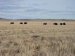 |
49°12′N 107°43′W / 49.200°N 107.717°W |
1981 | 730 km2 (282 sq mi) (905 km2 (349 sq mi) proposed) |
Prairie grasslands | Located along the borders with the American state of Montana, the park features an undisturbed mixed-grass prairie ecosystem and badlands where fossils from both the Frenchman and Bearpaw Formations were discovered including those of a Triceratops and a Tyrannosaurus.[23] |
| Gros Morne‡ | 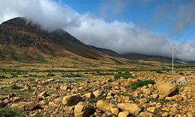 |
49°41′N 57°44′W / 49.683°N 57.733°W |
1973 | 1,805 km2 (697 sq mi) | Western Newfoundland highlands | A World Heritage Site due to its exposed mantle and crust as an example of plate tectonics, the park also includes Western Brook Pond, Lobster Cove, and Gros Morne mountain in the Long Range Mountains chain.[24] |
| Gulf Islands (Reserve) |
 |
48°51′N 123°27′W / 48.850°N 123.450°W |
2003 | 37 km2 (14 sq mi) | Strait of Georgia lowlands | Representative of the Strait of Georgia Lowlands, the park includes 6 km2 of marine environment and land on 15 islands.[25] |
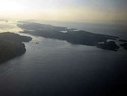
| Gwaii Haanas‡[lower-alpha 1] (Reserve) |
 |
52°23′N 131°28′W / 52.383°N 131.467°W |
1988 | 1,474 km2 (569 sq mi) | Pacific coast mountains | Forming the southern end of the Haida Gwaii archipelago, the park is on the far western end of Canada and includes 138 islands, inclusive of Ninstints World Heritage Site, Hotspring Island, and the southern tip of Moresby Island. |
| Ivvavik[lower-alpha 2] | 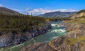 |
69°31′N 139°31′W / 69.517°N 139.517°W |
1984 | 9,750 km2 (3,764 sq mi) | Northern Yukon | Adjacent to Vuntut National Park and the American Arctic National Wildlife Refuge, the park has arctic tundra that was not glaciated during the last ice age and consequently contains the oldest river in Canada, the Firth River. Ivvavik is the first national park created as a result of an aboriginal land claim agreement, the Inuvialuit Final Agreement.[28] |
| Jasper‡ | 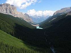 |
52°48′N 117°54′W / 52.800°N 117.900°W |
1907 | 11,228 km2 (4,335 sq mi) | Rocky Mountains | Part of the Canadian Rocky Mountain Parks World Heritage Site and adjacent to the Banff National Parks, as well as Mount Robson and Hamber Provincial Parks in British Columbia, this park includes the community of Jasper, Columbia Icefield, Athabasca Falls, Sunwapta Falls, Maligne Lake, and canyon, and the Snow Dome, a hydrological apex of North America, at its boundary with the Banff National Park. |
| Kejimkujik | 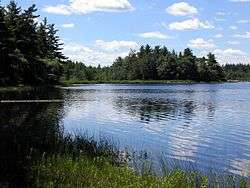 |
44°24′N 65°13′W / 44.400°N 65.217°W |
1967 | 404 km2 (156 sq mi) | Atlantic coast plain | The area around Kejimikujik Lake was acquired by the federal government for park purposes in 1967 and added a 22 km2 seaside component in 1985. The inland portion was designated a National Historic Site in 1995 recognizing its Mi'kmaw cultural landscape and is adjacent to the Tobeatic Wilderness Area. The park is part of the Southwest Nova Biosphere Reserve and a dark-sky preserve.[29] |
| Kluane‡[lower-alpha 3] (two units: a Park and a Reserve) |
 |
60°37′N 138°20′W / 60.617°N 138.333°W |
1972 (Reserve) 29 May 1993 (Park) |
21,980 km2 (8,487 sq mi) | Northern coast mountains | Part of a World Heritage Site and adjacent to the American Wrangell–St. Elias National Park and British Columbian Tatshenshini-Alsek Provincial Park, Kluane features the highest mountain peaks in Canada, including Mount Logan, and the largest non-polar ice field in the world.[30] |
| Kootenay‡ | 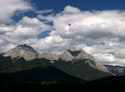 |
50°53′N 116°03′W / 50.883°N 116.050°W |
1920 | 1,406 km2 (543 sq mi) | Rocky Mountains | Part of the Canadian Rocky Mountain Parks World Heritage Site and adjacent to the Banff and Yoho National Parks, as well as the Mount Assiniboine Provincial Park, the park is representative of the Rocky Mountains natural region and includes the Radium Hot Springs pools, an outcrop of the Burgess Shale fossil deposit, Numa Falls, and Floe Lake. |
| Kouchibouguac | 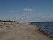 |
46°51′N 64°58′W / 46.850°N 64.967°W |
1969 | 239 km2 (92 sq mi) | Maritime plain | Located on the coast where the Kouchibouguac River enters the Northumberland Strait, across from the north end of Prince Edward Island, the park illustrates coastal dynamics, including tidal rivers, coastal dunes, salt marshes, bogs, and barrier islands.[31] |
| La Mauricie | 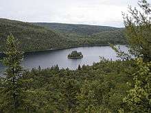 |
46°48′N 72°58′W / 46.800°N 72.967°W |
1970 | 536 km2 (207 sq mi) | Great Lakes—St. Lawrence precambrian region | Located north of Shawinigan, and between Saint-Maurice River, Matawin River, and Mastigouche Wildlife Reserve, the park features a canoe camping circuit and habitat for the wood turtle.[32] |
| Mingan Archipelago (Reserve) |
 |
50°13′N 63°10′W / 50.217°N 63.167°W |
1984 | 151 km2 (58 sq mi) | St. Lawrence lowlands | Located along the Gulf of St. Lawrence, the park consists of the Mingan Archipelago with its limestone outcrops and Atlantic puffin habitat. |
| Mount Revelstoke | 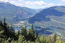 |
51°05′N 118°04′W / 51.083°N 118.067°W |
1914 | 262 km2 (101 sq mi) | Columbia Mountains | Accessible by a trail from the City of Revelstoke, the park is representative of the Columbia Mountains natural region.[22] |
| Nááts'ihch'oh (Reserve) |
 |
62°22′N 127°58′W / 62.367°N 127.967°W |
2014 | 4,850 km2 (1,873 sq mi) | Mackenzie Mountains | Adjacent to the Nahanni National Park, Nááts'įhch'oh extends the protected area into the Sahtu Settlement Area to include additional land with the South Nahanni River watershed to Mount Nááts’įhch’oh and the Moose Ponds.[33] |
| Nahanni‡ (Reserve) |
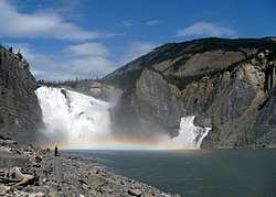 |
61°33′N 125°35′W / 61.550°N 125.583°W |
1972 | 30,000 km2 (11,583 sq mi)[lower-alpha 4] | Mackenzie Mountains | Containing the first natural World Heritage Site in Canada, the park includes the South Nahanni River, Virginia Falls, the Cirque of the Unclimbables, and a limestone cave system.[35] |
| Pacific Rim (Reserve) |
 |
48°38′N 124°46′W / 48.633°N 124.767°W |
1970 | 510 km2 (197 sq mi) | Pacific coast mountains | Representative of the coastal plain portion of the Pacific Coast Mountains natural region, the park is divided into three separated parts: Long Beach, the Broken Group islands, and the West Coast Trail.[36] |
| Point Pelee | 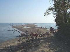 |
41°58′N 82°31′W / 41.967°N 82.517°W |
1918 | 15 km2 (6 sq mi) | St. Lawrence lowlands | The first national park established for conservation, Point Pelee is the southernmost point of the Canadian mainland, and also includes the southernmost point overall on Middle Island. The marshy wetland environment is a known stop for migratory birds and monarch butterflies,[37] and since 1987 is a Ramsar Convention Wetland of International Importance.[38] |
| Prince Albert | 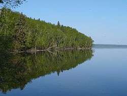 |
53°58′N 106°22′W / 53.967°N 106.367°W |
1927 | 3,875 km2 (1,496 sq mi) | Southern boreal plains & plateaux | Established with a recreation focus, the park includes a small community on the east end of Waskesiu Lake and features fescue grasslands with plains bison, boreal forest, and Ajawaan, Lavallee, and other lakes.[39] |
| Prince Edward Island | 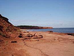 |
46°25′N 63°05′W / 46.417°N 63.083°W |
1937 | 27 km2 (10 sq mi) | Maritime plain | Sensitive sand beaches and dunes on the island's north shore provide nesting habitat for the endangered piping plover and are designated an Important Bird Area. An extension added in 1998 protects parabolic sand dunes and an area with archaeological evidence of Paleo-Indian occupation up to 10,000 years ago.[40] The park also encompasses Green Gables, the inspiration for the popular Anne of Green Gables novels.[12]:62–63 |
| Pukaskwa |  |
48°15′N 85°53′W / 48.250°N 85.883°W |
1971 | 1,878 km2 (725 sq mi) | Central boreal uplands | Located on the Voyageur Hiking Trail and the longest stretch of undeveloped shoreline in the Great Lakes,[41] Pukaskwa protects an area of boreal forest largely untouched by logging and mining industries, owing to the terrain's remarkable ruggedness.[12] A large cluster of the Pukaskwa Pits are located within the park. |
| Qausuittuq | 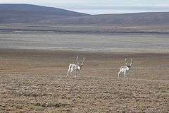 |
76°00′N 100°00′W / 76.000°N 100.000°W |
2015 | 11,008 km2 (4,250 sq mi) | Western high Arctic | Located on Bathurst Island, the park is adjacent to the Polar Bear Pass National Wildlife Area and protects Peary caribou and muskox habitat. |
| Quttinirpaaq[lower-alpha 5] | 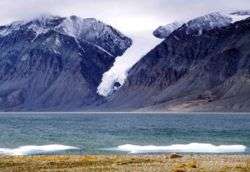 |
82°13′N 72°13′W / 82.217°N 72.217°W |
1988 | 37,775 km2 (14,585 sq mi) | Eastern high Arctic | Located on the polar desert of Ellesmere Island at the northern tip of Canada, the park includes Tanquary Fiord, Barbeau Peak, Lake Hazen, and Fort Conger. |
| Riding Mountain |  |
50°52′N 100°02′W / 50.867°N 100.033°W |
1929 | 2,968 km2 (1,146 sq mi) | Southern boreal plains & plateaux | Part of the Riding Mountain Biosphere Reserve,[43] the park features both boreal and aspen forests among the larger grassland prairie landscape, interspersed with pothole lakes and marshes. The park has an outdoor recreation focus and includes the community of Wasagaming, the East Gate National Historic Site, and formerly the Whitewater prisoners-of-war camp.[44] |
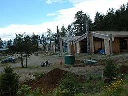
| Rouge | 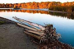 |
43°56′N 79°14′W / 43.933°N 79.233°W |
2015 | 79.1 km2 (31 sq mi) | St. Lawrence lowlands | Located in the Greater Toronto Area beginning at the mouth of the Rouge River and through the east end of Scarborough and Markham, the park includes riparian corridors and wetlands with habitat for the Blanding's turtle, as well as the site of the Bead Hill National Historic Site. |
| Sable Island (Reserve) |
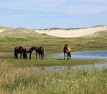 |
43°57′N 59°55′W / 43.950°N 59.917°W |
2013 | 30 km2 (12 sq mi) | Atlantic coast plain | Consisting of Sable Island at the edge of the continental shelf off the coast of Nova Scotia, the island of sand is home to the Sable Island horse and provides habitat for grey seals and beach grass. |
| Sirmilik | 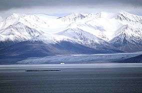 |
72°59′N 81°8′W / 72.983°N 81.133°W |
2001 | 22,200 km2 (8,571 sq mi) | Eastern Arctic lowlands[45] | Located on the eastern end of Nunavut, Sirmilik consists of the Byam Martin Mountains of Bylot Island and Baffin Island's Borden Peninsula and Oliver Sound. |
| Terra Nova | 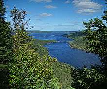 |
48°32′N 53°56′W / 48.533°N 53.933°W |
1957 | 399 km2 (154 sq mi) | Eastern Newfoundland Atlantic region | The eastern-most national park, Terra Nova is located on the east coast of Newfoundland along the Trans-Canada Highway. The park is characteristic of the Newfoundland landscape of low relief and rounded hills, and a rocky coastline of arms, sounds, coves, inlets, sea arches, and caves, as well as habitat for the Newfoundland pine marten.[46] |
| Thousand Islands | 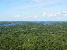 |
44°21′N 75°57′W / 44.350°N 75.950°W |
1904 | 24 km2 (9 sq mi) | St. Lawrence lowlands | The park is scattered over all or portions of 26 islands and 80 islets and shoals in the St. Lawrence River, as well as several mainland properties in Leeds and Grenville, east of Kingston, and within the Frontenac Arch Biosphere Reserve. |
| Torngat Mountains | 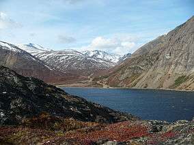 |
59°26′N 63°52′W / 59.433°N 63.867°W |
2005 | 9,700 km2 (3,745 sq mi) | Northern Labrador mountains | Located on the northernmost tip of Labrador, adjacent to Quebec's Kuururjuaq Park, and established as part of Inuit Land Claims Agreements, the park includes the Torngat Mountains, Labrador Sea coastline, and Pre-Dorset, Dorset, and Thule archaeological finds.[47] |
| Tuktut Nogait | 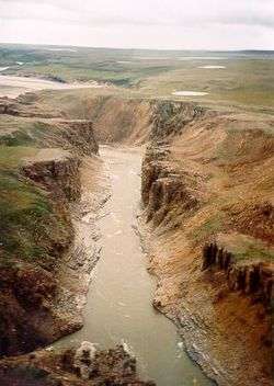 |
68°49′N 121°45′W / 68.817°N 121.750°W |
1998 | 18,181 km2 (7,020 sq mi) | Tundra hills | Within the Inuvialuit Settlement Region, the park was created to protect the Bluenose-West caribou herd and harvesting rights for the Inuvialuit people. It was expanded in 2005 to include a portion of the Sahtu Settlement Area.[48] |
| Ukkusiksalik |  |
65°21′N 87°18′W / 65.350°N 87.300°W |
2003 | 20,880 km2 (8,062 sq mi) | Central tundra[49] | Named after the Inuit word for soapstone, the park surrounds Wager Bay which is maternity denning areas for polar bears and includes cultural relics of the Dorset and Thule and Aivilingmiut people.[49] |
| Vuntut |  |
68°22′N 139°51′W / 68.367°N 139.850°W |
1993 | 4,345 km2 (1,678 sq mi) | Northern Yukon | Adjacent to the Ivvavik National Park and the American Arctic National Wildlife Refuge, the park area was not glaciated during the last ice age and now hosts Pleistocene fossil sites. Remote and inaccessible by road, the park was established, and is operated, in collaboration with the Vuntut Gwitchin First Nation as part of that nation's Final Agreement with Canada.[50] |
| Wapusk |  |
57°46′N 93°22′W / 57.767°N 93.367°W |
1996 | 11,475 km2 (4,431 sq mi) | Hudson—James lowlands | Created from a portion of the provincial Churchill Wildlife Management Area, Wapusk helps protect the land base that act as maternity denning areas for polar bears.[51] |
| Waterton Lakes‡[lower-alpha 6] |  |
49°03′N 113°55′W / 49.050°N 113.917°W |
1895 | 505 km2 (195 sq mi) | Rocky Mountains | Coupled with American neighbour Glacier National Park in Montana, the Waterton-Glacier International Peace Park is both a World Heritage Site and the oldest transboundary protected area in the world. Anchored by Waterton Lake, home of the historic Prince of Wales Hotel, the park is famous for hiking attractions such as the Crypt Lake Trail. |
| Wood Buffalo‡ | 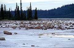 |
59°23′N 112°59′W / 59.383°N 112.983°W |
1922 | 44,972 km2 (17,364 sq mi) | Northern boreal plains | The largest park in Canada, the park protects the habitat of the wood bison and the breeding grounds of the whooping crane and much of the Peace–Athabasca Delta. It is also a World Heritage Site and the world's largest dark-sky preserve. |
| Yoho‡ |  |
51°24′N 116°29′W / 51.400°N 116.483°W |
1886 | 1,313 km2 (507 sq mi) | Rocky Mountains | Part of the Canadian Rocky Mountain Parks World Heritage Site and adjacent to the Banff and Kootenay National Parks, Yoho includes the community of Field, Burgess Shale fossil deposit, Emerald Lake, Takakkaw Falls, and Kicking Horse River. |
Proposed National Park Reserves
The following are areas which Parks Canada is in the process of evaluating as potential parks. While they may be reserved from alienation or have federal-provincial/territorial agreements, they have not been formally established through legislation as parks.
| Name | Location | Area | Natural region |
|---|---|---|---|
| Manitoba Lowlands[52] | 53°46′N 99°4′W / 53.767°N 99.067°W |
Approx. 5,000 km2 (1,931 sq mi)[53] | Manitoba lowlands |
| South Okanagan—Similkameen[54] | 49°4′N 119°41′W / 49.067°N 119.683°W |
Approx. 284 km2 (110 sq mi)[55] | Interior dry plains[55] |
| Thaidene Nene[56] | 62°30′N 111°00′W / 62.500°N 111.000°W |
Approx. 14,000 km2 (5,405 sq mi)[57] | Northwestern boreal uplands[58] |
Abolished National Parks
| Name | Location | Established | Abolished |
|---|---|---|---|
| Brereton Lake[59] | 1922 | 1930 | |
| Buffalo National Park[60] | 7 March 1908 | 17 July 1947 | |
| Menissawok National Park[61] | 31 May 1922 | 30 May 1930 | |
| Nemiskam National Park[60] | 1914 | 17 July 1947 | |
| Vidal Point Dominion Park[62] | 31 October 1921 | 30 May 1930 | |
| Wawaskesy National Park[63] | 31 May 1922 | 24 June 1938 |
National Marine Conservation Areas
National Marine Conservation Areas (NMCAs) are a relatively new invention in the park system. The goal of the NMCA system is to preserve areas representing Canada's 29 marine regions as identified by Parks Canada.[64] They are designed for sustainable use, although they usually also contain areas designed to protect ecological integrity.[65] Lake Superior National Marine Conservation Area, created in 2015, is the only unit that uses this designation in its name. Fathom Five National Marine Park was created in 1987, prior to the NMCA concept, and subsequently classified as an NMCA without changing its legal name. Saguenay–St. Lawrence Marine Park is jointly administered by Parks Canada and its Quebec counterpart, Sépaq. National Marine Conservation Area Reserves are protected areas proposed to be added to the NMCA system pending settlement of indigenous land and water rights. In the interim, they are administered under park rules.
As of 2018, established NMCAs and NMCA Reserves protect 14,846 km2 (5,732 sq mi) of waters, wetlands, and coastlines, representing five of the 29 identified marine regions with studies underway for protected areas in three additional regions.[64]
| Name | Photo | Location | Established[12] | Area (2017)[12] | Marine region[64] | Description |
|---|---|---|---|---|---|---|
| Fathom Five | 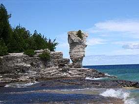 |
45°19′N 81°38′W / 45.317°N 81.633°W |
1987 | 114 km2 (44 sq mi) | Georgian Bay | The marine counterpart to Bruce National Park, Fathom Five is named for a line in Shakespeare's The Tempest. The first marine unit in the national parks system preserves a unique aquatic environment and several small islands including Flowerpot Island. The unusually clear waters and numerous shipwrecks on the shoals of Georgian Bay make the park a popular destination for scuba divers.[12]:189 |
| Gwaii Haanas (Reserve) |  |
52°0′N 131°12′W / 52.000°N 131.200°W |
2010 | 1,500 km2 (579 sq mi)[66] | Hecate Strait, Queen Charlotte Shelf | Along with the national park reserve of the same name, Gwaii Haanas protects an area extending from the ocean floor of the Hecate Strait and Queen Charlotte Basin to the mountains of the Haida Gwaii. The marine reserve preserves the Haida people's traditional use of the waters while protecting the area from oil exploration and commercial fishing.[12]:299 |
| Lake Superior | 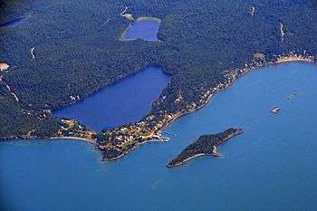 |
48°26′N 89°13′W / 48.433°N 89.217°W |
2007 | 10,880 km2 (4,201 sq mi) | Lake Superior | Adjacent to the United States' Isle Royale National Park and several Ontario provincial parks, Lake Superior NMCA forms part of the world's largest freshwater reserve.[67] |
| Saguenay–St. Lawrence | 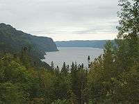 |
48°4′N 69°40′W / 48.067°N 69.667°W |
1998 | 1,245 km2 (481 sq mi)[68] | St. Lawrence Estuary | Located at the confluence of the Saguenay and St. Lawrence rivers and adjacent to Quebec's Saguenay Fjord National Park, Saguenay–St. Lawrence protects a portion of the St. Lawrence estuary, a common feeding ground for marine mammals such as the endangered St. Lawrence beluga whale. |
Proposed National Marine Conservation Areas
| Study area | Location | Area | Marine region[64] |
|---|---|---|---|
| Magdalen Islands[69][70] | 47°35′N 61°32′W / 47.583°N 61.533°W |
16,500 km2 (6,371 sq mi) | Magdalen shallows |
| Southern Strait of Georgia (Reserve)[71] | 49°18′N 123°48′W / 49.300°N 123.800°W |
1,400 km2 (541 sq mi) | Strait of Georgia |
| Tallurutiup Imanga[72] | 74°13′N 84°0′W / 74.217°N 84.000°W |
109,000 km2 (42,085 sq mi) | Lancaster Sound |
National Landmark
In addition to national parks, a National Landmarks program was established in 1978 but has not yet been expanded beyond a single property. Landmarks were intended to protect specific natural features considered "outstanding, exceptional, unique, or rare to this country. These natural features would typically be isolated entities and of scientific interest."[73]
| Name | Photo | Location | Established[12] | Area (2017)[12] | Description |
|---|---|---|---|---|---|
| Pingo | 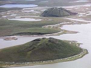 |
69°24′N 133°05′W / 69.400°N 133.083°W |
1984 | 16 km2 (6 sq mi) | Located on the shore of the Arctic Ocean, Canada's only National Landmark preserves eight ice-cored mounds known as pingos including Canada's largest, Ibyuk Pingo, along with other land and ice formations unique to the permafrost environment. |
See also
Provincial parks are administered and funded by the provincial governments, however some provincial parks are categorized as national parks (Category II) under the IUCN's Protected Area Management Categories.
Gatineau Park in Quebec is another park under the jurisdiction of the federal government. However, it is managed by the National Capital Commission, not Parks Canada, and is not considered part of the national parks system.
Notes
- ↑ South Moresby National Park Reserve was created 12 July 1988, with the signing of the South Moresby Agreement; renamed Gwaii Haanas National Park Reserve and Haida Heritage Site on 28 February 1996. Includes SGaang Gwaii (Anthony Island) World Heritage Site.[26]
- ↑ Established as Northern Yukon National Park in 1984, renamed Ivvavik National Park in 1992.[27]
- ↑ Kluane National Park Reserve was set aside in 1976, following the Kluane Game Reserve of the early 1940s. Subsequently, an eastern portion of the Reserve became Kluane National Park in 1993.
- ↑ In 2007, the government announced that 29,000 km2 (11,197 sq mi) of land would be added to Nahanni, making it 33,766 km2 (13,037 sq mi). However, these changes have not been fully implemented as of 2017.[34]
- ↑ Ellesmere Island National Park Reserve was established in 1988, renamed Quttinirpaaq in 1999, and became a national park in 2000.[42]
- ↑ Waterton Lakes National Park is part of Waterton-Glacier International Peace Park, a World Heritage Site which includes the adjoining Glacier National Park in Montana, United States.
References
- 1 2 "Canada National Parks Act S.C. 2000, c. 32". Government of Canada. October 12, 2000. Retrieved January 25, 2018.
- ↑ "National Parks of Canada – Introduction". Parks Canada. Retrieved 13 December 2017.
- ↑ "Order-in-Council #2197-1885". Library and Archives Canada. November 25, 1885. Retrieved January 24, 2018.
- ↑ Lothian, W.F. (1981). A Brief History of Canada's National Parks (PDF). Environment Canada. ISBN 0-662-15217-4. Retrieved January 24, 2018.
- ↑ Irish, Paul (13 May 2011). "Parks Canada celebrates a century of discovery". Toronto Star. Retrieved 24 January 2018.
- ↑ Binnema, Theodore; Niemi, Melanie (2006). "'Let the line be drawn now': Wilderness, Conservation, and the Exclusion of Aboriginal People from Banff National Park in Canada". Environmental History. 11 (4): 724–50. doi:10.1093/envhis/11.4.724.
- ↑ Joseph, Bob (13 March 2015). "Can First Nations hunt in national parks?". Indigenous Corporate Training, Inc. Retrieved 24 January 2018.
- ↑ "Indigenous fact sheet". Parks Canada. 23 June 2017. Archived from the original on 11 December 2017. Retrieved 13 December 2017.
- ↑ "The system of national parks of Canada". Parks Canada. 10 January 2018. Retrieved 24 January 2018.
- ↑ "Parks Canada Attendance 2016–17". Parks Canada. 11 September 2017. Retrieved 25 January 2018.
- ↑ "Creating new national parks". Parks Canada. Retrieved 13 December 2017.
- 1 2 3 4 5 6 7 8 9 10 11 12 13 Guide to the National Parks of Canada. Washington, D.C.: National Geographic. 2017. ISBN 978-1-4262-1756-2.
- ↑ Parks Canada (1997). National Parks System Plan (PDF). ISBN 0-662-25334-5.
- ↑ "Aulavik National Park – Natural Environment". Parks Canada. 8 June 2017. Retrieved 13 December 2017.
- ↑ "Auyuittuq National Park – About". Parks Canada. 1 December 2017. Retrieved 14 December 2017.
- ↑ Ayers, Tom (September 22, 2015). "Right whales off Cape Breton going the wrong way for shipping, fishing". The Chronicle Herald. Retrieved January 10, 2018.
- ↑ "Moose Management". Nova Scotia Office of Aboriginal Affairs. February 2007. Retrieved 18 March 2018.
- 1 2 "Cape Breton Highlands National Park - Moose". Parks Canada. 3 January 2018. Retrieved 18 March 2018.
- ↑ Elk Island National Park of Canada Management Plan. Parks Canada. 2011. ISBN 978-1-100-18107-3.
- ↑ Rudin, Ronald (2011). "The First French-Canadian National Parks: Kouchibouguac and Forillon in History and Memory". Journal of the Canadian Historical Association. 22 (1): 161–200.
- ↑ "Where is the highest tide?". National Ocean Service. October 10, 2017. Retrieved January 10, 2018.
- 1 2 State of the Parks Report – Mount Revelstoke and Glacier National Parks. Parks Canada. 2008.
- ↑ Grasslands National Park Reserve of Canada Management Plan. Parks Canada. 2010. ISBN 978-1-100-15723-8.
- ↑ Gros Morne National Park of Canada Management Plan. Parks Canada. 2009. ISBN 0-662-44613-5.
- ↑ "Gulf Islands National Park Reserve". National Geographic. Retrieved January 5, 2018.
- ↑ "Gwaii Haanas National Park Reserve and Haida Heritage Site". The Canadian Encyclopedia. Retrieved 7 April 2008.
- ↑ "Ivvavik National Park". The Canadian Encyclopedia. Retrieved 7 April 2008.
- ↑ Ivvavik National Park Management Plan. Parks Canada. 2017.
- ↑ Kejimkujik National Park and National Historic Site of Canada Management Plan. Parks Canada. 2010. ISBN 978-1-100-13549-6.
- ↑ "Largest non-polar ice field". Guinness World Records. 2011. Retrieved January 6, 2018.
- ↑ Kouchibouguac National Park of Canada Management Plan. Parks Canada. 2010. ISBN 978-1-100-13556-4.
- ↑ La Mauricie National Park of Canada Management Plan. Parks Canada. 2010. ISBN 978-1-100-14153-4.
- ↑ Nááts’įhch’oh National Park Reserve of Canada Management Plan. Parks Canada. 2017. ISBN 978-0-660-09423-6.
- ↑ "Tories' expansion of Nahanni park praised". CTV Television Network. 8 August 2007. Retrieved 7 April 2008.
- ↑ Nahanni National Park Reserve of Canada Nahʔą Dehé Management Plan. Parks Canada. 2010. ISBN 978-1-100-15495-4.
- ↑ State of the Parks Report – Pacific Rim National Park Reserve. Parks Canada. 2008. ISBN 978-0-662-48932-0.
- ↑ "Monarch butterflies by the thousands at Point Pelee". CBC News. September 17, 2014. Retrieved January 10, 2018.
- ↑ "Point Pelee". Ramsar Sites Information Service. Retrieved January 10, 2018.
- ↑ Prince Albert National Park Reserve Management Plan. Parks Canada. 2017.
- ↑ Scheller, William G. (December 1999). "A Story Written in Sand". Islands Magazine. 19 (6): 23–24. Retrieved January 10, 2018.
- ↑ Otis, Daniel (January 8, 2018). "Trekking the wild shores of Lake Superior in Pukaskwa National Park". Toronto Star. Retrieved January 18, 2018.
- ↑ "Quttinirpaaq National Park". The Canadian Encyclopedia. Retrieved 7 April 2008.
- ↑ "Biosphere Reserve Information – Canada – Riding Mountain". UNESCO. Retrieved 7 April 2008.
- ↑ Riding Mountain National Park of Canada and Riding Mountain Park East Gate Registration Complex National Historic Site of Canada Management Plan. Parks Canada. 2007. ISBN 0-662-43469-2.
- ↑ Sirmilik National Park Management Plan. Parks Canada. 2016. Retrieved 25 January 2018.
- ↑ Terra Nova National Park of Canada Management Plan. Parks Canada. 2009. ISBN 978-1-100-10393-8.
- ↑ Torngat Mountains National Park Canada: management plan. Parks Canada. 2010. ISBN 978-1-100-13554-0.
- ↑ Tuktut Nogait National Park of Canada: management plan. Parks Canada. 2007. ISBN 978-0-662-42988-3.
- 1 2 Ukkusiksalik National Park of Canada: Management Plan (PDF). Parks Canada. 2017. Retrieved 25 January 2018.
- ↑ Vuntut National Park of Canada Management Plan. Parks Canada. 2010.
- ↑ Wapusk National Park of Canada Management Plan. Parks Canada. 2007. ISBN 978-0-662-47407-4.
- ↑ Glowacki, Laura (22 March 2017). "New Manitoba national park announced in 2017 budget home to white cliffs, turquoise lake". CBC News. Retrieved 25 January 2018.
- ↑ "Manitoba National Parks". Manitoba Wildlands. 30 May 2014. Retrieved 25 January 2018.
- ↑ Gaffney, Blaine (27 October 2017). "Efforts heat up to create a national park reserve in the south Okanagan". Global News. Retrieved 18 January 2018.
- 1 2 "Proposed National Park Reserve in the South Okanagan-Similkameen". Parks Canada. 18 January 2018. Retrieved 18 January 2018.
- ↑ "Ottawa, Dene agree to create vast national park". CBC News. 14 October 2006. Retrieved 7 April 2008.
- ↑ "Nature Canada Applauds Federal Government's Renewed Commitment to National Park System". Nature Canada. 16 October 2006. Retrieved 7 April 2008.
- ↑ "Thaidene Nëné Proposed National Park Reserve Ecological Values Summary". Parks Canada. Retrieved 18 January 2018.
- ↑ Hart, E. J. (2010). J. B. Harkin: Father of Canada's National Parks. Edmonton, AB: University of Alberta Press. p. 340.
- 1 2 Federation of Alberta Naturalists, Fish and Wildlife Historical Society (2005). Fish, Fur & Feathers: Fish and Wildlife Conservation in Alberta 1905–2005. Nature books of Alberta. p. 100. ISBN 0-9696134-7-4.
- ↑ "National Parks Act". Act of 30 May 1930. Retrieved 15 December 2017.
- ↑ Lothian, W. F. (1977). "Chapter 4: National Parks Administration (1885 to 1973)". A History of Canada's National Parks. II. Parks Canada. pp. 15–17.
- ↑ "Project Update: Arthropods of Canadian Grasslands". University of Alberta. Retrieved 7 April 2008.
- 1 2 3 4 "Completing the National Marine Conservation Areas System". Parks Canada. 30 March 2017. Retrieved 25 January 2017.
- ↑ "National Marine Conservation Area System". Parks Canada. 20 July 2017. Retrieved 15 December 2017.
- ↑ "Minister visits, celebrates marine park's creation". Haida Gwaii Observer. 14 June 2010. Retrieved 15 December 2017.
- ↑ "Canada creates world's biggest water reserve". Agence France-Presse. 25 October 2007. Archived from the original on 5 January 2008. Retrieved 23 January 2018.
- ↑ "Map of Saguenay-St. Lawrence Marine Park" (PDF). Ministère du Développement durable, de l'Environnement et des Parcs du Québec. Retrieved 17 February 2018.
- ↑ "Study on the Creation of a Marine Protected Area in Îles-de-la-Madeleine". Government of Quebec. 9 May 2012. Retrieved 15 December 2017.
- ↑ Parks Canada (2014). "Departmental Performance Report". Retrieved 18 January 2018.
- ↑ "Feasibility Study for the Proposed Southern Strait of Georgia National Marine Conservation Area Reserve". Parks Canada. 30 March 2017. Retrieved 15 December 2017.
- ↑ Lancaster Sound National Marine Conservation Area Feasibility Assessment Steering Committee (25 August 2017). "A National Marine Conservation Area Proposal for Lancaster Sound: Feasibility Assessment Report". Parks Canada. Archived from the original on 26 January 2018. Retrieved 25 January 2018.
- ↑ "Pingo Canadian Landmark – Park Management". Parks Canada. 15 June 2017. Retrieved 15 December 2017.
External links
| Wikimedia Commons has media related to National Parks of Canada. |
- National Parks of Canada
- National Marine Conservation Areas of Canada
- World Heritage Sites in Canada
- Park Search Canadian Parks Locator
| History |
| ||||
|---|---|---|---|---|---|
| Provinces and territories |
| ||||
| Government | |||||
| Politics | |||||
| Geography |
| ||||
| Economy | |||||
| Society | |||||
| Demographics |
| ||||
| Culture | |||||
| Symbols | |||||
| Article overviews | |||||
| Research | |||||
| |||||
| Authority control |
|---|