Mount Sir Donald
| Mount Sir Donald | |
|---|---|
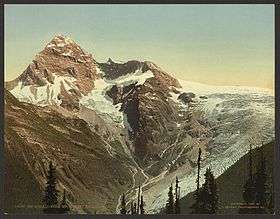 Mount Sir Donald from Mt. Abbott, c.1902 | |
| Highest point | |
| Elevation | 3,284 m (10,774 ft) [1] |
| Prominence | 874 m (2,867 ft) [1] |
| Parent peak | Mount Dawson |
| Coordinates | 51°15′47.2″N 117°25′53.0″W / 51.263111°N 117.431389°WCoordinates: 51°15′47.2″N 117°25′53.0″W / 51.263111°N 117.431389°W |
| Geography | |
 Mount Sir Donald | |
| Parent range | Selkirk Mountains |
| Topo map | NTS 82N6 |
| Climbing | |
| First ascent | Emil Huber, Carl Sulzer, Harry Cooper, 1890 |
Mount Sir Donald is a peak in the Rogers Pass area of British Columbia, Canada. Its good rock quality and classic Matterhorn shape make it popular for alpine rock climbers, and the Northwest Arete route is included in the popular book Fifty Classic Climbs of North America.
It was originally named Syndicate Peak in honor of the group who arranged the finances for the completion of the Canadian Pacific Railway, but was later renamed after Donald Smith, 1st Baron Strathcona and Mount Royal, head of the syndicate.[1]
The first ascent was made in 1890 by Emil Huber and Carl Sulzer of Switzerland and porter Harry Cooper.[1][2] As of the 1910s, an average of three or four ascents per year were being made.[3]
References
- 1 2 3 4 "Mount Sir Donald". Bivouac.com. Retrieved 2008-12-27.
- ↑ "On The Top Of Mount Sir Donald". The New York Times. 1890-08-08. Retrieved 2008-12-27.
- ↑ Howard Palmer (1914). Mountaineering and Exploration in the Selkirks. G. P. Putnam's sons. p. 46.
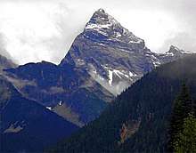
Mount Sir Donald seen from Highway 1
This article is issued from
Wikipedia.
The text is licensed under Creative Commons - Attribution - Sharealike.
Additional terms may apply for the media files.