Territorial evolution of Canada
The Dominion of Canada was formed on July 1, 1867, when the British colonies of Canada, New Brunswick, and Nova Scotia were merged to form a single Dominion within the British Empire. Canada continued to expand across North America as other British colonies and territories joined with or were ceded to Canada, eventually growing from four provinces to ten provinces and three territories. Politically, Canada gained increasing independence in the 20th century, eventually becoming a fully sovereign state in 1982.
Timeline
| Date | Event | Change |
|---|---|---|
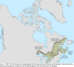
| July 1, 1867 | The Dominion of Canada was formed by the United Kingdom from three provinces of British North America:[1]
The capital was established at Ottawa. Canada inherited territorial disputes with the United States over Machias Seal Island and North Rock. |
 Disputes: 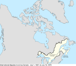 |
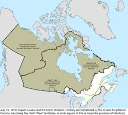
| July 15, 1870 | The United Kingdom transferred most of its remaining land in North America to Canada, with Rupert's Land and the North-Western Territory becoming the North-West Territories. Rupert's Land was transferred to Canada in 1869,[2] but the transfer was only consummated in 1870 when £300,000 was paid to the Hudson's Bay Company.[3] Due to a lack of quality surveying, a boundary dispute with the United States existed in the far southwestern corner of the transferred region.[4] Canada disagreed with the United Kingdom over the extent of Labrador that remained with Newfoundland Colony, citing the historical use of the term "Coasts of Labrador."
An area of the newly acquired region near the city of Winnipeg, bounded by the 96th and 99th meridians west, 50°30′ north, and the United States, was made the province of Manitoba.[5] |
 Disputes: 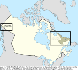 |
| July 20, 1871 | The British colony of British Columbia joined Canada as the sixth province.[6] The province brought along its dispute with the United States over the San Juan Islands,[7] as well as its portion of the Alaska boundary dispute.[4] | 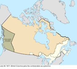 Disputes: 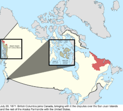 |
| October 21, 1872 | The dispute with the United States over the San Juan Islands was resolved in favour of the United States claim.[7] | 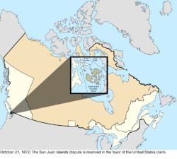 Disputes: 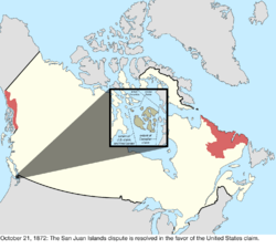 |
| July 1, 1873 | The British colony of Prince Edward Island joined Canada as the seventh province, Prince Edward Island.[8] | 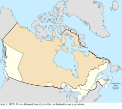 |
| June 26, 1874 | The borders of Ontario were provisionally expanded north and west. When the Province of Canada was formed, its borders were not entirely clear, and Ontario claimed to eventually reach all the way to the Rocky Mountains and Arctic Ocean. With Canada's acquisition of Rupert's Land, Ontario was interested in clearly defining its borders, especially since some of the new areas it was interested in were rapidly growing. After the federal government asked Ontario to pay for construction in the new disputed area, the province asked for an elaboration on its limits, and its boundary was moved north to the 51st parallel north, and west to a line running north from Hunter's Island.[9] | 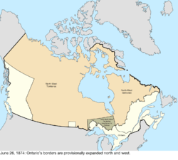 |
| October 7, 1876 | The District of Keewatin was created from a central strip of the North-West Territories to provide government for the growing area north of Manitoba and west of Ontario; while the North-West Territories consisted of several districts, Keewatin had an elevated status and many sources note it distinct from the rest of the North-West Territories. It was defined as the mainland area west of Ontario and Hudson Bay; east of Lake Manitoba, Lake Winnipegosis, and Cedar Lake, and a line north from Cedar Lake; and north of the United States.[10][11] | 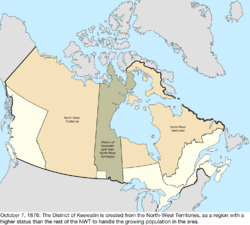 |
| September 1, 1880 | The United Kingdom transferred its Arctic Islands to Canada, where they were made part of the North-West Territories.[12] The archipelago was still being explored and new islands discovered, but the United Kingdom and Canada had claimed the whole archipelago, so new discoveries are not noted unless disputed. | 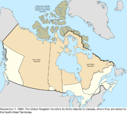 |
| December 23, 1881 | Manitoba was expanded, gaining land from the District of Keewatin and North-West Territories to the west, north, and east. Since the province's new eastern border was defined as the "western boundary of Ontario", the exact definition of which was still unclear, Ontario disputed a portion of the new region.[13][14][15] | 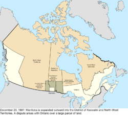 |
| May 7, 1886 | The southwestern border of the District of Keewatin was adjusted to conform to the boundaries of the provisional districts of the North-West Territories, returning land west of the Nelson River and Lake Winnipeg, and south of a line extending east from the northern border of the District of Saskatchewan, to the North-West Territories.[16] | 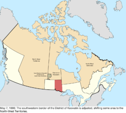 |
| August 12, 1889 | The dispute between Manitoba and Ontario ended as Ontario's borders were finalized, extending the province west to the Lake of the Woods and north to the Albany River.[17] | 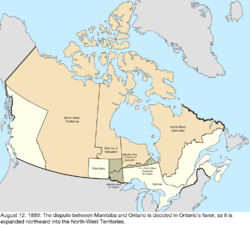 |
| October 2, 1895 | The District of Keewatin was expanded to the portion of the North-West Territories north of Ontario.[18][19] | 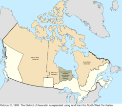 |
| December 18, 1897 | Southampton Island, Coats Island, Akimiski Island, and other islands were transferred from the North-West Territories to the District of Keewatin, and some mainland peninsulas were transferred from the District of Keewatin to the North-West Territories.[20][21] | 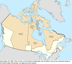 |
| June 13, 1898 | Yukon Territory was created from the District of Yukon in the northwestern part of the North-West Territories to supply a more local government to the explosive growth in population due to the Klondike Gold Rush. Quebec was enlarged north to the Eastmain River.[22] | 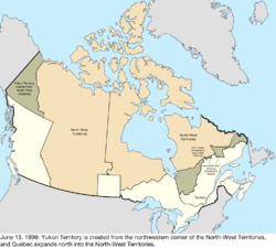 |
| May 23, 1901 | The eastern border of Yukon Territory was adjusted to the Peel River, so that the borders would not cross a watershed, and also to include some more islands, thus exchanging some area with the North-West Territories.[23] | 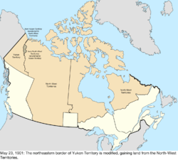 |
| October 20, 1903 | The Alaska boundary dispute was resolved, generally in favour of the United States claim.[4] | 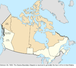 Disputes: 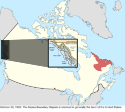 |
| September 1, 1905 | The provinces of Alberta (act) and Saskatchewan (act) were created from the North-West Territories. The provinces consisted of the area between British Columbia, Manitoba, the 60th parallel north, and the United States, with Alberta west of the 4th meridian of the Dominion Land Survey and Saskatchewan east of it. The status of the District of Keewatin was lowered back to the other districts of the North-West Territories.[24][25][26][27][28][29] | 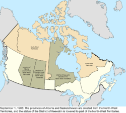 |
| 1906 | The North-West Territories were renamed the Northwest Territories.[30][31] | 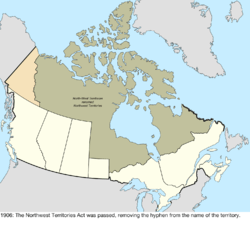 |
| September 26, 1907 | The Newfoundland Colony became a dominion of the United Kingdom, inheriting the Labrador boundary dispute. | Disputes: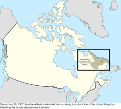 |
| April 11, 1908 | A boundary treaty redefined the maritime border with the United States.[32] Among other changes, this "de-enclaved" Horseshoe Reef in Lake Erie by making the water around it contiguous with the water on the American side of the border.[33][34] | no change to map |
| August 20, 1910 | A boundary treaty with the United States addressed a slight uncertainty in the maritime border in Passamaquoddy Bay between New Brunswick and the United States.[35][36] The border was adjusted to run east of Pope's Folly Island, which previously lay on the border line, and had been the subject of some debate for many years.[37][38] | 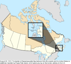 |
| May 15, 1912 | Manitoba, Ontario, and Quebec (act) were all expanded northward into land from the Northwest Territories.[30] Quebec was expanded north to fill the mainland, Manitoba extended north to the 60th parallel north, and the new border between Manitoba and Ontario ran northeast from the previous northeastern corner of Manitoba.[39] | 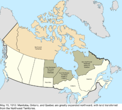 |
| June 1, 1925 | The maritime boundaries of the Northwest Territories were extended to the North Pole.[30] | no change to map |
| July 17, 1925 | The border with the United States was adjusted in several places.[40][41] The only change to a land border redefined how the border between the Lake of the Woods and the Rocky Mountains should be considered; previously, the border followed the curve of the parallel between each border monument, while the treaty changed this to straight lines between each monument. Through this, the United States netted a gain of between 30 and 35 acres of land. Due to the extremely small shift, the lack of specific documentation of where the changes occurred, and the lack of any human impact, this change is not mapped. There was also a change to the border in the Lake of the Woods; due to inaccurate surveying, the previous border intersected itself several times in the lake, creating enclaves of United States water surrounded by Canadian water. The treaty changed the border to use the southernmost intersection as the northwestern point of the Lake of the Woods. Finally, the maritime border in the Bay of Fundy was adjusted, netting Canada roughly 9 acres of water. | too small to map |
| March 11, 1927 | The Judicial Committee of the British Privy Council decided the Labrador boundary dispute with the Dominion of Newfoundland in favour of Newfoundland.[42] Quebec has occasionally indicated it does not recognize this border, but has not actively disputed the matter.[43] | 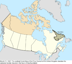 Disputes: 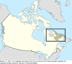 |
| November 11, 1930 | Norway ceded its long-dormant claim to the Sverdrup Islands to Canada, in exchange for British recognition of Norway's sovereignty over Jan Mayen. | Disputes: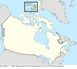 |
| December 11, 1931 | The Statute of Westminster 1931 largely grants Canada independence from the United Kingdom. | no change to map |
| March 31, 1949 | The Dominion of Newfoundland joined as the tenth province, Newfoundland.[44][45][46] | 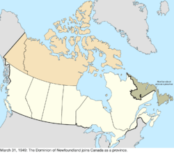 |
| March 13, 1974 | The maritime border with Denmark was defined, notably "skipping" Hans Island which lies directly between Ellesmere Island and Greenland, and which is technically on neither side of the border.[47] | no change to map |
| March 1, 1977 | The United States claimed maritime borders west of the Strait of Juan de Fuca, within the Dixon Entrance, and in the Beaufort Sea that conflicted with claims of Canada.[48] | no change to map |
| April 17, 1982 | The Constitution Act, 1982, via the Canada Act 1982, makes Canada completely independent of the United Kingdom, removing the requirement to involve the British parliament in amending the Canadian constitution. | no change to map |
| October 12, 1984 | The International Court of Justice decided the maritime border with the United States in the Gulf of Maine.[49] No land changed hands, and the scope of the case did not include the sovereignty of Machias Seal Island.[48] | no change to map |
| April 1, 1999 | The territory of Nunavut was created from roughly the eastern half of the Northwest Territories.[50][51] | 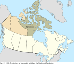 |
| December 6, 2001 | The province of Newfoundland was renamed Newfoundland and Labrador.[52] | 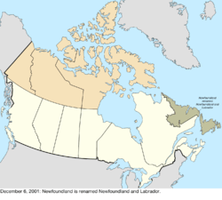 |
| April 1, 2003 | Yukon Territory was renamed Yukon.[53] | 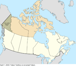 |
See also
- Former colonies and territories in Canada
- List of areas disputed by Canada and the United States
- List of Hudson's Bay Company trading posts
- List of French forts in North America
- Proposed provinces and territories of Canada
- Territorial claims in the Arctic
- Territorial evolution of North America since 1763
References
- ↑

- ↑
- ↑
- 1 2 3 Van Zandt, Franklin K. (1976). Boundaries of the United States and the Several States: With Miscellaneous Geographic Information Concerning Areas, Altitudes, and Geographic Centers. Washington, D.C.: U.S. Government Printing Office. p. 32. OCLC 69426475.
- ↑
- ↑
- 1 2 Van Zandt, Franklin K. (1976). Boundaries of the United States and the Several States: With Miscellaneous Geographic Information Concerning Areas, Altitudes, and Geographic Centers. Washington, D.C.: U.S. Government Printing Office. p. 18. OCLC 69426475.
- ↑
- ↑ Mills, David (1877). Report on the Boundaries of the Province of Ontario. Toronto: Hunter, Rose & Co. p. 347.
- ↑ Nicholson, Normal L. (1979). The Boundaries of the Canadian Confederation. Toronto: Macmillan Company of Canada Ltd. p. 113.
- ↑ "Territorial Evolution, 1876". GeoGratis. Natural Resources Canada. January 8, 2015. Retrieved October 17, 2015.
- ↑
- ↑ "Manitoba's Boundaries". Association of Manitoba Land Surveyors. Archived from the original on July 22, 2007. Retrieved August 18, 2009.
- ↑ "Territorial Evolution, 1881". GeoGratis. Natural Resources Canada. January 8, 2015. Retrieved October 17, 2015.
- ↑ Canada (3 August 1881). "Acts of the Parliament of the Dominion of Canada". Brown Chamberlin, Law Printer to the Queen's Most Excellent Majesty – via Google Books.
- ↑ Canada; Bligh, Harris Harding (3 August 1889). "The Consolidated Orders in Council of Canada: Under the Authority and Direction of His Excellency the Governor-general in Council". B. Chamberlain – via Google Books.
- ↑
- ↑ Keltie, J. Scott, ed. (1899). The Statesman's Year-Book. London: MacMillan & Co. p. 223.
- ↑ "Territorial Evolution, 1895". GeoGratis. Natural Resources Canada. January 8, 2015. Retrieved October 17, 2015.
- ↑ "Territorial Evolution, 1897". GeoGratis. Natural Resources Canada. January 8, 2015. Retrieved October 17, 2015.
- ↑ Extract from Order in Council (Dominion) of the 18th December, 1897, Establishing Provisional Districts in the Unorganized Portions of Canada (PDF). The Labrador Boundary Dispute Documents (Report). Volume VIII. pp. 4012–4013. Retrieved May 9, 2014.
- ↑
- ↑ Yukon Territory Act, S.C. 1901, c. 41, s. 14
- ↑
- ↑
- ↑ Thomson, Malcolm M.; Tanner, Richard W. (April 1977). "Canada's Prime Meridian". Journal of the Royal Astronomical Society of Canada. Toronto. 71: 204. Bibcode:1977JRASC..71..204T.
- ↑ Widdis, Randy (2006). "49th Parallel". The Encyclopedia of Saskatchewan. Canadian Plains Research Center, University of Regina. Retrieved January 6, 2009.
- ↑ Lewry, Marilyn (2006). "Boundary surveys". The Encyclopedia of Saskatchewan. Canadian Plains Research Center, University of Regina. Retrieved January 6, 2009.
- ↑ "Territorial Evolution, 1905". GeoGratis. Natural Resources Canada. January 8, 2015. Retrieved October 17, 2015.
- 1 2 3 "History of the Name of the Northwest Territories". Prince of Wales Northern Heritage Centre. Retrieved October 17, 2015.
- ↑ c.62, RSC 1906
- ↑ Van Zandt, Franklin K. (1976). Boundaries of the United States and the Several States: With Miscellaneous Geographic Information Concerning Areas, Altitudes, and Geographic Centers. Washington, D.C.: U.S. Government Printing Office. pp. 18–20. OCLC 69426475.
- ↑ Treaty between the United States of America and the United Kingdom Concerning the Boundary between the United States and the Dominion of Canada from the Atlantic Ocean to the Pacific Ocean, signed April 11, 1908; accessed June 30, 2015
- ↑ International Boundary between the United States and the Dominion of Canada through the St. Lawrence River and Great Lakes, Sheet No. 12 – Niagara River (Map). Buffalo, New York: International Waterways Commission. August 15, 1913. Retrieved 2016-08-08.
- ↑ 36 Stat. 2477
- ↑ Van Zandt, p. 20
- ↑ "Who Owns Pope's Folly Island?". The New York Times. June 20, 1893. Retrieved May 11, 2015.
- ↑ Link to a download for the United States Geological Survey map of the Eastport Quadrangle from 1907:
- ↑ "Ontario Boundaries Extension Act".
- ↑ "Treaty Between Canada and the United States of America to define more accurately and to complete the International Boundary between the two Countries" (PDF). February 24, 1925. Retrieved May 8, 2015.
- ↑ Van Zandt, pp. 21–22
- ↑ "Henri Dorion debunks the Ten Great Myths about the Labrador boundary". Quebec – National Assembly – First Session, 34th Legislature. October 17, 1991. Archived from the original on October 26, 2009. Retrieved October 17, 2015.
- ↑ "Henri Dorion debunks the Ten Great Myths about the Labrador boundary". Quebec National Assembly, First Session, 34th Legislature. October 17, 1991. Archived from the original on October 26, 2009. Retrieved May 18, 2011.
- ↑
- ↑ Webb, Jeff A. (March 2008). "The Commission of Government, 1934-1949". Heritage: Newfoundland & Labrador. Memorial University of Newfoundland and the C.R.B. Foundation. Retrieved October 17, 2015.
- ↑ "Territorial Evolution, 1949". GeoGratis. Natural Resources Canada. January 8, 2015. Retrieved October 17, 2015.
- ↑ "Agreement relating to the delimitation of the continental shelf between Greenland and Canada (with annexes); signed December 17, 1973; United Nations Treaty Series 13550" (PDF). Retrieved May 12, 2017.
- 1 2 Gray, David H. (Autumn 1997). "Canada's Unresolved Maritime Boundaries" (PDF). IBRU Boundary and Security Bulletin. pp. 61–67. Retrieved 2015-03-21.
- ↑ Case Concerning Delimitation of the Maritime Boundary in the Gulf of Maine Area (Canada v. United States) Archived 2016-08-17 at the Wayback Machine., accessed June 30, 2015
- ↑ "Nunavut Act". Government of Canada. Retrieved May 12, 2017.
- ↑ "Territorial Evolution, 1999". GeoGratis. Natural Resources Canada. January 8, 2015. Retrieved October 17, 2015.
- ↑ "Constitution Amendment, 2001 (Newfoundland and Labrador)". Government of Canada. December 6, 2001. Archived from the original on August 31, 2014. Retrieved October 17, 2015.
- ↑ "Yukon Territory name change to Yukon" (PDF). Library and Archives Canada. April 1, 2003. Retrieved July 14, 2009.
Further reading
- "Territorial Evolution". The Atlas of Canada. Natural Resources Canada. June 3, 2015.
- Hayes, Derek (2002). Historical Atlas of Canada. Douglas & McIntyre. ISBN 1-55054-918-9.
- Matthews, Geoffrey J (1987). Historical atlas of Canada, Volume 1. University of Toronto Press. ISBN 0-8020-2495-5.
External links
| Wikimedia Commons has media related to Territorial evolution of Canada. |
- Maps: 1667-1999 - Library and Archives Canada
- Territorial Evolution, 1670-2001 - Historical Atlas of Canada