Field, British Columbia


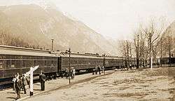
Field is an unincorporated community of approximately 169 people located in the Kicking Horse River valley of southeastern British Columbia, Canada, within the confines of Yoho National Park. At an elevation of 1,256 m (4,121 ft), it is 27 km (17 mi) west of Lake Louise along the Trans-Canada Highway which provides the only road access to the town.
Town Site Administration
Field’s land ownership was split between the Crown and the Canadian Pacific Railway (CPR), with the border between the two jurisdictions being Stephen Avenue. The railway was in charge of the water and electricity supply for the town until the 1950s, when the Canadian government took over. Today, the town site is managed by Parks Canada. Local residents lease their land from the park administration, with a term of 42 years.
The Burgess Shale
It was CPR train track workers in Field who discovered the fossils of the Burgess Shale locality. Commonly called by the workers ‘the stone bugs’, the very first fossils were discovered on Mt. Stephen.[1] In 1909, Charles D. Walcott discovered the Walcott Quarry on the slope of Mt. Field.
References
- ↑ Richard McConnell, of the Geological Survey of Canada, was mapping the geology around the railway line in September 1886, and was pointed to the Mount Stephen trilobite beds by a construction worker. Source : a b c Collins, D. (Aug 2009). "Misadventures in the Burgess Shale". Nature 460 (7258): 952. doi:10.1038/460952a. ISSN 0028-0836. PMID 19693066
External links
| Wikimedia Commons has media related to Field, British Columbia. |
- Field.ca - Information for people traveling to Field and Yoho National Park
- Fieldbc.ca - Community website and history of the town
- Friends of Yoho - The Friends of Yoho National Park Society promote appreciation, understanding and stewardship of the ecology and culture of Yoho National Park
- BC Archives Photo: Mount Stephen Hotel and CPR Station in Field, 1905
Coordinates: 51°23′48″N 116°29′9″W / 51.39667°N 116.48583°W