List of mountain ranges in Washington

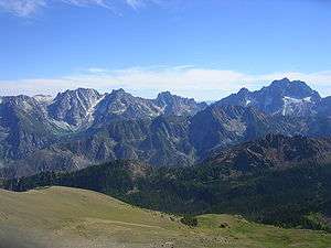
Stuart Range from Cashmere Peak

There are at least 63 named mountain ranges in the United States of America state of Washington. Names, elevations and coordinates from the U.S. Geological Survey, Geographic Names Information System. Some of the ranges extend into neighboring states of Idaho and Oregon and British Columbia, Canada.

Range County Elevation 1 foot Coordinate GNIS Citation
Bailey RangeClallam County, Washington5,627 ft (1,715 m)47°49′55″N 123°34′11″W / 47.83194°N 123.56972°W / 47.83194; -123.56972 (Bailey Range)[1]
Beezley HillsGrant County, Washington2,717 ft (828 m)47°19′34″N 119°45′35″W / 47.32611°N 119.75972°W / 47.32611; -119.75972 (Beezley Hills)[2]
Black HillsThurston County, Washington2,543 ft (775 m)46°59′14″N 123°08′16″W / 46.98722°N 123.13778°W / 46.98722; -123.13778 (Black Hills)[3]
Blue MountainsUnion County, Oregon9,108 ft (2,776 m)45°30′00″N 118°00′05″W / 45.50000°N 118.00139°W / 45.50000; -118.00139 (Blue Mountains)[4]
Boylston MountainsKittitas County, Washington3,435 ft (1,047 m)46°54′02″N 120°16′26″W / 46.90056°N 120.27389°W / 46.90056; -120.27389 (Boylston Mountains)[5]
Cascade RangePierce County, Washington14,409 ft (4,392 m)46°51′10″N 121°45′37″W / 46.85278°N 121.76028°W / 46.85278; -121.76028 (Cascade Range)[6]
Cedar HillsKing County, Washington659 ft (201 m)47°27′51″N 122°03′23″W / 47.46417°N 122.05639°W / 47.46417; -122.05639 (Cedar Hills)[7]
Chelan MountainsChelan County, Washington6,995 ft (2,132 m)48°04′58″N 120°34′56″W / 48.08278°N 120.58222°W / 48.08278; -120.58222 (Chelan Mountains)[8]
Chiwaukum MountainsChelan County, Washington6,562 ft (2,000 m)47°44′22″N 120°54′31″W / 47.73944°N 120.90861°W / 47.73944; -120.90861 (Chiwaukum Mountains)[9]
Coleman HillDouglas County, Washington2,336 ft (712 m)47°58′04″N 119°36′06″W / 47.96778°N 119.60167°W / 47.96778; -119.60167 (Coleman Hill)[10]
Columbia HillsKlickitat County, Washington2,667 ft (813 m)45°44′24″N 120°47′09″W / 45.74000°N 120.78583°W / 45.74000; -120.78583 (Columbia Hills)[11]
Crazy HillsSkamania County, Washington4,094 ft (1,248 m)46°04′20″N 121°52′49″W / 46.07222°N 121.88028°W / 46.07222; -121.88028 (Crazy Hills)[12]
Cultus MountainsSkagit County, Washington4,094 ft (1,248 m)48°25′15″N 122°06′57″W / 48.42083°N 122.11583°W / 48.42083; -122.11583 (Cultus Mountains)[13]
Doty HillsLewis County, Washington2,428 ft (740 m)46°42′35″N 123°19′21″W / 46.70972°N 123.32250°W / 46.70972; -123.32250 (Doty Hills)[14]
Elwha River RangeClallam County, Washington4,606 ft (1,404 m)48°01′13″N 123°31′38″W / 48.02028°N 123.52722°W / 48.02028; -123.52722 (Elwha River Range)[15]
Enchantment PeaksChelan County, Washington8,373 ft (2,552 m)47°29′16″N 120°48′23″W / 47.48778°N 120.80639°W / 47.48778; -120.80639 (Enchantment Peaks)[16]
Entiat MountainsChelan County, Washington5,207 ft (1,587 m)47°46′21″N 120°32′41″W / 47.77250°N 120.54472°W / 47.77250; -120.54472 (Entiat Mountains)[17]
Frenchman HillsGrant County, Washington1,640 ft (500 m)46°58′29″N 119°49′30″W / 46.97472°N 119.82500°W / 46.97472; -119.82500 (Frenchman Hills)[18]
Green MountainClark County, Washington1,844 ft (562 m)45°57′41″N 122°27′45″W / 45.96139°N 122.46250°W / 45.96139; -122.46250 (Green Mountain)[19]
Hog Ranch ButtesYakima County, Washington4,206 ft (1,282 m)46°39′53″N 120°06′49″W / 46.66472°N 120.11361°W / 46.66472; -120.11361 (Hog Ranch Buttes)[20]
Horse Heaven HillsBenton County, Washington3,848 ft (1,173 m)46°00′00″N 120°26′34″W / 46.00000°N 120.44278°W / 46.00000; -120.44278 (Horse Heaven Hills)[21]
Huckleberry RangeStevens County, Washington4,938 ft (1,505 m)48°28′28″N 118°03′15″W / 48.47444°N 118.05417°W / 48.47444; -118.05417 (Huckleberry Range)[22]
Iron MountainsStevens County, Washington4,632 ft (1,412 m)48°23′17″N 117°46′37″W / 48.38806°N 117.77694°W / 48.38806; -117.77694 (Iron Mountains)[23]
Karakul HillsAdams County, Washington1,998 ft (609 m)47°10′42″N 118°10′46″W / 47.17833°N 118.17944°W / 47.17833; -118.17944 (Karakul Hills)[24]
Kettle River RangeFerry County, Washington7,116 ft (2,169 m)48°50′00″N 118°25′04″W / 48.83333°N 118.41778°W / 48.83333; -118.41778 (Kettle River Range)[25]
Kruger MountainOkanogan County, Washington2,526 ft (770 m)48°59′58″N 119°31′25″W / 48.99944°N 119.52361°W / 48.99944; -119.52361 (Kruger Mountain)[26]
Lance HillsSpokane County, Washington2,451 ft (747 m)47°25′13″N 117°42′26″W / 47.42028°N 117.70722°W / 47.42028; -117.70722 (Lance Hills)[27]
Lead King HillsPend Oreille County, Washington2,969 ft (905 m)48°56′50″N 117°20′55″W / 48.94722°N 117.34861°W / 48.94722; -117.34861 (Lead King Hills)[28]
Monte Cristo RangeKlickitat County, Washington3,445 ft (1,050 m)45°55′00″N 121°35′01″W / 45.91667°N 121.58361°W / 45.91667; -121.58361 (Monte Cristo Range)[29]
Newcastle HillsKing County, Washington1,106 ft (337 m)47°31′27″N 122°08′24″W / 47.52417°N 122.14000°W / 47.52417; -122.14000 (Newcastle Hills)[30]
Olympic MountainsJefferson County, Washington7,962 ft (2,427 m)47°52′19″N 123°40′05″W / 47.87194°N 123.66806°W / 47.87194; -123.66806 (Olympic Mountains)[31]
Paradise HillsSkamania County, Washington3,714 ft (1,132 m)45°58′40″N 121°59′31″W / 45.97778°N 121.99194°W / 45.97778; -121.99194 (Paradise Hills)[32]
Picket RangeWhatcom County, Washington7,848 ft (2,392 m)48°48′58″N 121°19′52″W / 48.81611°N 121.33111°W / 48.81611; -121.33111 (Picket Range)[33]
Porter HillsPierce County, Washington328 ft (100 m)47°08′15″N 122°30′48″W / 47.13750°N 122.51333°W / 47.13750; -122.51333 (Porter Hills)[34]
Pot HillsDouglas County, Washington2,228 ft (679 m)47°48′55″N 119°27′19″W / 47.81528°N 119.45528°W / 47.81528; -119.45528 (Pot Hills)[35]
Quilcene RangeJefferson County, Washington3,238 ft (987 m)47°49′49″N 122°57′33″W / 47.83028°N 122.95917°W / 47.83028; -122.95917 (Quilcene Range)[36]
Rattlesnake HillsYakima County, Washington2,188 ft (667 m)46°31′19″N 120°20′05″W / 46.52194°N 120.33472°W / 46.52194; -120.33472 (Rattlesnake Hills)[37]
Saddle MountainsGrant County, Washington2,625 ft (800 m)46°48′24″N 119°33′28″W / 46.80667°N 119.55778°W / 46.80667; -119.55778 (Saddle Mountains)[38]
Sand HillsAdams County, Washington1,450 ft (440 m)46°46′50″N 118°31′36″W / 46.78056°N 118.52667°W / 46.78056; -118.52667 (Sand Hills)[39]
Sand HillsFerry County, Washington1,824 ft (556 m)47°54′56″N 118°31′12″W / 47.91556°N 118.52000°W / 47.91556; -118.52000 (Sand Hills)[40]
Selkirk MountainsBoundary County, Idaho5,331 ft (1,625 m)48°30′01″N 116°45′05″W / 48.50028°N 116.75139°W / 48.50028; -116.75139 (Selkirk Mountains)[41]
Sentinel BluffsGrant County, Washington1,388 ft (423 m)46°47′44″N 119°55′05″W / 46.79556°N 119.91806°W / 46.79556; -119.91806 (Sentinel Bluffs)[42]
Seven SistersChelan County, Washington7,185 ft (2,190 m)48°22′38″N 120°56′01″W / 48.37722°N 120.93361°W / 48.37722; -120.93361 (Seven Sisters)[43]
Simcoe MountainsKlickitat County, Washington3,760 ft (1,150 m)45°59′06″N 120°43′23″W / 45.98500°N 120.72306°W / 45.98500; -120.72306 (Simcoe Mountains)[44]
Skagit RangeWhatcom County, Washington7,027 ft (2,142 m)48°55′39″N 121°33′57″W / 48.92750°N 121.56583°W / 48.92750; -121.56583 (Skagit Range)[45]
Skyrocket HillsWalla Walla County, Washington2,064 ft (629 m)46°21′10″N 118°17′54″W / 46.35278°N 118.29833°W / 46.35278; -118.29833 (Skyrocket Hills)[46]
Sluiskin MountainsPierce County, Washington6,818 ft (2,078 m)46°56′44″N 121°44′19″W / 46.94556°N 121.73861°W / 46.94556; -121.73861 (Sluiskin Mountains)[47]
Sophys MeadowsOkanogan County, Washington4,741 ft (1,445 m)48°36′50″N 119°49′40″W / 48.61389°N 119.82778°W / 48.61389; -119.82778 (Sophys Meadows)[48]
South Twentymile MeadowsOkanogan County, Washington5,699 ft (1,737 m)48°43′45″N 119°57′05″W / 48.72917°N 119.95139°W / 48.72917; -119.95139 (South Twentymile Meadows)[49]
Stuart RangeChelan County, Washington8,067 ft (2,459 m)47°28′13″N 120°47′06″W / 47.47028°N 120.78500°W / 47.47028; -120.78500 (Stuart Range)[50]
Tatoosh RangeLewis County, Washington6,063 ft (1,848 m)46°45′25″N 121°43′11″W / 46.75694°N 121.71972°W / 46.75694; -121.71972 (Tatoosh Range)[51]
The FoothillsClallam County, Washington2,447 ft (746 m)48°03′11″N 123°26′49″W / 48.05306°N 123.44694°W / 48.05306; -123.44694 (The Foothills)[52]
The Summit RangeStevens County, Washington3,766 ft (1,148 m)48°17′05″N 118°02′37″W / 48.28472°N 118.04361°W / 48.28472; -118.04361 (The Summit Range)[53]
Three RocksSpokane County, Washington3,612 ft (1,101 m)47°58′28″N 117°08′17″W / 47.97444°N 117.13806°W / 47.97444; -117.13806 (Three Rocks)[54]
Tiffany MeadowsOkanogan County, Washington6,184 ft (1,885 m)48°41′17″N 119°58′05″W / 48.68806°N 119.96806°W / 48.68806; -119.96806 (Tiffany Meadows)[55]
Toutle Mountain RangeCowlitz County, Washington2,726 ft (831 m)46°16′28″N 122°31′06″W / 46.27444°N 122.51833°W / 46.27444; -122.51833 (Toutle Mountain Range)[56]
Twin MountainsStevens County, Washington3,258 ft (993 m)47°54′06″N 117°37′21″W / 47.90167°N 117.62250°W / 47.90167; -117.62250 (Twin Mountains)[57]
Twin Sisters RangeWhatcom County, Washington5,548 ft (1,691 m)48°42′39″N 121°59′36″W / 48.71083°N 121.99333°W / 48.71083; -121.99333 (Twin Sisters Range)[58]
Wenatchee MountainsChelan County, Washington5,958 ft (1,816 m)47°25′30″N 120°49′58″W / 47.42500°N 120.83278°W / 47.42500; -120.83278 (Wenatchee Mountains)[59]
Westcott HillsPierce County, Washington335 ft (102 m)47°07′25″N 122°30′59″W / 47.12361°N 122.51639°W / 47.12361; -122.51639 (Westcott Hills)[60]
White MountainsChelan County, Washington6,722 ft (2,049 m)48°00′40″N 120°55′22″W / 48.01111°N 120.92278°W / 48.01111; -120.92278 (White Mountains)[61]
Wilkes HillsCowlitz County, Washington551 ft (168 m)46°23′31″N 122°48′23″W / 46.39194°N 122.80639°W / 46.39194; -122.80639 (Wilkes Hills)[62]
Willapa HillsPacific County, Washington187 ft (57 m)46°39′59″N 123°30′06″W / 46.66639°N 123.50167°W / 46.66639; -123.50167 (Willapa Hills)[63]

See also

Notes

  1. "Bailey Range". Geographic Names Information System. United States Geological Survey.
  2. "Beezley Hills". Geographic Names Information System. United States Geological Survey.
  3. "Black Hills". Geographic Names Information System. United States Geological Survey.
  4. "Blue Mountains". Geographic Names Information System. United States Geological Survey.
  5. "Boylston Mountains". Geographic Names Information System. United States Geological Survey.
  6. "Cascade Range". Geographic Names Information System. United States Geological Survey.
  7. "Cedar Hills". Geographic Names Information System. United States Geological Survey.
  8. "Chelan Mountains". Geographic Names Information System. United States Geological Survey.
  9. "Chiwaukum Mountains". Geographic Names Information System. United States Geological Survey.
  10. "Coleman Hill". Geographic Names Information System. United States Geological Survey.
  11. "Columbia Hills". Geographic Names Information System. United States Geological Survey.
  12. "Crazy Hills". Geographic Names Information System. United States Geological Survey.
  13. "Cultus Mountains". Geographic Names Information System. United States Geological Survey.
  14. "Doty Hills". Geographic Names Information System. United States Geological Survey.
  15. "Elwha River Range". Geographic Names Information System. United States Geological Survey.
  16. "Enchantment Peaks". Geographic Names Information System. United States Geological Survey.
  17. "Entiat Mountains". Geographic Names Information System. United States Geological Survey.
  18. "Frenchman Hills". Geographic Names Information System. United States Geological Survey.
  19. "Green Mountain". Geographic Names Information System. United States Geological Survey.
  20. "Hog Ranch Buttes". Geographic Names Information System. United States Geological Survey.
  21. "Horse Heaven Hills". Geographic Names Information System. United States Geological Survey.
  22. "Huckleberry Range". Geographic Names Information System. United States Geological Survey.
  23. "Iron Mountains". Geographic Names Information System. United States Geological Survey.
  24. "Karakul Hills". Geographic Names Information System. United States Geological Survey.
  25. "Kettle River Range". Geographic Names Information System. United States Geological Survey.
  26. "Kruger Mountain". Geographic Names Information System. United States Geological Survey.
  27. "Lance Hills". Geographic Names Information System. United States Geological Survey.
  28. "Lead King Hills". Geographic Names Information System. United States Geological Survey.
  29. "Monte Cristo Range". Geographic Names Information System. United States Geological Survey.
  30. "Newcastle Hills". Geographic Names Information System. United States Geological Survey.
  31. "Olympic Mountains". Geographic Names Information System. United States Geological Survey.
  32. "Paradise Hills". Geographic Names Information System. United States Geological Survey.
  33. "Picket Range". Geographic Names Information System. United States Geological Survey.
  34. "Porter Hills". Geographic Names Information System. United States Geological Survey.
  35. "Pot Hills". Geographic Names Information System. United States Geological Survey.
  36. "Quilcene Range". Geographic Names Information System. United States Geological Survey.
  37. "Rattlesnake Hills". Geographic Names Information System. United States Geological Survey.
  38. "Saddle Mountains". Geographic Names Information System. United States Geological Survey.
  39. "Sand Hills". Geographic Names Information System. United States Geological Survey.
  40. "Sand Hills". Geographic Names Information System. United States Geological Survey.
  41. "Selkirk Mountains". Geographic Names Information System. United States Geological Survey.
  42. "Sentinel Bluffs". Geographic Names Information System. United States Geological Survey.
  43. "Seven Sisters". Geographic Names Information System. United States Geological Survey.
  44. "Simcoe Mountains". Geographic Names Information System. United States Geological Survey.
  45. "Skagit Range". Geographic Names Information System. United States Geological Survey.
  46. "Skyrocket Hills". Geographic Names Information System. United States Geological Survey.
  47. "Sluiskin Mountains". Geographic Names Information System. United States Geological Survey.
  48. "Sophys Meadows". Geographic Names Information System. United States Geological Survey.
  49. "South Twentymile Meadows". Geographic Names Information System. United States Geological Survey.
  50. "Stuart Range". Geographic Names Information System. United States Geological Survey.
  51. "Tatoosh Range". Geographic Names Information System. United States Geological Survey.
  52. "The Foothills". Geographic Names Information System. United States Geological Survey.
  53. "The Summit Range". Geographic Names Information System. United States Geological Survey.
  54. "Three Rocks". Geographic Names Information System. United States Geological Survey.
  55. "Tiffany Meadows". Geographic Names Information System. United States Geological Survey.
  56. "Toutle Mountain Range". Geographic Names Information System. United States Geological Survey.
  57. "Twin Mountains". Geographic Names Information System. United States Geological Survey.
  58. "Twin Sisters Range". Geographic Names Information System. United States Geological Survey.
  59. "Wenatchee Mountains". Geographic Names Information System. United States Geological Survey.
  60. "Westcott Hills". Geographic Names Information System. United States Geological Survey.
  61. "White Mountains". Geographic Names Information System. United States Geological Survey.
  62. "Wilkes Hills". Geographic Names Information System. United States Geological Survey.
  63. "Willapa Hills". Geographic Names Information System. United States Geological Survey.
This article is issued from Wikipedia. The text is licensed under Creative Commons - Attribution - Sharealike. Additional terms may apply for the media files.