Camas, Washington
| Camas, Washington | |
|---|---|
| City | |
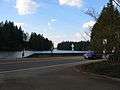
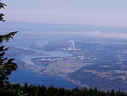 Aerial view of Camas, on the north side of the Columbia River | |
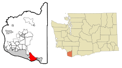 Location of Camas in Washington | |
| Coordinates: 45°35′28″N 122°24′44″W / 45.59111°N 122.41222°WCoordinates: 45°35′28″N 122°24′44″W / 45.59111°N 122.41222°W | |
| Country | United States |
| State | Washington |
| County | Clark |
| Area[1] | |
| • Total | 15.25 sq mi (39.50 km2) |
| • Land | 13.49 sq mi (34.94 km2) |
| • Water | 1.76 sq mi (4.56 km2) |
| Elevation | 75 ft (23 m) |
| Population (2010)[2] | |
| • Total | 19,355 |
| • Estimate (2015)[3] | 21,846 |
| • Density | 1,434.8/sq mi (554.0/km2) |
| Demonym(s) | Camasonian[4] |
| Time zone | UTC-8 (Pacific (PST)) |
| • Summer (DST) | UTC-7 (PDT) |
| ZIP code | 98607 |
| Area code | 360 |
| FIPS code | 53-09480 |
| GNIS feature ID | 1512059[5] |
| Website | City of Camas |
Camas /ˈkæməs/ is a city in Clark County, Washington, with a population of 19,355 at the 2010 census.[6] The east side of town borders the city of Washougal, Washington, and the west side of town borders Vancouver, Washington. Camas lies along the Washington side of the Columbia River, across from Troutdale, Oregon, and is part of the Portland metropolitan area.
One of the major geographical features of the city is Prune Hill. Prune Hill is an extinct volcanic vent and is part of the Boring Lava Field of northwest Oregon and southwest Washington.[7]
History
Officially incorporated on June 18, 1906, the city is named after the camas lily, a plant with an onion-like bulb prized by Native Americans. At the west end of downtown Camas is a large Georgia-Pacific paper mill from which the high school teams get their name, "the Papermakers". A paper mill was first established in the city in 1883 with the support of Henry Pittock, a wealthy entrepreneur from England who had settled in Portland, Oregon, where he published The Oregonian.[8]
Pittock's LaCamas Colony bought 2600 acres in 1883, forming the Columbia River Paper Company the following year to begin production in 1885, before merging with Oregon City's Crown Paper Company to form Crown Columbia Paper in 1905. Converting from steam to electricity in 1913, it then merged with Willamette Paper in 1914 and then again in 1928 with Zellerbach Paper to become the largest paper company on the west coast, Crown Zellerbach. Changing from newsprint to toilet tissue in 1930, it temporarily produced shipyard parts during the second world war. In 1950 it was the first factory to produce folded paper napkins.[9] "Crown Z" was the area's biggest employer in 1971, with 2,643 of approximately 3,700 Clark County paper-mill workers. Various other mergers took place, until Georgia-Pacific's mill was the sole property of Koch Industries. In 2018, Koch announced plans to lay off approximately 200-300 workers, shutting down all equipment related to communications paper, fine paper conversion and pulping operations.[10]
The city is about 20 miles (32 km) east of Portland. Historically, the commercial base of the city was almost solely the paper mill; however, the diversity of industries has been enhanced considerably in recent years by the influx of several white-collar, high-tech companies. These include Hewlett-Packard, Sharp Microelectronics, Linear Technology, WaferTech and Underwriters Labs. Annual events include the summer "Camas Days", as well as other festivals and celebrations.
Geography
According to the United States Census Bureau, the city has a total area of 15.25 square miles (39.50 km2), of which, 13.49 square miles (34.94 km2) is land and 1.76 square miles (4.56 km2) is water.[1]
There are numerous bodies of water within the city limits, including: Lacamas Lake, Lacamas Creek, Round Lake, Fallen Leaf Lake, Tug Lake, the Washougal River, and the Columbia River.
Public parks
There are numerous parks in Camas and within the Camas area, including:
- Crown Park
- Dorothy Fox Park
- Fallen Leaf Park
- Forest Home Park
- Goot Park
- Grass Valley Park
- Heritage Park
- Lacamas Park
- Louis Bloch Park
- Oak Park
- Prune Hill Sports Park
- Skate Park
Lacamas Park
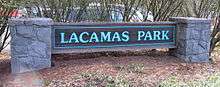
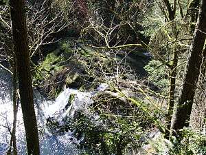
Lacamas Park encompasses Round Lake and runs against SR 500 on its west side. Across SR 500 is Lacamas Lake. The park is open year-round from 7 a.m. to dusk and includes barbecues, a play ground, trails around the park and lake, and access to the Camas Potholes.
The park features a network of trails which lead to the Camas Potholes and the Camas lily fields. A 1.2-mile (1.9 km) trail that loops around Round Lake starts and finishes near the parking lot. The park is a popular destination for Geocachers, as it contains numerous caches scattered around the park. Young children may play in a small playground on the west side of the park. Tables are provided for picnicking, as are waste receptacles designed to receive hot coals from grilling. Bathrooms are available on a seasonal basis only.
Heritage Park
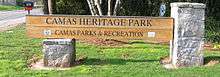
Heritage Park has facilities for launching boats into Lacamas Lake, a playground for young children, lots of open field, and small trails through the trees. The parking lot is very large and includes numerous long parking stalls to accommodate vehicles with trailers.
Demographics
| Historical population | |||
|---|---|---|---|
| Census | Pop. | %± | |
| 1890 | 417 | — | |
| 1910 | 1,125 | — | |
| 1920 | 1,843 | 63.8% | |
| 1930 | 4,230 | 129.5% | |
| 1940 | 4,433 | 4.8% | |
| 1950 | 4,725 | 6.6% | |
| 1960 | 5,666 | 19.9% | |
| 1970 | 5,790 | 2.2% | |
| 1980 | 5,681 | −1.9% | |
| 1990 | 6,442 | 13.4% | |
| 2000 | 12,534 | 94.6% | |
| 2010 | 19,355 | 54.4% | |
| Est. 2016 | 22,449 | [11] | 16.0% |
| U.S. Decennial Census[12] 2015 Estimate[3] | |||
2010 census
As of the census[2] of 2010, there were 19,355 people, 6,619 households, and 5,241 families residing in the city. The population density was 1,434.8 inhabitants per square mile (554.0/km2). There were 7,072 housing units at an average density of 524.2 per square mile (202.4/km2). The racial makeup of the city was 87.4% White, 1.0% African American, 0.6% Native American, 6.0% Asian, 0.2% Pacific Islander, 1.2% from other races, and 3.6% from two or more races. Hispanic or Latino of any race were 4.1% of the population.
There were 6,619 households of which 46.5% had children under the age of 18 living with them, 65.7% were married couples living together, 8.9% had a female householder with no husband present, 4.6% had a male householder with no wife present, and 20.8% were non-families. 16.2% of all households were made up of individuals and 4.9% had someone living alone who was 65 years of age or older. The average household size was 2.91 and the average family size was 3.27.
The median age in the city was 36.9 years. 31.1% of residents were under the age of 18; 6.5% were between the ages of 18 and 24; 27.1% were from 25 to 44; 26.8% were from 45 to 64; and 8.7% were 65 years of age or older. The gender makeup of the city was 49.6% male and 50.4% female.
2000 census
As of the census of 2000, there were 12,534 people, 4,480 households, and 3,422 families residing in the city. The population density was 1,149.3 people per square mile (443.6/km²). There were 4,736 housing units at an average density of 434.3 per square mile (167.6/km²). The racial makeup of the city was 92.01% White, 0.69% African American, 0.69% Native American, 3.41% Asian, 0.14% Pacific Islander, 0.80% from other races, and 2.26% from two or more races. Hispanic or Latino of any race were 2.86% of the population. 18.8% were of German, 11.3% English, 9.6% American, 8.2% Irish and 5.6% Norwegian ancestry according to 2000 Census.
There were 4,480 households out of which 42.6% had children under the age of 18 living with them, 63.9% were married couples living together, 8.5% had a female householder with no husband present, and 23.6% were non-families. 18.6% of all households were made up of individuals and 6.5% had someone living alone who was 65 years of age or older. The average household size was 2.78 and the average family size was 3.19.
In the city, the age distribution of the population shows 31.2% under the age of 18, 6.2% from 18 to 24, 32.5% from 25 to 44, 21.4% from 45 to 64, and 8.7% who were 65 years of age or older. The median age was 34 years. For every 100 females, there were 96.2 males. For every 100 females age 18 and over, there were 94.6 males.
The median income for a household in the city was $60,187, and the median income for a family was $64,885. Males had a median income of $51,470 versus $31,985 for females. The per capita income for the city was $27,267. About 4.4% of families and 5.4% of the population were below the poverty line, including 6.4% of those under age 18 and 4.7% of those age 65 or over.
Education
Sister cities
Camas has the following sister cities, according to and :
Notable people
- Michael R. Barratt, NASA astronaut
- Jaime Herrera Beutler, U.S. Representative
- Shane Chen, inventor and entrepreneur
- Alexa Efraimson, professional runner for Nike, bronze medalist at the 2013 World Youth Championships in Athletics
- Kenneth Fisher, Forbes columnist, financial author, money manager[14]
- Denis Hayes, environmental activist, coordinated first Earth Day
- Jimmie Rodgers, 1950s pop singer
- Taylor Williams, Major League Baseball player for Milwaukee Brewers, 2013 MLB Draft 4th round 122nd pick overall, 2013 All Mid-American Conference Baseball 1st Team Pitcher Kent State University
Gallery
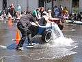 Competition is fierce at the Camas Days bathtub races
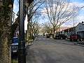 Downtown Camas, looking east
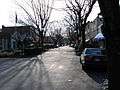 Downtown Camas, looking west
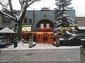 Liberty Theater in downtown Camas
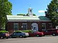 U.S. Post Office in Camas
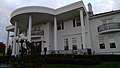 Bed and breakfast in Camas
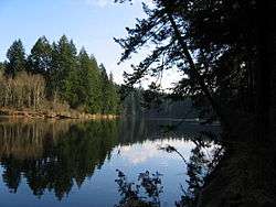
References
- 1 2 "US Gazetteer files 2010". United States Census Bureau. Archived from the original on 2012-07-14. Retrieved 2012-12-19.
- 1 2 "American FactFinder". United States Census Bureau. Retrieved 2012-12-19.
- 1 2 "Population Estimates". United States Census Bureau. Retrieved June 22, 2016.
- ↑ "Tweet from City of Camas account". 6 March 2017. Retrieved 12 August 2018.
- ↑ "US Board on Geographic Names". United States Geological Survey. 2007-10-25. Retrieved 2008-01-31.
- ↑ "2010 Census Redistricting Data (Public Law 94-171) Summary File". American FactFinder. United States Census Bureau. Archived from the original on 21 July 2011. Retrieved 16 September 2012.
- ↑ Boring Lava Field, vulcan.wr.usgs.gov
- ↑ Caldbick, John (8 February 2010). "Camas -- Thumbnail History". History Link. Retrieved 8 July 2017.
- ↑ "Timeline of Paper Mill's Presence in Camas". The Columbian. Vancouver, Washington. The Columbian. 1 February 2018. pp. A2.
- ↑ Brynelson, Troy (1 February 2018). "May Day: Paper Cuts. Layoffs at Georgia-Pacific mill in Camas to start May 1, affect 280 to 300 workers". The Columbian. Vancouver, Washington. The Columbian. pp. A1–A2.
- ↑ "Population and Housing Unit Estimates". Retrieved June 9, 2017.
- ↑ United States Census Bureau. "Census of Population and Housing". Archived from the original on May 12, 2015. Retrieved September 19, 2013.
- ↑ "US-Japan Sister Cities by State". Asia Matters for America. Honolulu, HI: East-West Center. Retrieved 20 November 2015.
- ↑ "Ken Fisher's Forbes 400 Profile". Forbes.
External links
| Wikimedia Commons has media related to Camas, Washington. |
| Wikivoyage has a travel guide for Camas. |
- Official website
- History of Camas at HistoryLink
- "Columbia Communities: Camas Table of Contents". Center for Columbia River History. Retrieved 2013-08-15.
- Camas Public Schools
Municipalities and communities of Clark County, Washington, United States | ||
|---|---|---|
| Cities | 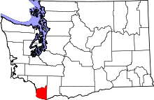 | |
| Town | ||
| CDPs | ||
| Other unincorporated communities | ||
| Footnotes | ‡This populated place also has portions in an adjacent county or counties | |
