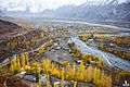
Yasin Valley
| Yasin Valley | |
|---|---|
| Valley | |
 Yasin Valley, Ghizer | |
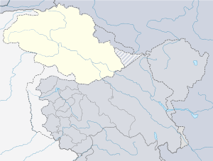 Yasin Valley Location in Pakistan  Yasin Valley Yasin Valley (Pakistan) | |
| Coordinates: 36°22′15″N 73°20′00″E / 36.37083°N 73.33333°ECoordinates: 36°22′15″N 73°20′00″E / 36.37083°N 73.33333°E | |
| Country |
|
| Province | Gilgit Baltistan |
| District | Ghizer District |
| Time zone | UTC+5 (PST) |
Yasin (یاسین Yāsīn), also known as Babaye-i-Yasen (بابائے یاسین) or Worshigum (ورشیگوم Worśigūm), is a high mountain valley in the Hindu Kush mountains, in the northwestern Ghizer District in Gilgit-Baltistan, northern Pakistan.[1][2] Yasin Tehsil is situated on its territory.
| Princely state |
|---|
| Individual residencies |
| Agencies |
|
| Lists |
History
Although sparsely populated, Yasin was of strategic importance because it leads to a high mountain pass, to Yarkhun in Chitral, and then to Broghol Pass, the Wakhan Corridor of Afghanistan and into Tajikistan. Thus, Yasin could have formed an invasion route from Czarist Russia into British India.
Early period
Yasin was originally ruled by the Khushwakhte dynasty, a collateral line of the Mughal sultans of Delhi, which came from Khorasan (Persia). The Rajas of Yasin were great warriors and fought against the Sikhs and the Dogras of Kashmir, but this house eventually lost power.
- c.1640 - c.1700 Shah Khuswaqt bin Mohammad Beg
- c.1700 Shah Alam
- c.1720 Shah Gahangir
- c.1740 Shah `Alamgir
- c.1750 Shah `Alam
- c.1760 Shah Badshah
- c.1780 - 1804 Mulk Aman (died 1804)
- 1804 - 1805 Kuwat Khan
- 1805 - 1828/29 Sulayman Shah (d. 1828/29)
- 1829 - 1830/40 Mir Aman
- 1841 - 1860 Ghauhar Aman (Gur Rahma) (born 1809 - d. 1860)
- 1860 - 1880 Ghulam Muhyiuddin
Chitral rule
From 1880, Yasin was under the suzerainty of the Maharaja of Kashmir, initially ruled by the Mehtars (princely rulers) of Chitral, until it got its own ruler again, now also styled Mehtar, in 1892.
Yasin Mehtars
- c.1892 - 1911 `Abd ar-Rahman Khan (1st time) (b. 1877 - d. 1948?)
- 1911 - 1912 Shahid al-Agham Khan (d. 1912)
- 1912 - 1922 Sifat Khan Bahadur (d. 1922)
- 1923 - 19. `Abd ar-Rahman Khan (2nd time) (s.a.).
Population
The primary languages of Yasin Valley are the (Khowar and Burushaski language). The Shina language is also spoken.
The majority of the people in Yasin are Ismailis, who lead their lives according to the Islamic principles more concerned with the imam of the time. Currently Aga Khan IV is the imam and spiritual leader of the Ismailis. However, other branches of both as Sunni and Shia Islam also live in Yasin.
Ethnically, the people of Yasin are of Burusho origin; however, there are the migrants from different parts of the country, mainly from Afghanistan.
The people of Yasin are known for their honesty, hard work and bravery.
Geography
Yasin is separated from the Ishkoman Valley by a high mountain pass. To reach Yasin one must take the Karakoram Highway north from Islamabad, and then turn left to reach Gupis in Ghizar. After Gupis, one continues northwest to reach the Yasin Valley.
The part of the valley where Khowar is spoken is known in the Shina language as Arinah.[3]
Villages
Administratively, Yasin constitutes Yasin Tehsil, which is part of Ghizer District. It is further divided into four local councils: Yasin, Sultanabad, Silgan and Thoi.
- Yasin consists of the villages of Chiliharang, Damalgan, Gindai, Noh, Morka, Atkash, Bujayot, Manichi, Thodass and Nazbar Valley. Thodass is the headquarters of this union council.
- Sultanabad union council consists of the villages of Chumarkhan, Taus, Barkhachi, Sultanabad (Met, Huyelti), Ghojalti, Sandi, Dalsandi and Qorqolti Valley. Taus is the headquarters of this union council.
- Selgaan union council consists of the villages of Barandass, Barkolti, Chilpi, Sheghetan, Hundoor, Terchet, Umalsat and Darkut, which leads to the Pass to Boroghol. Hundoor is the headquarters of this union council.
- Thoi Valley union council consists of the villages of Ghaingchel, Ishkaibar, Karimabad, Dalkoi, Dapis, Shamsabad(Druch), Harp, Rahimabad, Kuno, Shot, Chiryat, Ishqamdass, Draskin, Nalti, Dass, Thelti, Ishqamghoro, Mahrakabun and Mushibarnala, which leads to Yarkhun Pass. Harp is the headquarters of this union council.
Passes
The Darkut Pass connects Yasin with Wakhan and Chitral, height 4267 meters or 14000 feet, Buroghul pass connect Yasi with Brughol, height 3798 meters, or 12460 feet. while the Thoi Pass connects Yasin to Yarkhun Chitral, height 4690 meters or 15387 feet. Assumber pass connects Yasin to Ishkomen. Darkot Pass is an historical pass which has been labelled as a restricted zone by the government of Pakistan. This pass used to be the shortest means of communication between the Oxus and Indus. Most tourism is along the Assumbur Pass to the Ishqamen valley. one pass is from Darkot yasin to Thoi. Three passes from Nazbar yasin connect to Mastuj Chitral, height 5009 meters or 16434 feet, one pass from Bujayote Nala to Bawoshter Ghizat Shamaran, one other pass from Khaimet bar to Chitral (sources Aina e Dardistan By Hidayat ullah Akhter, edited by Javed sajid Sultanabad Yasin)
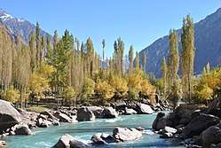
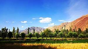
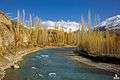
Gallery
 Sandi Village
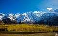

References
- ↑ "Yasin Valley in Ghizer District". Pamirtimes.net. Retrieved 8 September 2018.
- ↑ "Yasin Valley, Ghizer District, Gilgit-Baltistan". www.merawatan.pk. Retrieved 8 September 2018.
- ↑ Grierson, George A. (1919). Linguistic Survey of India. Volume VIII , Part 2, Indo-Aryan family. North-western group. Specimens of the Dardic or Piśācha languages (including Kāshmiri). Calcutta: Office of the Superintendent of Government Printing, India. p. 133.