Jose Abad Santos Avenue
| ||||
|---|---|---|---|---|
|
Olongapo–Gapan Road Gapan–San Fernando–Olongapo Road | ||||
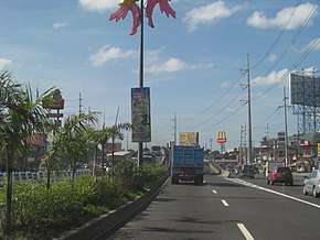 Driving eastbound through San Fernando, Pampanga | ||||
| Route information | ||||
| Length | 118 km (73 mi) | |||
| Component highways | ||||
| Major junctions | ||||
| East end |
| |||
| ||||
| West end |
| |||
| Location | ||||
| Provinces | Nueva Ecija, Pampanga, Bataan, Zambales | |||
| Major cities | Gapan, San Fernando, Olongapo | |||
| Highway system | ||||
|
Roads in the Philippines
| ||||
.svg.png)
Jose Abad Santos Avenue, also known as Olongapo–Gapan Road and Gapan–San Fernando–Olongapo Road is a 118-kilometre (73 mi) major highway spanning the provinces of Nueva Ecija, Pampanga, Bataan and Zambales in Central Luzon, Philippines. The highway is designated as the National Route 3 (N3) of the Philippine highway network.[1]
Etymology
Jose Abad Santos Avenue was named after the late Chief Justice Jose Abad Santos, a Kapampangan born in San Fernando on February 19, 1886. The avenue was formerly called Olongapo–Gapan Road and Gapan–San Fernando–Olongapo Road. The name was changed in line with Republic Act No. 9477 signed by former president Gloria Macapagal Arroyo on May 22, 2007. Nowadays, the avenue is commonly referred to by its acronym JASA, however, its old name is still used.[2]
History
.jpg)
Jose Abad Santos Avenue traces its roots to the pre-colonial period. The Kapampangan empire expanded their trades throughout Central Luzon, forcing them to create roads adjacent to the Pampanga River. Since Nueva Ecija, Bulacan and Rizal (Metro Manila) are readily accessible because the road networks to that locations exist, the empire could not access the province of Zambales and Bataan. Through the years, they developed land tracks accessible by foot and small wagons pulled by horses.
When the Spanish Colonials came in the Philippines, they developed the road built by the old empire. They widened the road, constructed wooden bridges, and connected it to the Olongapo, a very vital location which emabled them to easily access the Subic Bay, the site of their Naval Base.
When the Americans came, they paved the Olongapo Gapan Road and constructed concrete bridges, the longest is the one that traverses Great Pampanga River. These actions enabled them to connect their Air Field in Clark and their Naval Base in Subic Bay. Greater improvements on the road was made on this period.
When the World War II started, the Olongapo Gapan Road was crippled, halting the transportation throughout the entire span of the road. The Japanese bombed the road to stop the Americans and Filipino in the fortification of different bases which spans through the Central Luzon.
After the end of the War, the Philippine Government rehabilitated and repaired the whole road, paving all of the 118-kilometer long highway. New bridges was constructed, shoulders were improved and added some facilities.
During the Mount Pinatubo eruption in 1991, some portions of a highway, especially its Bacolor and Magliman, San Fernando section, were buried in lahar and many bridges were destroyed. A year after the disaster, these sections were rehabilitated, which involved building new roads and bridges.
Today, the Olongapo Gapan Road, now called the Jose Abad Santos Avenue, designated as the National Road 3 by the Strong Republic Nautical Highway System, is the most significant toll-free road that connects Nueva Ecija, Pampanga, Bataan and Zambales.
Route description
The road passes to Gapan, San Isidro and Cabiao in Nueva Ecija, Santa Ana, Arayat, Mexico, City of San Fernando, Bacolor, Guagua, and Lubao in Pampanga, Hermosa and Dinalupihan in Bataan, and finally to the city of Olongapo in Zambales.[3] Various high voltage overhead power lines, most notably the Hermosa-Duhat-Balintawak and Hermosa-Calaguiman transmission lines of National Grid Corporation of the Philippines (NGCP), utilize the highway right of way from San Fernando Exit of North Luzon Expressway (NLEX) to Layac Junction for accessibility to work vehicles and also due to scarcity of land for dedicated right of way.
Gapan to San Fernando
The road starts on Pan-Philippine Highway (Route 1 / Asian Highway 26) at the city of Gapan in Nueva Ecija. It enters San Isidro where the road turns westward. A few meters is Cabiao where the road continues straightforward, again turning westward then eastward, entering Pampanga, and passes through Pampanga River. It then passes through residential areas and institutions within the municipalities of Arayat, Santa Ana, and Mexico before entering San Fernando. The SM City Pampanga and Robinson malls can be seen on a boundary between Mexico and City of San Fernando. It intersects with NLEX after passing these two malls. It crosses MacArthur Highway through Dolores Flyover, continues on a straight route, with its city proper being visible from the highway, and there is another flyover named Lazatin Flyover. A few meters after the flyover is San Fernando Central Transport Terminal. The city's welcome sign can be located on this portion and after it, the highway enters Bacolor.
Bacolor to Olongapo
Upon entering Bacolor, the road turns eastward and passes through the lahar-filled Pasig-Potrero River. It passes through Bacolor town proper, with its parish church being visible from the highway and a restaurant named Apag Marangle. It continues on a straight direction, intersects with Guagua-Santa Rita Provincial Road and San Antonio-Siran Road, turns westward, and enters Lubao after passing the second road mentioned before. It continues straightforward, passing through residential areas and establishments within the municipality and parallels the Lubao Old National Road. It then passes through Porac Gumain River, Barangays Sta. Cruz, Lourdes, San Isidro, and Prado Siongco before entering Bataan through the Pampanga Welcome marker. The Lubao Bypass Road parallels the highway starting on a said river until Barangay Lourdes in Lubao. The road continues staightforward and after a few meters, it enters Dinalupihan. The highway then passes through Layac Junction where it turns right. It will pass on various establishments and residential areas within the municipality. It turns westward and intersects with Subic-Clark-Tarlac Expressway (SCTEX). It then intersects with the said expressway, parallels into it, continues on a straight direction, passes through barangays San Benito, Colo, Naparing, Happy Valley, Roosevelt National Park Protected Area, and Dinalupihan Exit. It enters Zambales a few meters after the said exit and continues on a zigzag pattern before passing through residential areas within Olongapo. The road then continues to National Highway (Route 306) at its terminus.
Intersections
Intersections are numbered by kilometre post, with Rizal Park in Manila designated as kilometre 0.
| Province | City/Municipality | km | mi | Destinations | Notes |
|---|---|---|---|---|---|
| Nueva Ecija | Gapan | Eastern terminus. | |||
| Pampanga | San Fernando | ||||
| Bataan | Dinalupihan | ||||
| Hermosa | |||||
| Olongapo | Ulo ng Apo roundabout intersection. Western terminus. | ||||
| 1.000 mi = 1.609 km; 1.000 km = 0.621 mi | |||||
Landmarks
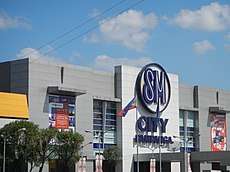
The Jose Abad Santos Avenue spans for about 118-kilometer, thus, many establishments and landmarks are built along side the highway. This landmarks are malls, historical sites, government facilities, and many more other establishments. Two major shopping malls along the road are SM City Pampanga, the second largest mall in Northern and Central Luzon, and Robinson's Star Mills.
See also
References
- ↑ "Jose Abad Santos Avenue". ph.geoview.info. Retrieved 2017-07-19.
- ↑ "Republic Act No. 9477 | GOVPH". Official Gazette of the Republic of the Philippines. Retrieved 2017-07-19.
- ↑ "Gapan-San Fernando-Olongapo Road: San Fernando". Caught (up) in traffic. 2012-01-18. Retrieved 2017-07-19.
| National primary roads |
| |||||||
|---|---|---|---|---|---|---|---|---|
| National secondary roads |
| |||||||
See also: Philippine expressway network | ||||||||