Terskey Alatau
| Terskey Ala-Too | |
|---|---|
|
Тескей Ала-Тоо | |
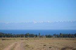 Terskey Alatau range seen from across Issyk Kul Lake | |
| Highest point | |
| Peak | Karakol Peak |
| Elevation | 5,216 m (17,113 ft) |
| Coordinates | 42°10′N 78°28′E / 42.167°N 78.467°ECoordinates: 42°10′N 78°28′E / 42.167°N 78.467°E |
| Dimensions | |
| Length | 354 km (220 mi) E-W |
| Width | 40 km (25 mi) N-S |
| Geography | |
 Terskey Ala-Too | |
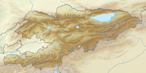
| Country | Kyrgyzstan |
| State/Province | Issyk-Kul Region |
The Terskey Alatau or Terskey Ala-Too (Kyrgyz: Тескей Ала-Тоо, [teskéj ɑlɑtoːsú]) is a mountain range in the Tian Shan mountains in Kyrgyzstan. It stretches south and southeast of Lake Issyk Kul, from the river Joon Aryk near Kochkor in the west to the far northeastern part of Kyrgyzstan. The length of the range is 354 km and the highest peak is Karakol Peak (5,216 m).[1] Another high peak is Boris Yeltsin Peak (5,168 m).
Geology
Teskey Ala-Too is composed of granites and granodiorites of Caledonian, and granites, metamorphic schists, quartzites, sandstones, and limestones of Paleozoic.
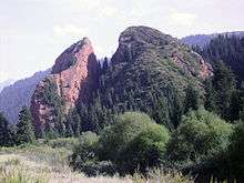
Broken Heart Rock, in the Jety-Oguz Valley in the Terskey Ala-Too
References
External links

This article is issued from
Wikipedia.
The text is licensed under Creative Commons - Attribution - Sharealike.
Additional terms may apply for the media files.