District of Columbia Route 295
| ||||
|---|---|---|---|---|
 | ||||
| Route information | ||||
| Maintained by DC DOT | ||||
| Length | 4.29 mi[1] (6.90 km) | |||
| Major junctions | ||||
| South end |
| |||
| North end |
| |||
| Highway system | ||||
| ||||

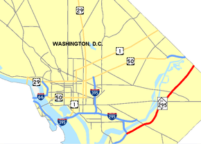
District of Columbia Route 295 (DC 295), also known as the Anacostia Freeway as well as the Kenilworth Avenue Freeway north of East Capitol Street, is a freeway in the District of Columbia, and currently the only signed numbered route in the District that is not an Interstate Highway or U.S. Highway. The south end is at the junction of Interstate 295 (I-295), I-695 and the southern end of the 11th Street Bridges; its north end is at the border with Maryland where it continues as Maryland Route 201 (MD 201) and then the Baltimore–Washington Parkway (unsigned Maryland Route 295).
Route description
_at_milepost_0.4_in_Washington%2C_D.C..jpg)
DC 295 starts at a split from I-295 and I-695 at the 11th Street Bridges in Anacostia. From there, it continues northeasterly along the Anacostia River to the DC-Maryland border. DC 295, I-295, and the Baltimore–Washington Parkway, while administratively distinct, form one continuous freeway linking the southern portion of the Capital Beltway to Baltimore. Mileposts continue the sequence of I-295 from the split. Frontage roads near the north end are known as Kenilworth Avenue, which is the name of MD 201 after splitting from the main freeway. DC 295 is part of the National Highway System.
The roadway between Benning Road and the District Line was built on the right of way of the former Benning streetcar line, which is why parts of it are narrow with short entrances and exits. Until May 1, 1949, streetcar routes 10 and 12 operated from downtown to Deane Avenue. Route 10 continued to Kenilworth, just inside the District Line. Route 12 turned off and ran to Seat Pleasant. That right of way was later paved and it is now called Nannie Helen Burroughs Avenue.
I-295 officially ended on a ramp to the 11th Street Bridge. For years the road between there and the District Line was often referred to as Route 295 even though it bore no such markings. It was not long after parts of the Baltimore-Washington Parkway in Maryland were numbered MD 295 that Washington numbered their portion as DC 295.
Exit list
Exit numbers were added in 2014 as part of the 11th Street Bridges reconstruction.
| District/state | County | Location | mi[1] | km | Exit | Destinations | Notes |
|---|---|---|---|---|---|---|---|
| District of Columbia | City of Washington | 0.00 | 0.00 | 1A | Exit 5B on I-295 | ||
| 1B | Northbound movements via I-295 exit 5A | ||||||
| 1C | MLK Jr. Avenue SE / 11th Street SE | Northbound movements via I-295 exit 5C | |||||
| 0.83 | 1.34 | Pennsylvania Avenue east – Andrews AFB | Signed as exit 1A northbound | ||||
| 1B | Pennsylvania Avenue west | No southbound exit | |||||
| 2.23 | 3.59 | — | East Capitol Street west | No northbound exit | |||
| 2.59 | 4.17 | — | River Terrace | Southbound exit only | |||
| 2.79 | 4.49 | — | Benning Road west / Foote Street – RFK Stadium | Left exit and entrance northbound; Foote St. not signed northbound | |||
| 3.30 | 5.31 | — | Burroughs Avenue / Minnesota Avenue | ||||
| 3.90 | 6.28 | — | Polk Street | Northbound exit only | |||
| D.C.–Maryland line | City of Washington– Prince George's County line | 4.29 | 6.90 | — | Quarles Street / Eastern Avenue | Northbound exit and southbound entrance | |
| Continuation into Maryland | |||||||
1.000 mi = 1.609 km; 1.000 km = 0.621 mi
| |||||||
See also
References
- 1 2 "National Highway Planning Network GIS data". FHWA. August 2005. Retrieved 2007-07-09.
External links
Route map:

- Steve Anderson's DCroads.net: Anacostia Freeway (I-295 and DC 295)
- Steve Anderson's DCroads.net: Kenilworth Avenue Freeway (DC 295)