Gongbo'gyamda County
| Gongbo'gyamda County 工布江达县 • ཀོང་པོ་རྒྱ་མདའ་རྫོང་། | |
|---|---|
| County | |
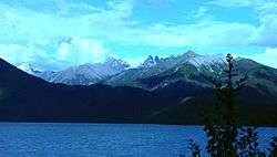 Basum Tso | |
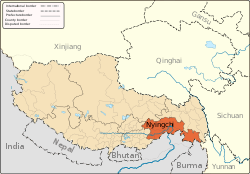
.png) Location of Gongbo'gyamda County (red) in Nyingchi City (yellow) and the Tibet Autonomous Region | |
 Gongbo'gyamda Location of the seat in the Tibet A.R. | |
| Coordinates: 30°23′38″N 93°27′10″E / 30.39389°N 93.45278°E | |
| Country | People's Republic of China |
| Autonomous region | Tibet |
| Prefecture-level city | Nyingchi |
| Time zone | UTC+8 (China Standard) |
Gongbo'gyamda County (Tibetan: ཀོང་པོ་རྒྱ་མདའ་རྫོང་, Wylie: kong po rgya mda' rdzong, ZYPY: Gongbo'gyamda Zong ; simplified Chinese: 工布江达县; traditional Chinese: 工布江達縣; pinyin: Gōngbùjiāngdá Xiàn) is a county of the Nyingtri City in the Tibet Autonomous Region, lying approximately 275 km (171 mi) east of Lhasa at its central point. Its main geographical feature is Basum Tso, a green lake of some 3,700 m (12,100 ft) above sea level.
History
In 1587, Gyampo Monastery was established. Subbsequently, a town named "Gyamda", meaning "valley outlet of Gyampo", was developed near the monastery. The region was originally under control of Derge Gyalpos. After the Qing Dynasty took over Derge, the region was managed by the Tibetan Government as Gyamda Dzong. In 1960, Gyamda Dzong merged with West Dengke Dzong to form the modern Gongbo'gyamda Dzong.[1]
Geography
Gongbo'gyamda County is located in the east of the Tibet Autonomous Region, to the south of the Nyainqentanglha Mountains, to the north of the Yarlung Tsangpo River and in the area of the middle branches of the Nyang River. With a population of 22,000, the county covers an area of 12,886 square kilometres. The average altitude of the county is 3,500 metres above sea level. The Gonggo Lake, with a total area of 26 square kilometres, is a famous lake.
Transport
Economy and reserves
Water resources is abundant in Gongbo'gyamda County. The species of animals include leopard, red deer, black bear, brown bear, otter, monkey and black-necked crane, etc. There are almost a hundred of species of plants in the county, such as aweto, fritillaria and snow lotus, etc.
Block raising is the main industry of the county. The Sichuan-Tibet Highway crosses the county. The total length of all roads reaches 380 km (240 mi).
References
Coordinates: 30°23′38″N 93°27′10″E / 30.39389°N 93.45278°E