Copeland Bridge
| Copeland Covered Bridge | |
|---|---|
 | |
| Coordinates | 43°13′16″N 74°06′04″W / 43.221°N 74.101°WCoordinates: 43°13′16″N 74°06′04″W / 43.221°N 74.101°W |
| Crosses | Beecher Creek |
|
Copeland Covered Bridge | |
 | |
  | |
| Location | North Shore Rd., over Beecher Cr., Edinburg, New York |
|---|---|
| Coordinates | 43°13′15″N 74°6′2″W / 43.22083°N 74.10056°WCoordinates: 43°13′15″N 74°6′2″W / 43.22083°N 74.10056°W |
| Area | 1 acre (0.40 ha) |
| Built | 1879 |
| Built by | Copeland, Arad |
| NRHP reference # | 98000998[1] |
| Added to NRHP | August 6, 1998 |
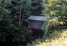
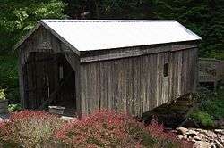
Copeland Bridge, also known as Copeland Farm Bridge or Copeland Covered Bridge is a wooden covered bridge over Beecher Creek in the town of Edinburg in Saratoga County, New York. It was built in 1879, and is a small, timber framed, queenpost truss bridge with a gable roof. It has a 30-foot span carried on fieldstone abutments.[2]:3
It was listed on the National Register of Historic Places in 1998.[1]
References
- 1 2 National Park Service (2010-07-09). "National Register Information System". National Register of Historic Places. National Park Service.
- ↑ "Cultural Resource Information System (CRIS)" (Searchable database). New York State Office of Parks, Recreation and Historic Preservation. Retrieved 2015-12-01. Note: This includes Raymond W. Smith (June 1998). "National Register of Historic Places Registration Form: Copeland Covered Bridge" (PDF). Retrieved 2015-12-01. and Accompanying photographs
External links
- Copeland Covered Bridge photos and more, at The Historical Marker Database
- Copeland Farm Bridge, at New York State Covered Bridge Society
- Copeland Bridge, at Covered Bridges of the Northeast USA
| Topics |   | |
|---|---|---|
| Lists by county |
| |
| Lists by city | ||
| Other lists | ||
| ||
This article is issued from
Wikipedia.
The text is licensed under Creative Commons - Attribution - Sharealike.
Additional terms may apply for the media files.