Cameron Highlands District
| Cameron Highlands District | |||||||||||||||||||||||||
|---|---|---|---|---|---|---|---|---|---|---|---|---|---|---|---|---|---|---|---|---|---|---|---|---|---|
|
| |||||||||||||||||||||||||
| Daerah Cameron Highlands | |||||||||||||||||||||||||
| Other transcription(s) | |||||||||||||||||||||||||
| • Jawi |
تانه تيڠڬي كمايرون (Tanah Tinggi Cameron) | ||||||||||||||||||||||||
| • Chinese | 金马仑高原县 | ||||||||||||||||||||||||
| • Tamil | கேமரன் மலை | ||||||||||||||||||||||||
 Location of Cameron Highlands District in Pahang | |||||||||||||||||||||||||
 Cameron Highlands District Location of Cameron Highlands District in Malaysia | |||||||||||||||||||||||||
| Coordinates: 4°30′N 101°30′E / 4.500°N 101.500°ECoordinates: 4°30′N 101°30′E / 4.500°N 101.500°E | |||||||||||||||||||||||||
| Country |
| ||||||||||||||||||||||||
| State |
| ||||||||||||||||||||||||
| Seat | Tanah Rata | ||||||||||||||||||||||||
| Local area government(s) | Cameron Highlands District Council | ||||||||||||||||||||||||
| Government | |||||||||||||||||||||||||
| • District officer | Ahmad Daud[1] | ||||||||||||||||||||||||
| Area[2] | |||||||||||||||||||||||||
| • Total | 712 km2 (275 sq mi) | ||||||||||||||||||||||||
| Population (2010)[3] | |||||||||||||||||||||||||
| • Total | 33,278 | ||||||||||||||||||||||||
| • Density | 47/km2 (120/sq mi) | ||||||||||||||||||||||||
| Time zone | UTC+8 (MST) | ||||||||||||||||||||||||
| • Summer (DST) | UTC+8 (Not observed) | ||||||||||||||||||||||||
| Postcode | 39xxx | ||||||||||||||||||||||||
| Calling code | +6-05 | ||||||||||||||||||||||||
| Vehicle registration plates | C | ||||||||||||||||||||||||
| |||||||||||||||||||||||||
.jpg)

_female_(8732049440).jpg)


The Cameron Highlands (Malay: Tanah Tinggi Cameron, Chinese: 金马崙高原, Tamil: கேமரன் மலை) is a district in Pahang, Malaysia occupying an area of 712.18 square kilometres (274.97 sq mi). To the north, its boundary touches that of Kelantan; to the west, it shares part of its border with Perak.
Situated at the northwestern tip of Pahang, the “Camerons” is approximately 90 kilometres (56 mi) from Ipoh, roughly 200 kilometres (120 mi) from Kuala Lumpur or about 355 kilometres (221 mi) from Kuantan, the capital of Pahang. It is the smallest municipality in the state.
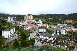
Surveyed by geologist William Cameron [7][8] in 1885, the outpost consists of three mukims (subdistricts), namely Ringlet, Tanah Rata and Ulu Telom.[9] Its eight settlements are Ringlet, Tanah Rata (the administrative centre), Brinchang, the Bertam Valley, Kea Farm, Tringkap, Kuala Terla and Kampung Raja. All are nestled at elevations ranging from 800 metres (2,600 ft) to 1,603 metres (5,259 ft) above sea level. [10]
Developed in the 1930s, the tableland is one of the oldest tourist spots in Malaysia. Apart from its tea estates, [11] the plateau is also noted for its cool weather, orchards, nurseries, farmlands, waterfalls, rivers, lakes, wildlife, mossy forest, golf course, hotels, places of worship, bungalows, Land Rovers, museum and its aborigines (Orang Asli).
Background
The Cameron Highlands were named after William Cameron, a British explorer and geologist [12] who was commissioned by the then colonial government to map out the Pahang-Perak border area in 1885.[13][11][14]
In a statement concerning his mapping expedition, Cameron mentioned he saw “a sort of vortex on the mountains, while for a (reasonably) wide area we have gentle slopes and plateau land.”[15]

When approached, Sir Hugh Low, the Resident of Perak (1887–1889), expressed the wish of developing the region into a "sanatorium, health resort and open farmland”. A narrow path to “Cameron’s Land” was then carved through the jungle. Nothing much happened after that.[16]
Forty years later, the tableland was given another review when Sir George Maxwell (1871–1959) visited the locale to see if it could be turned into a resort. He spent about nine days surveying the territory.[17] On his return from the highlands, Maxwell described the terrain as being “somewhat oval in shape.”[17] After comparing it with Nuwara Eliya in Sri Lanka and Baguio in the Philippines,[17] he decreed that the site should be developed into a hill station.[18]
In mid-1925, an Agricultural Experiment Station was set up to confirm if cinchona, tea, coffee, fruits and vegetables could be grown at the district. In December 1925, a superintendent was appointed to supervise the 200-acre (81-ha) plantation on Mount Beremban.[19] While research at the station was being carried out, the colonial office assigned Captain C.C. Best, a surveyor from the Federated Malay States to trace the Telom River (Malay: Sungei Telom). The Annual Report of the Survey Department (1925) states he explored “the Ulu of the Telom which was the actual area traversed by Cameron” and “he went first to what is known as Cameron Highlands to obtain a basis of comparison and from there crossed over into the Telom Valley. He made a reconnaissance map of the head waters of the Telom and his exploration has established definitely that the area at the Ulu of the Bertang (Bertam?) is incomparably the most suitable for development.” [20]
This report, coupled with the confirmation that tea could also be grown, gave the British the motivation to develop the place.
In 1926,[20] a development committee was formed to zone off the moorlands for agriculture, defence, administration, housing and recreation. Later, a three-million-dollar road[21] was constructed from Tapah to the highlands. It started from the 19th mile Tapah-Pahang Road and ended at Ginting “B” (Tanah Rata).[21]
The three-year contract was awarded to Messrs. Fogden, Brisbane and Company.[21] The first installment of $250,000 was made in 1926.[22] The project commenced on 1 January 1928; it was completed on Friday, 14 November 1930 – 47 days ahead of schedule.[21]
The building of the road was a challenge: the crew not only had to deal with the weather; they also had to cope with the risk of being struck down with malaria. During the construction stage, the manning level varied from 500 to 3,000 workers. Throughout the contract, 375 employees were hospitalised for fever.[21]
The Straits Times, 7 June 1928.[23]
The biggest problem faced by the contractor was the haulage of heavy equipment from the lowlands to the upper reaches. This setback was overcome with the use of steam-driven locomotives which were designed for work on steep gradients.[11][24]
When the road was opened in 1931,[25] the British and the locals moved in to settle on the slopes of the mountain. They were soon followed by tea planters and vegetable growers who found the climate to be suitable for the growing of their crops.
On 1 July 1931, Cameron Highlands was made an autonomous sub-district under Kuala Lipis, with its own Deputy District Officer subordinate to the Lipis District Officer.[26]
By the mid-1930s, there was a notable improvement in the constituency: it now had a six-hole golf course,[27] several cottages, three inns, a police post, two boarding schools, a military camp, a dairy, a horse spelling ranch, nurseries, vegetable farms, tea plantations, a Government Rest House and an Agricultural Experiment Station.
The domain continued to grow until the outbreak of the Second World War. During the Japanese Occupation of the Malay Peninsula (1942–1945), there was hardly any development in the area. When the Japanese withdrew in August 1945, the place underwent a transformation. This, however, came to a halt during the Malayan Emergency (1948–1960). When the conflict ended, “Cameron’s Land” experienced a constant change in its landscape. Today, the haven is not only the biggest and best known of Malaysia’s hill stations; it is also the highest point in Peninsular Malaysia accessible by car.[28]
Climate
The climate of the Cameron Highlands is on the border between a tropical rainforest climate (Köppen climate classification Af) and a subtropical highland climate (Köppen climate classification Cfb). Its mean annual temperature is 18 °C (64 °F). During the day, the temperature seldom rises over 25 °C (77 °F); at night, it can drop to as low as 9 °C (48 °F) at the higher reaches.[29] Its yearly precipitation is more than 2,700 mm (110 in). The lowest temperature recorded was on Wednesday, 1 February 1978 – the temperature dropped to 7.8 °C (46.0 °F) at an altitude of 1,471.6 metres above sea level.[30]
| Climate data for Cameron Highlands | |||||||||||||
|---|---|---|---|---|---|---|---|---|---|---|---|---|---|
| Month | Jan | Feb | Mar | Apr | May | Jun | Jul | Aug | Sep | Oct | Nov | Dec | Year |
| Average high °C (°F) | 21.4 (70.5) |
22.3 (72.1) |
23.0 (73.4) |
23.3 (73.9) |
23.2 (73.8) |
22.8 (73) |
22.3 (72.1) |
22.0 (71.6) |
21.9 (71.4) |
21.8 (71.2) |
21.7 (71.1) |
21.1 (70) |
22.2 (72) |
| Average low °C (°F) | 14.6 (58.3) |
14.6 (58.3) |
15.2 (59.4) |
15.8 (60.4) |
16.1 (61) |
15.6 (60.1) |
15.2 (59.4) |
15.3 (59.5) |
15.3 (59.5) |
15.3 (59.5) |
15.3 (59.5) |
14.9 (58.8) |
15.3 (59.5) |
| Average rainfall mm (inches) | 95.3 (3.752) |
144.0 (5.669) |
220.6 (8.685) |
257.5 (10.138) |
273.5 (10.768) |
174.4 (6.866) |
173.2 (6.819) |
229.5 (9.035) |
278.4 (10.961) |
373.0 (14.685) |
316.8 (12.472) |
209.8 (8.26) |
2,746 (108.11) |
| Average rainy days (≥ 1.0 mm) | 11 | 11 | 16 | 17 | 18 | 13 | 14 | 16 | 20 | 23 | 21 | 17 | 197 |
| Source: World Meteorological Organization[31] | |||||||||||||
Demographics
| Ethnic groups in Cameron Highlands District (2010 census) | ||
|---|---|---|
| Ethnicity | Population | Percentage |
| Chinese | 13,099 | 39.4% |
| Bumiputera | 12,989 | 39.0% |
| Indian | 6,988 | 21.0% |
| Others | 202 | 0.6% |
| Total | 33,278 | 100% |
The district has a diverse population of 33,278 people. It comprises Chinese (13,099), Bumiputeras (12,989) — Malays (7,321); others (5,688) — Indians (6,988), non-Malaysian citizens (5,193), and other nationalities (202). [3] Most of the residents are entrepreneurs, service industry employees, farm workers, retirees or government servants.
Politics
Though named as such, the Cameron Highlands parliamentary constituency also covers a few areas that are outside the ward. For instance, the FELDA settlement of Sungai Koyan, which is represented by the Cameron Highlands in the federal parliament is located in the district of Kuala Lipis. The incumbent Member of Parliament is Palanivel Govindasamy, an independent. He was previously from the Malaysian Indian Congress, which is part of the ruling Barisan Nasional coalition but was sacked from the party in 2015 due to infringement of the party's constitution. [32][33]
The Cameron Highlands itself contributes two seats to the Pahang State Legislative Assembly — Tanah Rata and Jelai. The Tanah Rata constituency covers the entire district of the Cameron Highlands; Jelai constituency covers the western part of Kuala Lipis which includes Sungai Koyan and some other FELDA settlements.
Geography
The Cameron Highlands is one of the 11 constituencies of Pahang. Occupying an area of 712 square kilometres (275 sq mi), the district comprises three townships and five settlements. [34] All are nestled at elevations ranging from 800 metres (2,600 ft) to 1,603 metres (5,259 ft) above sea level. [35]
The Cameron Highlands is unlike any other constituency in Malaysia; it is not only home to hundreds of floral species that are rare to the tropics,[36] but it is also an area with a substantially different ecosystem.
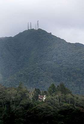
“Moonlight” bungalow is in the foreground. The radio and television station is at the peak of the mountain. Photo credit: Time Tunnel museum
In 1958, the outpost was declared a reserve for deer. Four years later, it became a venue affording protection to animals and birds.[37] [38]
Located on the Main Range (Banjaran Titiwangsa), about 75 percent of the division is over a 1,000 metres (3,300 ft) above sea level. The humidity is high with no marked dry seasons. Its wettest months are from October to November; its “driest” period is from January to February.[39]
.jpg)
The "Camerons" is one of the few places in Malaysia that serves as a habitat for a wide variety of flora and fauna. There are more than 700 species of plants that grow here.[40] The vegetation changes as one ascends the mountain. The ward is known for its tea growing, vegetable farms and flower nurseries.[41] Its woodlands form the prevailing natural ecosystem within and around the prefecture. [42]
Besides its flora, the district is also a shelter for a wide variety of animals, birds, reptiles and insects. Of these, the Sumatran serow, mountain peacock-pheasant and Malayan whistling-thrush are listed in the 2004 IUCN Red List of Threatened Species. [43]
Geographically, the resort is located on the highland “spine” of Peninsular Malaysia. It owes its present standing to its location at a high altitude (generally between 800 metres (2,600 ft) to 1,603 metres (5,259 ft) above sea level). [44]
There are eight mountains at the retreat. They are Mount (Malay: Gunung) Batu Brinchang (2,031 metres (6,663 ft)), Mount Berembun (1,840 metres (6,040 ft)), Mount Irau (2,091 metres (6,860 ft)), Mount Jasar (1,696 metres (5,564 ft)), Mount Mentigi (1,563 metres (5,128 ft)), Mount Perdah (1,576 metres (5,171 ft)) and Mount Siku (1,916 metres (6,286 ft)). [45] Mount Swettenham (1,961 metres (6,434 ft)) is located on its border with Kelantan. At the top of Mount Batu Brinchang is a radio and television station. It was constructed by the British in the early 1950s. Close to it is the mossy forest. The trail to the forest starts from the Sungei Palas Boh Tea Plantation. It takes about 15 minutes to reach the cloud forest by road.

The “Camerons” is unique when compared to the other hill stations in Malaysia — it is drained by three river systems with numerous tributaries (totalling 123). [46] Their high points serve as the water catchment for the Pahang and Perak rivers (Malay: Sungai Pahang and Sungai Perak’').[47]
The environment in the Cameron Highlands needs urgent attention and should be safeguarded. Destruction of forests and hills has become a major problem,” said (Malaysian) Natural Resources and Environment Minister G. Palanivel in a statement.
According to The Star, some 40 hectares of virgin forests in Pos Terisu were fell in less than a month with the bulk of the ravaging spanning at least four valleys and hills. Water quality has deteriorated and the risk of erosions and landslides has risen, said the minister.The Straits Times, 20 May 2013. [48]
Overall, much of the retreat is still forested (estimated at 71 percent). Jungle trails lead visitors to tranquil spots, waterfalls and aboriginal villages. [37] Most of the tracks begin at Tanah Rata. There are more than ten paths to pick and choose from. Depending on its distance, some routes can take as long as five hours to cover.
Apart from its numerous walks, [49] the sanctuary is also known for it aborigines. The aborigines or Orang Asli are basically jungle dwellers. On the surface, their lifestyle has always been made out to be backward. But this has altered over the years. While many have left to take up residence in the nearby towns, there are still some who prefer to treat the woods as their home. [50]
To date, there have been many changes at the resort. During the colonial era, the county was developed to be "a healthy hill station similar to Nuwara Eliya.” [51] Today, it is different.
During the Post-Independence Period (1957–1973), vast tracts of land were cleared for agriculture and infrastructure development. After 1974, more land was cleared for agriculture, housing projects, power plants, logging activities, livestock farming, hotel construction, small-scale industries, human resettlement and road building. [52]
There is no doubt some of the advances have brought on economic benefits. This, however, has come with a price. Over the years, the “development (in this area) has been at the expense of the weather and the environment.” [53]
Transportation
The Cameron Highlands can be accessed by road via Tapah, Simpang Pulai, Gua Musang or Sungai Koyan. [54] Tapah and Simpang Pulai are the two approaches from Perak. Gua Musang and Sungai Koyan are the entryways from Kelantan and Pahang, respectively.
Car
Until the 1990s the only access road to the Cameron Highlands was by route ![]()
![]()
By 2010 a third access route was opened — highway ![]()
There is another route to the hill station — the Pahang State Route (C5). It links Sungai Koyan to Raub which is the gateway to Fraser's Hill.
Public transportation
As with most of western Pahang, the Cameron Highlands is not served by any KTM railway station, the closest being in Kuala Lipis and Tapah. Nevertheless, there are several bus services that connect the Highlands to the other towns in West Malaysia, such as Kuala Lumpur, Ipoh, Penang and Tapah.
See also
- Geography of Malaysia
- Environment of Malaysia
- Landmarks in Cameron Highlands
- Settlements in Cameron Highlands
Places adjacent to Cameron Highlands District | ||||||||||
|---|---|---|---|---|---|---|---|---|---|---|
| ||||||||||
References
Notes
- ↑ http://pdtchighlands.pahang.gov.my/index.php/2012-09-04-08-31-34/pengenalan/senarai-pegawai-daerah
- ↑ ~, ~ MM. "Portal Rasmi PDT Cameron Highlands". pdtchighlands.pahang.gov.my.
- 1 2 "Population Distribution and Basic Demographic Characteristics, 2010" (PDF). Department of Statistics, Malaysia. Archived from the original (PDF) on 22 May 2014. Retrieved 19 April 2012.
- ↑ primuscoreadmin (16 October 2015). "Profil YDP".
- ↑ primuscoreadmin (16 October 2015). "Latar Belakang".
- ↑ "TABURAN PENDUDUK MENGIKUT PBT & MUKIM 2010". Department of Statistics, Malaysia. Retrieved 15 December 2017.
- ↑ Straits Times Weekly Issue, 22 November 1886, Page 1
- ↑ Barr, Pat (1977). TAMING THE JUNGLE. Martin Secker & Warburg Limited. p. 72. ISBN 0-436-03365-8.
- ↑ "Ringkasan Eksekutif RT Cameron Highlands 2030" (PDF) (in Malay).
- ↑ "Geological terrain mapping in Cameron Highlands district, Pahang 2003" (PDF).
- 1 2 3 Moore, Wendy Khadijah (2004). Malaysia: A Pictorial History 1400–2004. Archipelago Press. p. 182. ISBN 981-4068-77-2.
- ↑ Straits Times Weekly Issue, 22 November 1886, Page 1
- ↑ "HISTORY OF CAMERON HIGHLANDS: Need For Continuity Of A Declared Government Policy, The Singapore Free Press and Mercantile Advertiser (1884–1942), Monday, 23 September 1935". p. 3 (Microfilm reel no. NL 3569), National Library, Singapore.
- ↑ Barr, Pat (1977). TAMING THE JUNGLE. Martin Secker & Warburg Limited. p. 72. ISBN 0-436-03365-8.
- ↑ "HISTORY OF CAMERON HIGHLANDS: Need For Continuity Of A Declared Government Policy, The Singapore Free Press and Mercantile Advertiser (1884–1942), Monday, 23 September 1935". p. 3 (Microfilm reel no. NL 3569, National Library, Singapore).
- ↑ De Souza, Edward Roy (2010). SOLVED! The "Mysterious" Disappearance of Jim Thompson, the Legendary Thai Silk King (2nd ed). Word Association Publishers. p. 18. ISBN 978-1-59571-505-0. LCCN 2009944204.
- 1 2 3 "CAMERON'S (?) HIGHLANDS. COMPARISONS WITH OTHER STATIONS., The Singapore Free Press and Mercantile Advertiser (1884–1942), Tuesday, 19 May 1925". p. 11.
- ↑ "Cameron Highlands: Malaysia's enduring 'Little England', CNN Travel, Thursday, 27 June 2013".
- ↑ "CAMERON HIGHLANDS: Government Statement, The Singapore Free Press and Mercantile Advertiser (1884–1942), Friday, 10 June 1927, page 7".
- 1 2 "IN QUEST OF CAMERON'S PLATEAU, The Straits Times, 24 March 1949". p. 8.
- 1 2 3 4 5 "ROAD TO CAMERON'S HIGHLANDS, The Straits Times, Tuesday, 3 March 1931". p. 12.
- ↑ "CAMERON HIGHLANDS: Government Statement, The Singapore Free Press and Mercantile Advertiser (1884–1942), Friday, 10 June 1927". p. 7.
- ↑ "ROAD TO CAMERON'S HIGHLANDS: 70,000 CUBIC YARDS OF GRANITE SHIFTED, The Straits Times, Thursday, 7 June 1928". p. 8.
- ↑ "ROAD TO CAMERON'S HIGHLANDS: $3,000,000 Expended, The Straits Times, Wednesday, 26 November 1930". p. 12.
- ↑ Shennan, Margaret (2000). Out in the Midday Sun: The British in Malaya 1880–1960. John Murray (Publishers) Ltd. p. 128. ISBN 0-7195-5716-X.
- ↑ "Sejarah Cameron Highlands". Pejabat Daerah dan Tanah Cameron Highlands. Retrieved 13 April 2016.
- ↑ "Cameron Highlands Golf, The Straits Times, Friday, 13 September 1935". p. 14.
- ↑ Day, J. David (1990). Malaysia: Gemstone of Southeast Asia. Tropical Press Sdn. Bhd. p. 69. ISBN 967-73-0042-3.
- ↑ De Souza, Edward Roy (2010). SOLVED! The "Mysterious" Disappearance of Jim Thompson, the Legendary Thai Silk King (2nd ed). Word Association Publishers. p. 19. ISBN 978-1-59571-505-0. LCCN 2009944204.
- ↑ "General Climate Information, Malaysian Meteorological Department".
- ↑ "World Weather Information Service — Cameron Highlands". World Meteorological Organization. Retrieved May 6, 2014.
- ↑ "Najib Razak asks MIC chief to stop blaming others for party woes, The Economic Times (online), Monday, 22 June 2015".
- ↑ "MIC president 'loses post' in faction tussle, The Straits Times (online), Tuesday, 23 June 2015".
- ↑ "Ringkasan Eksekutif RT Cameron Highlands 2030" (PDF) (in Malay).
- ↑ "Geological terrain mapping in Cameron Highlands district, Pahang 2003" (PDF).
- ↑ "CAMERON HIGHLANDS ISSUES & CHALLENGES IN SUSTAINABLE DEVELOPMENT 2006" (PDF).
- 1 2 Rodrigo, Jennifer (1996). Malaysia: The Beautiful. New Holland (Publishers) Ltd. p. 19. ISBN 1-85368-744-8.
- ↑ "CAMERON HIGHLANDS ISSUES & CHALLENGES IN SUSTAINABLE DEVELOPMENT 2006" (PDF).
- ↑ "CAMERON HIGHLANDS ISSUES & CHALLENGES IN SUSTAINABLE DEVELOPMENT 2006" (PDF).
- ↑ "CAMERON HIGHLANDS ISSUES & CHALLENGES IN SUSTAINABLE DEVELOPMENT 2006" (PDF).
- ↑ A.Knopf, Alfred (1994). Singapore and Malaysia Archipelago Guides. KNOPF. p. 221. ISBN 981-3018-25-9.
- ↑ "CAMERON HIGHLANDS ISSUES & CHALLENGES IN SUSTAINABLE DEVELOPMENT 2006" (PDF).
- ↑ "CAMERON HIGHLANDS ISSUES & CHALLENGES IN SUSTAINABLE DEVELOPMENT 2006" (PDF).
- ↑ "Geological terrain mapping in Cameron Highlands district, Pahang 2003" (PDF).
- ↑ "CAMERON HIGHLANDS ISSUES & CHALLENGES IN SUSTAINABLE DEVELOPMENT 2006" (PDF).
- ↑ "Integrated Water Resource Management and Pollution Sources in Cameron Highlands, Pahang, Malaysia 2009" (PDF).
- ↑ "CAMERON HIGHLANDS ISSUES & CHALLENGES IN SUSTAINABLE DEVELOPMENT 2006" (PDF).
- ↑ "Cameron Highlands under threat, The Straits Times, Monday, 20 May 2013". p. A9.
- ↑ "A Cool Respite in Highlands Of Malaysia, The New York Times (online), Sunday, 15 July 1990".
- ↑ De Souza, Edward Roy (2010). SOLVED! The "Mysterious" Disappearance of Jim Thompson, the Legendary Thai Silk King (2nd ed). Word Association Publishers. p. 20. ISBN 978-1-59571-505-0. LCCN 2009944204.
- ↑ "Cameron Highlands: Government Statement, The Singapore Free Press and Mercantile Advertiser (1884–1942), Friday, 10 June 1927". p. 7.
- ↑ "CAMERON HIGHLANDS ISSUES & CHALLENGES IN SUSTAINABLE DEVELOPMENT 2006" (PDF).
- ↑ "Muddy teh tarik, anyone?, The New Paper, Saturday, 15 December 2012". p. 20.
- ↑ "Cameron Highlands, Pahang, Malaysia Google map". Google Inc. Retrieved 8 April 2018.
- ↑ Statistik Jalan (Edisi 2013). Kuala Lumpur: Malaysian Public Works Department. 2013. pp. 16–64. ISSN 1985-9619.
- ↑ Statistik Jalan (Edisi 2013). Kuala Lumpur: Malaysian Public Works Department. 2013. pp. 16–64. ISSN 1985-9619.
Books
- De Souza, Edward Roy (2010). SOLVED! The "Mysterious" Disappearance of Jim Thompson, the Legendary Thai Silk King (2nd ed). Word Association Publishers. ISBN 978-1-59571-505-0. LCCN 2009944204.
- Moore, Wendy Khadijah (2004). Malaysia: A Pictorial History 1400–2004. Archipelago Press. ISBN 981-4068-77-2.
- Shennan, Margaret (2000). Out in the Midday Sun: The British in Malaya 1880–1960. John Murray (Publishers) Ltd. ISBN 0-7195-5716-X.
- Rodrigo, Jennifer (1996). Malaysia: The Beautiful. New Holland (Publishers) Ltd. ISBN 1-85368-744-8.
- Day, J. David (1990). Malaysia: Gemstone of Southeast Asia. Tropical Press Sdn. Bhd. ISBN 967-73-0042-3.
- Barr, Pat (1977). TAMING THE JUNGLE. Martin Secker & Warburg Limited. ISBN 0-436-03365-8.
News articles
- "General Climate Information". Malaysian Meteorological Department. Retrieved 2013-01-22.
- "Cameron Highlands in terrible shape due to land clearing and water pollution". The Star. 2012-12-11. Retrieved 2013-01-23.
- "Residents: Land clearing rampant in Cameron Highlands in the last four months". The Star. 2012-10-09. Retrieved 2013-01-23.
- "Stop Rape of Camerons". New Straits Times. 2012-08-28. Retrieved 2013-01-23.
- "Cameron Highlands under threat". New Straits Times. 2012-09-19. Retrieved 2013-02-02.
- "Critical pollution issues plague Cameron Highlands". New Straits Times. 2013-05-18. Retrieved 2013-05-20.
- "Arrest the destruction of our pristine hills". New Straits Times. 2013-06-10. Retrieved 2013-06-21.
- "Cameron hills "rape" just tip of the iceberg". Malaysia Chronicle. 2013-05-21. Retrieved 2013-06-21.
- "Task force formed to salvage Cameron Highlands". The Star. 2013-05-20. Retrieved 2013-05-20.
- "Cameron Highlands environmental blueprint mooted". The Star. 2013-06-08. Retrieved 2013-06-21.
- "Table 3.6: Total population by ethnic group, sex, administrative district and state, Malaysia, 2010 (PDF). Population Distribution and Basic Demographic Characteristics 2010. (p. 67 in PDF)" (PDF). Department of Statistics, Malaysia. Archived from the original (PDF) on 2012-06-17. Retrieved 2013-02-03.
- "Up the highlands, windows down". The Malay Mail. 2013-03-07. Retrieved 2013-03-24.
- "Cameron Highlands: Malaysia's enduring 'Little England'". CNN Travel. 2013-06-27. Retrieved 2013-07-03.
- "80 houses swept away, 3 dead, 1 missing after dam gates opened in Cameron Highlands". The Malaysian Insider. 2013-10-23. Archived from the original on 2013-10-25. Retrieved 2013-12-23.
- "Ringlet dam disaster: Death and destruction on highlands". The Star. 2013-10-24. Retrieved 2013-12-23.
- "Heed lessons from Cameron Highlands tragedy". New Straits Times. 2013-10-28. Retrieved 2013-12-23.
- "Ringlet dam disaster: Palani laments delayed flood reports". The Star. 2013-10-31. Retrieved 2013-12-23.
- "Lake Ringlet is in critical condition". The Star. 2013-11-04. Retrieved 2013-12-23.
- "REACH: Act now or pay deadly price". The Star. 2013-11-05. Retrieved 2013-12-23.
- "Tourist numbers sliding off Cameron Highlands". The Malay Mail. 2013-11-28. Retrieved 2013-12-23.
- "Sharp Decline In Cameron Highlands Tourism". The Star. 2013-11-29. Retrieved 2013-12-23.
- "Pahang govt not carrying out enforcement, says Dawos". New Straits Times. 2014-01-13. Retrieved 2014-01-26.
- "Palanivel: Illegal land clearing must stop". New Straits Times. 2014-01-14. Retrieved 2014-01-26.
- "Environmental experts slam Camerons TOL proposal". The Star. 2014-01-27. Retrieved 2014-01-27.
- "4 dead, 100 homeless but TNB refuses to compensate". Free Malaysia Today. 2014-10-28. Retrieved 2014-11-11.
- "Danger still looms in Bertam Valley". New Straits Times. 2014-11-03. Retrieved 2014-11-11.
- "Cameron Highlands floods: Three dead, five injured". Channel NewsAsia. 2014-11-06. Retrieved 2014-11-11.
- "Reach: Floods and mudslide caused by several factors". The Star. 2014-11-07. Retrieved 2014-11-11.
- "Pahang govt indirectly admits to causing mud flood". Free Malaysia Today. 2014-11-07. Retrieved 2014-11-11.
- "Death certificate for Cameron Highlands — Amar-Singh HSS and Lim Swee Im". The Malaysian Insider. 2014-11-10. Retrieved 2014-11-11.
- "It Will Take RM1 Billion To Save Highlands". Malaysian Digest. 2014-11-14. Retrieved 2014-11-16.
- "Camerons is doomed". New Straits Times. 2014-11-15. Retrieved 2014-11-16.
- "Mud flood slows down flow of tourists to Cameron Highlands". The Rakyat Post. 2014-11-19. Retrieved 2014-12-07.
- "Cameron Highlands — too little, too late". Malaysiakini. 2014-11-20. Retrieved 2014-12-07.
- "Plain ugly greed". New Straits Times. 2014-11-22. Retrieved 2014-12-07.
- "Why reward the destructors of Cameron Highlands?". New Straits Times. 2015-01-30. Retrieved 2015-02-01.
- "DPM upset land clearing in Cameron Highlands still occurs". Borneo Post. 2015-02-04. Retrieved 2015-02-08.
- "REACH claims there are endosulfan contaminated rivers in Cameron Highlands". The Rakyat Post. 2015-02-08. Retrieved 2015-02-08.
- "Don't wait for kids to be born with deformities before acting on Camerons environs issue". The Rakyat Post. 2015-04-02. Retrieved 2015-04-11.
- "Are Malaysians consuming pesticide-laden vege?". The Rakyat Post. 2015-04-09. Retrieved 2015-04-11.
- "Cameron rivers turned into dumps". The Malay Mail. 2015-07-04. Retrieved 2015-08-23.
- "Satellite images can verify deforestation in Cameron Highlands". The Rakyat Post. 2015-10-14. Retrieved 2015-10-27.
- "Banned pesticides still being used in Cameron Highlands". Free Malaysia Today. 2015-12-18. Retrieved 2015-12-20.
- "33 landslide-prone slopes in Cameron Highlands identified". The Sun Daily. 2016-04-12. Retrieved 2016-05-02.
- "RM2.2 billion initiative to save Cameron Highlands". The Sun Daily. 2016-04-19. Retrieved 2016-05-02.
- "Setting up task force is our usual answer". New Straits Times. 2016-07-05. Retrieved 2016-08-06.
- "Slope erosion still causing anxiety in Cameron Highlands". The Malay Mail (online). 2016-08-14. Retrieved 2016-09-10.
- "Three rivers in Cameron Highlands declared 'biologically dead'". TODAY (online). 2017-04-18. Retrieved 2017-05-01.
- "When will Cameron Highlands' traffic woes be solved?". Free Malaysia Today (online). 2017-05-23. Retrieved 2017-06-12.
External links
| Wikimedia Commons has media related to Cameron Highlands. |
![]()
- Cameron Highlands Website
- Official website of Cameron Highlands District Council
- Official website of Regional Environmental Awareness Cameron Highlands (R.E.A.C.H.)
- Rancangan Tempatan Daerah Cameron Highlands 2030 (Penggantian)
Malaysian hill stations | |
|---|---|
| |
Not Available (★Kangar) | |
| |
| |
☆Kuala Lumpur, Labuan and Putrajaya are Federal Territories (Malaysia) and did not have districts. italics for districts created after 2010 census. | |
| Authority control |
|---|