Perak Tengah District
| Perak Tengah District | |
|---|---|
|
| |
| Daerah Perak Tengah | |
| Other transcription(s) | |
| • Chinese | 中霹雳县 |
| • Tamil | பேராக் தெஙஹ் |
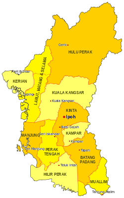 Location of Perak Tengah District in Perak | |
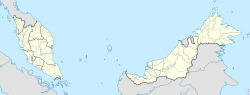 Perak Tengah District Location of Perak Tengah District in Malaysia | |
| Coordinates: 4°15′N 100°55′E / 4.250°N 100.917°ECoordinates: 4°15′N 100°55′E / 4.250°N 100.917°E | |
| Country |
|
| State |
|
| Seat | Seri Iskandar |
| Largest town | Parit |
| Local area government(s) | Perak Tengah District Council |
| Government | |
| • District officer | Ghopran Bin Yeop Hamzah[1] |
| Area[2] | |
| • Total | 1,279.46 km2 (494.00 sq mi) |
| Population (2010)[3] | |
| • Total | 97,530 |
| • Estimate (2015)[4] | 107,600 |
| • Density | 76/km2 (200/sq mi) |
| Time zone | UTC+8 (MST) |
| • Summer (DST) | UTC+8 (Not observed) |
| Postcode | 326xx, 328xx-329xx |
| Calling code | +6-05 |
| Vehicle registration plates | A |
Perak Tengah District Council
The Perak Tengah District is a district in Perak, Malaysia. It is administered by Perak Tengah District Council, which is based at the town of Seri Iskandar; Parit is however the largest settlement in the area.
Administrative divisions
Perak Tengah District is divided into 11 mukims, which are:[5][6]
- Bandar
- Blanja
- Bota
- Jaya Baru
- Kampung Gajah
- Kota Setia
- Lambor (Left & Right)
- Layang-Layang
- Pasir Panjang Hulu
- Pasir Salak
- Pulau Tiga
Demographics
The following is based on Department of Statistics Malaysia 2010 census.[3]
| Ethnic groups in Perat Tengah , 2010 census | ||
|---|---|---|
| Ethnicity | Population | Percentage |
| Bumiputera | 94,664 | 97.0% |
| Chinese | 1,291 | 1.3% |
| Indian | 1,426 | 1.5% |
| Others | 149 | 0.2% |
| Total | 97,530 | 100% |
Federal Parliament and State Assembly Seats
List of Perak Tengah district representatives in the Federal Parliament (Dewan Rakyat)
| Parliament | Seat Name | Member of Parliament | Party |
|---|---|---|---|
| P69 | Parit | Mohd Nizar Zakaria | Barisan Nasional (UMNO) |
| P73 | Pasir Salak | Tajuddin Abdul Rahman | Barisan Nasional (UMNO) |
List of Perak Tengah district representatives in the State Legislative Assembly of Perak
| Parliament | State | Seat Name | State Assemblyman | Party |
|---|---|---|---|---|
| P69 | N38 | Belanja | Khairudin Abu Hanipah | Barisan Nasional (UMNO) |
| P69 | N39 | Bota | Khairul Shahril Mohamed | Barisan Nasional (UMNO) |
| P73 | N49 | Kampong Gajah | Wan Norashikin Wan Nordin | Barisan Nasional (UMNO) |
Transportation
Car
Highways 109 and 5 are the main roads in the district, as well as 72 which goes to Parit and 73 to Batu Gajah.
Public transportation
Rail services are not available in the district; the nearest station is in Batu Gajah.
See also
| Wikimedia Commons has media related to Perak Tengah. |
References
- ↑ "Laman Web Pejabat Daerah Dan Tanah Perak Tengah - Pegawai Daerah". pdtseriiskandar.perak.gov.my.
- ↑ "RTD Perak Tengah 2030" (PDF) (in Malay).
- 1 2 "Population Distribution and Basic Demographic Characteristics, 2010" (PDF). Department of Statistics, Malaysia. Archived from the original (PDF) on 22 May 2014. Retrieved 19 April 2012.
- ↑ "Rancangan Struktur Negeri Perak 2040" (PDF). p. 316.
- ↑ http://apps.water.gov.my/jpskomuniti/dokumen/Laporan%20Profil%20Daerah%20Perak%20Tengah.pdf
- ↑ "Laman Web Pejabat Daerah Dan Tanah Perak Tengah - Statistik Daerah". pdtseriiskandar.perak.gov.my.
External Links
| |
Not Available (★Kangar) | |
| |
| |
☆Kuala Lumpur, Labuan and Putrajaya are Federal Territories (Malaysia) and did not have districts. italics for districts created after 2010 census. | |
This article is issued from
Wikipedia.
The text is licensed under Creative Commons - Attribution - Sharealike.
Additional terms may apply for the media files.