Temerloh
| Temerloh تمرلوه 淡马鲁 தெமர்லோ | ||
|---|---|---|
| Town | ||
 Temerloh Town | ||
| ||
| Country |
| |
| State |
| |
| District | Temerloh District | |
| Establishment | 1889 | |
| Granted municipality status | 15 January 1997[1] | |
| Government | ||
| • Body | Temerloh Municipal Council | |
| • President | Azlan Yaman[2] | |
| Area | ||
| • Total | 2,251 km2 (869 sq mi) | |
| Population (2010)[3] | ||
| • Total | 158,724 | |
| • Density | 71/km2 (180/sq mi) | |
| Postcode | 28xxx | |
| Telephone area code | +60-09 | |
| MPs |
Ismail Mohamed Said (BN) Mohd Anuar Tahir (PH) | |
| Website | mpt.gov.my | |

Temerloh is a municipality in Central Pahang, Malaysia. Located about 130 kilometres (81 mi) from Kuala Lumpur along the Kuantan–Kuala Lumpur trunk road ![]()
An old town with some colonial buildings and shop houses, the town has prospered in recent years as a transport hub and new industrial centre. There have been many new commercial and industrial hub built in Temerloh in recent years. Cutting travel time in half, the newly completed East Coast Expressway ![]()
Temerloh has been proved that it is "The Centre Of Peninsular Malaysia" (Malay: Titik Tengah Semenanjung Malaysia) which actually situated at Kampung Paya Siput, Lanchang.[4]
Etymology
The town is once called "Kuala Semantan" as it situated at Semantan River's confluence. The name Temerloh was derived from the Malay word mereloh meaning sleep. It is said that "Temerloh" came about when a group of Minangkabau settlers, who came to settle at the place, noticed an Orang Asli (aborigine) who slept (mereloh) all through the day without a care in the world. Perhaps as a mark of amazement on such lazy conduct and perhaps for lack of other names to give, or probably just in jest, he then called his settlement there as "Temerloh". Another more plausible theory claims the town's name is derived from the sleep place of orang asli which is called Tempat Mereloh. As the word Tempat Mereloh is hard to pronounce, the Minangkabau settlers shortened it to "Temerloh" as it is easier to pronounce.
Climate
| Climate data for Temerloh | |||||||||||||
|---|---|---|---|---|---|---|---|---|---|---|---|---|---|
| Month | Jan | Feb | Mar | Apr | May | Jun | Jul | Aug | Sep | Oct | Nov | Dec | Year |
| Record high °C (°F) | 32.8 (91) |
35.0 (95) |
35.6 (96.1) |
36.1 (97) |
35.6 (96.1) |
35.0 (95) |
35.0 (95) |
35.0 (95) |
35.0 (95) |
35.0 (95) |
33.9 (93) |
33.3 (91.9) |
36.1 (97) |
| Average high °C (°F) | 29.4 (84.9) |
31.1 (88) |
32.2 (90) |
32.8 (91) |
32.8 (91) |
32.2 (90) |
32.2 (90) |
32.2 (90) |
32.2 (90) |
31.7 (89.1) |
30.6 (87.1) |
30.0 (86) |
31.6 (88.9) |
| Daily mean °C (°F) | 25.6 (78.1) |
26.4 (79.5) |
27.2 (81) |
27.8 (82) |
27.8 (82) |
27.5 (81.5) |
27.2 (81) |
27.2 (81) |
27.2 (81) |
27.2 (81) |
26.7 (80.1) |
26.1 (79) |
27.0 (80.6) |
| Average low °C (°F) | 21.7 (71.1) |
21.7 (71.1) |
22.2 (72) |
22.8 (73) |
22.8 (73) |
22.8 (73) |
22.2 (72) |
22.2 (72) |
22.2 (72) |
22.8 (73) |
22.8 (73) |
22.2 (72) |
22.4 (72.3) |
| Record low °C (°F) | 17.8 (64) |
18.9 (66) |
19.4 (66.9) |
20.6 (69.1) |
20.0 (68) |
20.0 (68) |
20.0 (68) |
19.4 (66.9) |
18.9 (66) |
20.6 (69.1) |
20.6 (69.1) |
18.3 (64.9) |
17.8 (64) |
| Average precipitation mm (inches) | 198.1 (7.799) |
99.1 (3.902) |
152.4 (6) |
193.0 (7.598) |
167.6 (6.598) |
109.2 (4.299) |
86.4 (3.402) |
142.2 (5.598) |
165.1 (6.5) |
236.2 (9.299) |
246.4 (9.701) |
256.6 (10.102) |
2,052 (80.787) |
| Source: Sistema de Clasificación Bioclimática Mundial[5] | |||||||||||||
History
According to Haji Zakaria Hitam, the modern-day Temerloh developed from a small settlement called Kuala Semantan. Kuala Semantan was actually a small old village at the bank of Semantan River. According to the folk story, the name "Semantan" came from the word "Seman Tahan". Osman, or "Seman Tahan" as the villagers called him, is a Bruneian settled at the small river connected to Pahang River. He mastered the martial art of Silat, thus many people came all the way and settled here to learn silat from him. As "Seman Tahan" became popular among the villagers, they named the river "Seman Tahan River". Thus, the town near the river was called "Kuala Seman Tahan" (Kuala in Malay means river confluence). The name "Seman Tahan" gradually becomes "Semantan".
The Temerloh district, on the other hand was established on July 1, 1889, when J. P. Rodger, the first Pahang Resident divided Pahang state into six smaller administration areas (districts): Pekan, Rompin, Kuala Pahang, Kuantan, Temerloh and Hulu Pahang. The capital of Temerloh district then (1 July 1889) was Kuala Semantan. As Kuala Semantan begin to develop rapidly, the name Kuala Semantan was thought unsuitable as the kuala only refers to the river confluence. Hence, Kuala Semantan changed its name to Temerloh. Before the British colonization, Temerloh was governed by several headvillagers (Village level) and Orang Besar (dignitaries) under the Pahang's administration of the "Orang Besar System". The Temerloh's people (then) were mainly Malay and Orang Asli, however there were also small groups of Chinese and Arabs there.
Demographics
The following is based on Department of Statistics Malaysia 2010 census.[3]
| Ethnic groups in Temerloh Municipal Council, 2010
census | ||
|---|---|---|
| Ethnicity | Population | Percentage |
| Bumiputera | 120,154 | 75.7% |
| Chinese | 25,078 | 15.8% |
| Indian | 12,380 | 7.8% |
| Others | 1,111 | 0.7% |
Infrastructure
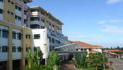
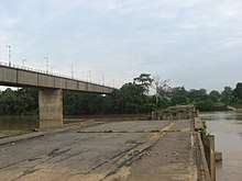
Temerloh is well connected to Kuala Lumpur and Kuantan via the East Coast Expressway and the Karak Expressway. These expressways also link Temerloh to other major towns in Pahang such as Maran, Karak and Bentong. The new state-of-the-art Hospital Sultan Haji Ahmad Shah serves as the main hospital in Central Pahang apart from Hospital Mentakab and Hospital Jengka. To cater to all kinds of sports activities such as athletics and field games, Temerloh Stadium was built and is usually fully utilized during the weekends. There are many shopping places in Temerloh: The Store, Lurah Semantan, Seri Semantan, Bazaar Temerloh, and others. The East Coast Expressway project includes the Sultan Ahmad Shah II Bridge in Temerloh. It crosses the Pahang River, the longest river in west Malaysia.
Hotel Green Park, one of the best hotels in Temerloh, is the tallest building in the town.
Temerloh Mini Stadium is home to match Malaysia Premier League and FAM Cup League Malaysia for the team Pahang FA and Shahzan Muda FC
Tourism
Temerloh town sits at the confluence of the Pahang and Semantan Rivers, which is why it is rich with freshwater fish such as Patin (silver catfish), Jelawat, Baung, Tenggalan, Lampam, Belida, Tilapia and Kerai. As the home of the Patin fish, the Temerloh folks have special dishes that bring out the best taste of the fish. Besides, a visit to the Sunday Bazaar Pekan Sehari is not to be missed. Located along the town's riverside, Pekan Sehari is a place where all kinds of goods and commodities can be found and sold at a reasonable price. In fact this Pekan Sehari is said to be the longest and biggest in the whole of Pahang. The sellers normally come by riverboat early in the morning, and take their place before the customers arrive about 7:00 in the morning. Sunday mornings are busy when boats come and go ferrying passengers and goods to the Pekan Sehari.

Apart from its variety of fish, the town of Temerloh also offers a variety of jungle and wild-life experiences. The Kuala Krau Wildlife Reserve, a virgin forest reserve with untouched flora and fauna, is also where you can find the Kuala Gandah Elephant Conservation Centre and the Seladang Breeding Center. Gunung Senyum Recreational Forest, a paradise for nature and cave lovers is just about 20 kilometres (12 mi) away. Located at Bukit Rengit, Lanchang, the Deerland Park is where you can learn not only about deer, feed and touch them, but also other animals such as ostrich, peacock, tuna deer, nilga deer (India) and wood-duck (Canada). Home to the albino monkey, porcupine, black leopard, civet, the Malayan gharial crocodile and alligators, the town's mini zoo covers over 1.5 hectares (3.7 acres) of land, and is located at Jalan Bahagia, near Kampung Sungai Rabit. There's also a recreational park located right in the middle of Temerloh town, behind the Courthouse, called Taman Bandar (Town Park). Among the facilities provided here are skate-board track, playground, jogging trails and a mini stadium.
Transportation
By road
The old Kuala Lumpur–Kuantan federal highway ![]()
![]()
![]()
![]()
![]()
By rail
The nearest train station to Temerloh is Mentakab train station apart from other minor stations which are situated at Sungai Belengu, Kerdau and Kuala Krau. The train service is provided by the KTMB.
By water
The water transportation among the locals still exists especially for those who live on the banks of the Pahang River. Water transportation is a necessity especially for the farmers to transport their crops as there is no bridge to connect both sides of the river.
Shopping
- Giant Hypermarket Bandar Bukit Angin (proposed)
- Mentakab Starmall (Pacific Hypermarket is one of the anchor tenants)
- Pasaraya Darul Makmur
- Pasaraya Terus Maju
- Pasaraya Tunas Manja
- Savemart (opening soon)
- Super Cowboy
- TF Value-Mart
- Temerloh Mall (TF Value-Mart is anchor tenants)
- The Store
References
- ↑ "Background of Temerloh Municipal Council". Majlis Perbandaran Temerloh.
- ↑ http://www.mpt.gov.my/ms/mpt/pengurusan/profil-ydp
- 1 2 "TABURAN PENDUDUK MENGIKUT PBT & MUKIM 2010". Department of Statistics, Malaysia. Retrieved 15 December 2017.
- ↑ "Kampung Paya Siput diiktiraf titik tengah Semenanjung".
- ↑ "Temerloh (Malaysia)" (PDF). Centro de Investigaciones Fitosociológicas. Retrieved February 1, 2016.
External links
| Wikimedia Commons has media related to Temerloh. |
- "Temerloh.MY" (in Malay). Retrieved October 16, 2011.
- "Temerloh Municipal Council website" (in Malay, English, Chinese, and Hindi). Retrieved October 16, 2011.
- "Temerloh Land and District Office website" (in Malay). Retrieved October 16, 2011.
- "Temerloh Blog" (in Malay). Retrieved October 16, 2011.