Beluran District
| Beluran District Daerah Beluran | |||
|---|---|---|---|
| District | |||
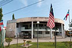 Beluran District Council office. | |||
| |||
 | |||
| Coordinates: 5°52′44″N 117°33′43″E / 5.87889°N 117.56194°ECoordinates: 5°52′44″N 117°33′43″E / 5.87889°N 117.56194°E | |||
| Country |
| ||
| State |
| ||
| Division | Sandakan | ||
| Capital | Beluran | ||
| Government | |||
| • District Officer | Yusof Haji Osman | ||
| Area | |||
| • Total | 8,345 km2 (3,222 sq mi) | ||
| Population (2010) | |||
| • Total | 104,484 | ||
| Website |
ww2 ww2 | ||


The Beluran District (Malay: Daerah Beluran) is an administrative district in the Malaysian state of Sabah, part of the Sandakan Division which includes the districts of Beluran, Kinabatangan, Sandakan, Telupid and Tongod. The capital of the district is in Beluran Town.
Etymology
The name Beluran was taken after the name of a hill in the district. In the languages of Labuk Dusun, Sungai and Tidong, it is called as "Buludan". Several changes occurred during the British administration as a result of misnomeration by British colonial officials who does not speak fluent local languages causing the name "Buludan" became "Beluran" which later maintained until this day.[1]
History
The district is formerly known as the Labuk-Sugut District and has existed since the North Borneo Chartered Company administration. It is one of the earliest districts in North Borneo. The Beluran District Administration Office was established as early as 1916 but all records and data of the district were destroyed in the Second World War. According to some old sources, B.S Willie was appointed as Beluran District Officer in 1945 with Klagan became the first administrative district of Labuk-Sugut District, but as the area was often flooded, the British authorities transferred the administrative centre to the foothills of present-day Beluran.[1]
Demographics
According to the latest census in 2010, the population of the district is estimated to be around 104,484 inhabitants.[2] The population consists of a mixture of various indigenous ethnic groups, such as Kadazan-Dusun, Tidong, Bajau, Suluk, Orang Sungai as well as a significant presence of Chinese.[1] As in other districts of Sabah, there are a significant number of illegal immigrants from the nearby southern Philippines, mainly from the Sulu Archipelago and Mindanao of whom are not included in the population statistics.
Gallery
 Beluran District Mosque.
 St. Peter Catholic Church.
 Beluran virgin jungle.
See also
References
- 1 2 3 "Latar Belakang Daerah Beluran" (in Malay). Beluran District Council. Archived from the original on 7 November 2017. Retrieved 7 November 2017.
- ↑ "Population by ethnic group, Local Authority area and state, Malaysia" (PDF). Department of Statistics, Malaysia. 2010. Archived from the original (PDF) on 27 February 2012. Retrieved 5 November 2017.
Further reading
- Treacher, W. H (1891). "British Borneo: sketches of Brunai, Sarawak, Labuan, and North Borneo". University of California Libraries. Singapore, Govt. print. dept. p. 190.
- Rutter, Owen (1922). "British North Borneo - An Account of its History, Resources and Native Tribes". Cornell University Libraries. Constable & Company Ltd, London. p. 157.
- Tregonning, K. G. (1965). A History Of Modern Sabah (North Borneo 1881–1963). University of Malaya Press.
External links
![]()
- (in Malay) Beluran District Council
- (in Malay) Beluran District Office
| |
Not Available (★Kangar) | |
| |
| |
☆Kuala Lumpur, Labuan and Putrajaya are Federal Territories (Malaysia) and did not have districts. italics for districts created after 2010 census. | |