Lojing
| Lojing Autonomous Sub-District | |
|---|---|
|
| |
| Jajahan Kecil Lojing | |
| Other transcription(s) | |
| • Jawi | لوجيڠ |
| • Chinese | 罗京副县 |
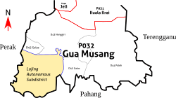 Map of Lojing relative to Gua Musang in southern Kelantan. The territory of Jajahan Kecil Lojing overlaps with the electoral boundaries of the state assembly constituencies of Galas and Nenggiri. | |
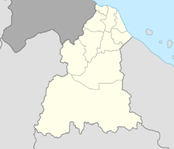 Lojing Autonomous Sub-District Location of Lojing in Kelantan  Lojing Autonomous Sub-District Lojing Autonomous Sub-District (Malaysia) | |
| Coordinates: 4°38′N 101°28′E / 4.633°N 101.467°ECoordinates: 4°38′N 101°28′E / 4.633°N 101.467°E | |
| Country |
|
| State |
|
| District |
|
| Area[1] | |
| • Total | 1,817 km2 (702 sq mi) |
| Population (2010)[1] | |
| • Total | 6,686 |
| • Density | 3.7/km2 (9.5/sq mi) |
| Time zone | UTC+8 (MST) |
| • Summer (DST) | UTC+8 (Not observed) |
| Postcode | 18xxx |
| Calling code | +6-09 |
| Vehicle registration plates | D |
Lojing or Lojing Highlands (Jawi: لوجيڠ, Chinese: 罗京) is a hill village in the Gua Musang constituency of Kelantan, Malaysia. It is located right next to Cameron Highlands in Pahang, along the Second East-West Highway ![]()
In 2010 Lojing was made an autonomous sub-district (Jajahan Kecil Lojing). Several state and federal agencies will open their branches there following the arrangement; municipal works remain under the responsibility of Gua Musang. It is divided into three communes: Betis, Hau and Sigar.[1]
The Lojing Highlands is rich in flora and fauna and is famed for its biodiversity. Its well preserved pristine hills and jungles are popular eco tourist attraction. There are many species of high quality tropical hardwood such as teak, mahogani, chengal and meranti located in the jungles of the Lojing Highlands. Most of the people that live in the Lojing area belong to the indigenous Orang Asli tribes.[1]
References
- 1 2 3 4 "Jajahan Kecil Lojing" (PDF) (in Malay).
Capital: Kota Bharu | |||||||
| Topics |
| ||||||
| Society |
| ||||||
| Administrative divisions |
| ||||||
| |||||||