Tumpat District
| Tumpat District | ||
|---|---|---|
|
| ||
| Jajahan Tumpat | ||
| Other transcription(s) | ||
| • Jawi | تومڤت | |
| ||
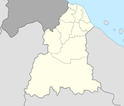 Tumpat District Location of Tumpat District in Kelantan  Tumpat District Tumpat District (Malaysia) | ||
| Coordinates: 6°10′N 102°10′E / 6.167°N 102.167°ECoordinates: 6°10′N 102°10′E / 6.167°N 102.167°E | ||
| Country |
| |
| State |
| |
| Seat | Tumpat | |
| Local area government(s) | Tumpat District Council | |
| Government | ||
| • District officer | Rosnazli Amin[1] | |
| Area[2] | ||
| • Total | 169.5 km2 (65.4 sq mi) | |
| Population (2010)[3] | ||
| • Total | 152,168 | |
| • Density | 900/km2 (2,300/sq mi) | |
| Time zone | UTC+8 (MST) | |
| • Summer (DST) | UTC+8 (Not observed) | |
| Postcode | 16xxx | |
| Calling code | +6-09 | |
| Vehicle registration plates | D | |

Tumpat (Kelantanese: Ttupak) is a district (jajahan) in Kelantan, Malaysia. Tumpat is situated at the end of the East Coast Line train line operated by Keretapi Tanah Melayu (Malayan Railways) which links Kelantan to the western part of Peninsular Malaysia. This strategic location makes it the transportation hub of Kelantan. Tumpat town is approximately 15 km from the state capital, Kota Bharu.
Geography
Tumpat is the northernmost constituency in Kelantan, bordering Thailand across the Golok River to the west, Kota Bharu across the Kelantan River to the east, and Pasir Mas to the south.
Demographics
Tumpat has a population about 152,168 (2010), with the majority being the Malays with significant Siamese, Indian and Chinese population.[3]
Ranking Population of Jajahan Tumpat:
| Rank | Daerah/Mukim | Population 2000 |
|---|---|---|
| 1 | Wakaf Bharu | 29,902 |
| 2 | Pengkalan Kubur | 20,642 |
| 3 | Tumpat | 19,896 |
| 4 | Sungai Pinang | 16,622 |
| 5 | Terbak | 16,096 |
| 6 | Kebakat | 14,663 |
| 7 | Jalan Besar | 12,595 |
| 8 | Palekbang | |
| 9 | Kelaboran | |
| 10 | Kampung Laut | |
| 11 | Kok Keli | |
| 12 | Berangan | |
| 13 | Bunohan | |
| 14 | Geting | |
| 15 | Morak | |
| 16 | Pasir Pekan | |
Politics
Tumpat is currently represented in the Dewan Rakyat of the Malaysian Parliament by Dato' Kamarudin Jaffar of PKR, having crossed over from PAS in 2015.
On the state level, Tumpat supplies 4 seats to the Kelantan State Legislative Assembly:
- Pengkalan Kubur;
- Kelaboran;
- Wakaf Bharu; and
- Pasir Pekan.
Save for the border town of Pengkalan Kubur, which was held by BN, the other three seats are currently in PAS's hold.
Tourist attractions
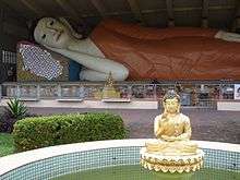
- Wat Machimmaram
- Wat Phothivihan
Transportation
Public transport
Tumpat is perhaps famous for being the northern terminal of the KTM East Coast Line, which began in Gemas in Negeri Sembilan. Bus options to Kota Bharu and Kuala Terengganu are available.
Car
The main federal highway serving Tumpat constituency is highway ![]()
![]()
![]()
Notable people
References
- ↑ User, Super. "District Officers Of Tumpat". www.ptjt.kelantan.gov.my.
- ↑ "Latar Belakang Tumpat". 26 June 2016.
- 1 2 "Population Distribution and Basic Demographic Characteristics, 2010" (PDF). Department of Statistics, Malaysia. Archived from the original (PDF) on 22 May 2014. Retrieved 19 April 2012.
| Wikimedia Commons has media related to Tumpat. |
Capital: Kota Bharu | |||||||
| Topics |
| ||||||
| Society |
| ||||||
| Administrative divisions |
| ||||||
| |||||||