Bentong
| Bentong ﺑﻨﺘﻮڠ 文冬 | ||
|---|---|---|
| Municipality of Malaysia | ||
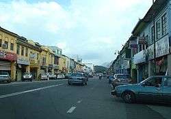 Loke Yew Street in Bentong town | ||
| ||
| Coordinates: 3°31′N 101°55′E / 3.517°N 101.917°ECoordinates: 3°31′N 101°55′E / 3.517°N 101.917°E | ||
| Country |
| |
| State |
| |
| District | Bentong District | |
| Granted municipality status | 16 July 2005[1] | |
| Government | ||
| • Body | Bentong Municipal Council | |
| • Yang Dipertua | Dato' Mohammad Shahid Bin Ismail | |
| Area | ||
| • Total | 867.69[2] km2 (Formatting error: invalid input when rounding sq mi) | |
| Population (2010) | ||
| • Total | 114,397 | |
| Postcode | 28xxx | |
| Telephone area code | +6-09 | |
| Vehicle registration | C | |
| MP | Wong Tack (DAP) | |
| Website |
www | |

Bentong (Jawi: ﺑﻨﺘﻮڠ) is a municipality located in western Pahang, Malaysia. The original main street going into Bentong town has been modified to a dual carriageway and now Bentong Town has been declared as the first “Fresh Air Lung Washing” destination in the country.[3]
History
According to an old story, Bentong was previously known as Carlo Sas. It was changed from Papi to Bentong before World War I. In earlier times, the center of Bentong was around the market area, at the meeting point of the Chongki rivers Repas and Perting.
The most important transportation way at that time was the rivers by using perahu (small boats). The jetty was situated in front of current rest house (near current Bentong Police Station).
Bentong became a focal point when tin ore was discovered in the two main rivers, Repas and Perting. Tin developers constructed ‘ban’ to extract more ore, hence more profits. The practice became a talking matter to the people outside Bentong, who referred to it as the story of ‘ban untung’ (the Profitable Ban). ‘Ban Untung’ became more well-known than Kapong that later people began to call it Ban Untung. From the name ‘Ban Untung’ was what the name for the district of Bentong derived from.
From other story, according to Pak Zek (Budayawan Dato’ Haji Zakaria bin Hitam), the name Bentong originated from ‘Bapong’ (meaning float). Bentong was once used as a fort by Dato’ Bahaman. The British army sent over the Gurkhas mercenary to defeat Dato’ Bahaman to take over the area. However, a number of the Gurkhas were killed after they were ambushed by Dato’ Bahaman’s men. Their bodies were thrown into the river and floated in the water. Following the incident, the site was known as Bapong, and later known as Bentong. The exact date of the name change was on 31 August 1957.
Weather
Bentong average temperature is on 26.8 °C (80.2 °F) while 2,419 millimetres (95.2 in) rainfall every month.[4]
| Climate data for Bentong | |||||||||||||
|---|---|---|---|---|---|---|---|---|---|---|---|---|---|
| Month | Jan | Feb | Mar | Apr | May | Jun | Jul | Aug | Sep | Oct | Nov | Dec | Year |
| Daily mean °C (°F) | 26 (79) |
26.6 (79.9) |
27 (81) |
27.5 (81.5) |
27.4 (81.3) |
27.1 (80.8) |
26.7 (80.1) |
27.1 (80.8) |
26.8 (80.2) |
26.8 (80.2) |
26.7 (80.1) |
26.4 (79.5) |
26.8 (80.4) |
| Average precipitation mm (inches) | 185 (7.28) |
149 (5.87) |
179 (7.05) |
233 (9.17) |
226 (8.9) |
133 (5.24) |
133 (5.24) |
142 (5.59) |
188 (7.4) |
278 (10.94) |
315 (12.4) |
258 (10.16) |
2,419 (95.24) |
| Source: Climate-Data.org (altitude: 77m)[4] | |||||||||||||
Tourism Attraction
- Genting Highlands
- Berjaya Hill Bukit Tinggi Resort
- Bentong Gallery
- Bentong Kwong Fook Temple
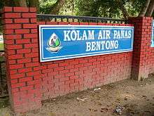
- Bentong Hot Spring
- Chamang Waterfall
- Lentang Forest Reserves
References
- ↑ http://www.mpbentong.gov.my/en/mpb/profile/background/page/0/1 |title=Background: Page 2 of 2 |publisher=Majlis Perbandaran Bentong
- ↑ primuscoreadmin (5 January 2016). "Latar Belakang".
- ↑ https://www.themalaysianinsight.com/s/12573/
- 1 2 "Climate: Bentong - Climate graph, Temperature graph, Climate table". Climate-Data.org. Retrieved 2017-08-28.
External links
| Wikimedia Commons has media related to Bentong. |
| Authority control |
|---|