Tawau District
| Tawau District Daerah Tawau | ||
|---|---|---|
| District | ||
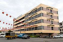 Tawau Municipal Council office. | ||
| ||
 | ||
| Coordinates: 4°14′33.4″N 117°53′33.16″E / 4.242611°N 117.8925444°ECoordinates: 4°14′33.4″N 117°53′33.16″E / 4.242611°N 117.8925444°E | ||
| Country |
| |
| State |
| |
| Division | Tawau | |
| Capital | Tawau | |
| Government | ||
| • District Officer | Alijus Sipil | |
| Area | ||
| • Total | 6,125 km2 (2,365 sq mi) | |
| Population (2010) | ||
| • Total | 397,673 | |
| Website |
mpt | |

The Tawau District (Malay: Daerah Tawau) is an administrative district in the Malaysian state of Sabah, part of the Tawau Division which includes the districts of Kunak, Lahad Datu, Semporna and Tawau. The capital of the district is in Tawau Town.
History
The administration of Tawau changed several times in the course of its history. From 1890, the administration managed by the North Borneo Chartered Company, which put this task alternately in the hands of various residents, district officers or candidates for the office of the district officers. During the Japanese occupation, the administration was carried out by Japanese military personnel. The pre-war administration system was continued after the end of World War II. The post-war administration of the city was from 1948 to 1955 by the provisions of the Reconstruction and Development Plan, drafted by the Development Officer of the Government, E. W. Ellison who closely tied to the British colonial government.[1] Only in 1955 did the city regain full control over its finances and administration of its public office with the founding of the Tawau Town Board. Even after the formation of Malaysia in 1963, the modern state of Sabah continued to use residents and district officers until 1981.[2] On 1 January 1982, the Tawau Town Board and the Tawau Rural District Council was merged to became the Tawau Municipal Council.[3] In March 1983, Tawau was administratively divided into four areas: urban area (5,918 hectares), suburbs (4,783 hectares), surrounding countryside (591,384 hectares) and sea area (26,592 hectares).[4]
Demographics
Tawau district is the second largest of Sabah's 25 districts, with 397,673 inhabitants after Kota Kinabalu.[5]
Gallery

 St. Patrick Anglican Church.
 Tawau Basel Church.
 Holy Trinity Catholic Church.
 Holy Grace Methodist Church.
 Pu Zhao Temple.
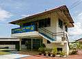 Gurdwara Sahib Tawau.
 Thirumurugan Temple.
 Tukok Hill Estate.
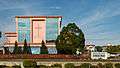
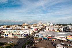 Tawau town centre.
See also
References
- ↑ Goodlet 2010, pp. 133.
- ↑ Goodlet 2010, pp. 3.
- ↑ "State of Sabah [Enactment No. 37]" (PDF). Sabah State Attorney's General Chambers. 1981. Archived from the original (PDF) on 8 November 2017. Retrieved 8 November 2017.
- ↑ Goodlet 2010, pp. 249.
- ↑ "Population by ethnic group, Local Authority area and state, Malaysia" (PDF). Department of Statistics, Malaysia. 2010. Archived from the original (PDF) on 27 February 2012. Retrieved 5 November 2017.
Literature
- Goodlet, Ken (2010). Tawau: The Making of a Tropical Community. Opus Publications. ISBN 978-983-3987-38-2.
Further reading
- Treacher, W. H (1891). "British Borneo: sketches of Brunai, Sarawak, Labuan, and North Borneo". University of California Libraries. Singapore, Govt. print. dept. p. 190.
- Rutter, Owen (1922). "British North Borneo - An Account of its History, Resources and Native Tribes". Cornell University Libraries. Constable & Company Ltd, London. p. 157.
- Tregonning, K. G. (1965). A History Of Modern Sabah (North Borneo 1881–1963). University of Malaya Press.
External links
![]()
- (in Malay) Tawau Municipal Council
| |
Not Available (★Kangar) | |
| |
| |
☆Kuala Lumpur, Labuan and Putrajaya are Federal Territories (Malaysia) and did not have districts. italics for districts created after 2010 census. | |