Beverley Road (BMT Brighton Line)
Beverley Road | |||||||
|---|---|---|---|---|---|---|---|
|
| |||||||
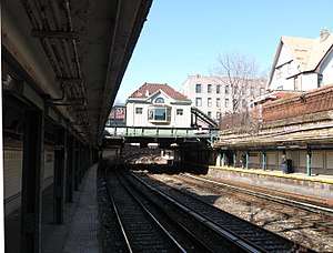 Looking north towards the station house from the Coney Island-bound platform | |||||||
| Station statistics | |||||||
| Address |
Beverly Road & East 16th Street Brooklyn, NY 11226 | ||||||
| Borough | Brooklyn | ||||||
| Locale | Ditmas Park, Flatbush | ||||||
| Coordinates | 40°38′41″N 73°57′52″W / 40.644625°N 73.964472°WCoordinates: 40°38′41″N 73°57′52″W / 40.644625°N 73.964472°W | ||||||
| Division | B (BMT) | ||||||
| Line | BMT Brighton Line | ||||||
| Services |
Q | ||||||
| Structure | Open-cut | ||||||
| Platforms | 2 side platforms | ||||||
| Tracks | 4 | ||||||
| Other information | |||||||
| Opened | original station: c. 1900 | ||||||
| Rebuilt | current station: 1907 | ||||||
| Station code | 045[1] | ||||||
| Traffic | |||||||
| Passengers (2017) |
1,038,252[2] | ||||||
| Rank | 354 out of 425 | ||||||
| Station succession | |||||||
| Next north |
Church Avenue: Q | ||||||
| Next south |
Cortelyou Road: Q | ||||||
| |||||||
| |||||||
| |||||||
|
| |||||||
|
Beverley Road Subway Station (BRT pre-Dual System) | |||||||
| MPS | New York City Subway System MPS | ||||||
| NRHP reference # | 04001024[3] | ||||||
| Added to NRHP | July 17, 2004 | ||||||


Beverley Road is a local station on the BMT Brighton Line of the New York City Subway. It is located over a private right-of-way at Beverly Road between Marlborough Road/East 15th Street and East 16th Street in the neighborhood of Flatbush, Brooklyn. It is served by the Q train at all times.[4]
History
The original station at this location was opened around 1900 as a two-track street-level side platform station running south from a grade crossing at Beverley Road. The station was established to serve the then-new upscale planned community of Prospect Park South. The current station house and below-grade platforms were completed at the end of 1907, and have been on the National Register of Historic Places since 2004.[5]
During the 1964–1965 fiscal year, the platforms at Beverley Road, along with those at six other stations on the Brighton Line, were lengthened to 615 feet to accommodate a ten-car train of 60-foot IND cars, or a nine-car train of 67-foot BMT cars.[6]
Station layout
| G | Street level | Station building, entrance/exit, station agent, MetroCard vending machines |
| P Platform level |
Side platform, doors will open on the right | |
| Northbound local | ← | |
| Northbound express | ← | |
| Southbound express | | |
| Southbound local | | |
| Side platform, doors will open on the right | ||
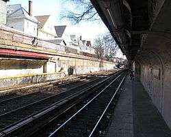
This open-cut station has four tracks and two side platforms, typical for a New York City Subway local station.[7]
This station is spelled with three "e"s, unlike its Nostrand Avenue IRT counterpart, which is spelled with two, reflecting the original spelling of the street's name. The 1907 station-house was the focus of an early 1990s in-house renovation. Sitting on the open-cut portion of the Brighton Line, another gentle curve to the right is at the far north end along with clearly visible platform extensions, allowing passengers to watch trains between Church Avenue and Cortelyou Road.
Exit
The station's sole entrance is through a station house at Beverly Road between Marlborough Road and East 16th Streets.[8] The station-house features artwork called Garden Stops by Patsy Norvell, which has etched images of leaves on the glass windows inside fare control facing the south. The artwork can be seen from both inside the mezzanine and while standing on either platform to the south; this artwork is also visible at the neighboring Cortelyou Road station.[9] Colors at this station are green and beige.
References
- ↑ "Station Developers' Information". Metropolitan Transportation Authority. Retrieved June 13, 2017.
- ↑ "Facts and Figures: Annual Subway Ridership 2012–2017". Metropolitan Transportation Authority. July 12, 2018. Retrieved July 12, 2018.
- ↑ "NPS Focus". National Register of Historic Places. National Park Service. Retrieved December 12, 2011.
- ↑ "Q Subway Timetable, Effective June 24, 2018" (PDF). Metropolitan Transportation Authority. Retrieved June 24, 2018.
- ↑ Kings County Listings on the National Register of Historic Places (Structure #04001024)
- ↑ Annual Report 1964–1965. New York City Transit Authority. 1965.
- ↑ Dougherty, Peter (2006) [2002]. Tracks of the New York City Subway 2006 (3rd ed.). Dougherty. OCLC 49777633 – via Google Books.
- ↑ "MTA Neighborhood Maps: Flatbush" (PDF). mta.info. Metropolitan Transportation Authority. 2015. Retrieved 2 August 2015.
- ↑ http://culturenow.org/entry&permalink=04717&seo=Garden-Stops_Patsy-Norvell-and-MTA-Arts-For-Transit
External links
| Wikimedia Commons has media related to Beverley Road (BMT Brighton Line). |
- nycsubway.org – BMT Brighton Line: Beverley Road
- Station Reporter — Q train
- The Subway Nut — Beverley Road Pictures
- MTA's Arts For Transit — Beverley Road (BMT Brighton Line)
- Beverley Road entrance from Google Maps Street View
- Platforms from Google Maps Street View
Broadway Express/ Brighton Local |
|
|---|---|
| |
| Brighton Line |
|
|---|---|
| |
| Topics |   | |
|---|---|---|
| Lists by county |
| |
| Lists by city | ||
| Other lists | ||
| ||