Cortelyou Road (BMT Brighton Line)
Cortelyou Road | |||||||
|---|---|---|---|---|---|---|---|
|
| |||||||
 | |||||||
| Station statistics | |||||||
| Address |
Cortelyou Road & East 16th Street Brooklyn, NY 11226 | ||||||
| Borough | Brooklyn | ||||||
| Locale | Ditmas Park, Flatbush | ||||||
| Coordinates | 40°38′30″N 73°57′51″W / 40.641597°N 73.9643°WCoordinates: 40°38′30″N 73°57′51″W / 40.641597°N 73.9643°W | ||||||
| Division | B (BMT) | ||||||
| Line | BMT Brighton Line | ||||||
| Services |
Q | ||||||
| Transit connections |
| ||||||
| Structure | Open-cut | ||||||
| Platforms | 2 side platforms | ||||||
| Tracks | 4 | ||||||
| Other information | |||||||
| Opened | original station: c. 1900 | ||||||
| Rebuilt | current station: 1907 | ||||||
| Station code | 046[1] | ||||||
| Former/other names | Avenue C | ||||||
| Traffic | |||||||
| Passengers (2017) |
2,028,859[2] | ||||||
| Rank | 242 out of 425 | ||||||
| Station succession | |||||||
| Next north |
Beverley Road: Q | ||||||
| Next south |
Newkirk Plaza: Q | ||||||
| |||||||
| |||||||
| |||||||


Cortelyou Road is a local station on the BMT Brighton Line of the New York City Subway, located at Cortelyou Road between Marlborough Road (East 15th Street) and East 16th Street in the neighborhood of Flatbush, Brooklyn. It is served by the Q train at all times.[3]
History
The station, and the road it is named after, are named for 17th-century tutor and surveyor Jacques Cortelyou, who had a hand in the establishment of New Utrecht.[4]
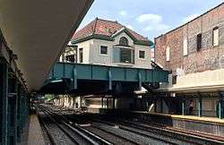
The original station at this location was opened around 1900 as a two-track street-level side platform station running south from a grade crossing at Avenue C. The station was established to serve the commercial area of Avenue C, a major thoroughfare which boasted the only east-west streetcar line between Church Avenue in Flatbush and Sheepshead Bay. The current station house and below-grade platforms were completed at the end of 1907. At the same time, the station was renamed from Avenue C[5] to Cortelyou Road.
During the 1964–1965 fiscal year, the platforms at Cortelyou Road, along with those at six other stations on the Brighton Line, were lengthened to 615 feet to accommodate a ten-car train of 60-foot IND cars, or a nine-car train of 67-foot BMT cars.[6]
Rehabilitation work on the platforms was performed in 1994.
From July to October 28, 2013, the northbound platform was closed for rehabilitation.[7][8] From February 21 to June 13, 2014, the southbound platform was closed as part of a $3.2 million component repair project, which included work at the Beverley Road and Parkside Avenue stations.[9][10]
Station layout
| G | Street level | Station building, entrance/exit, station agent, MetroCard vending machines |
| P Platform level |
Side platform, doors will open on the right | |
| Northbound local | ← | |
| Northbound express | ← | |
| Southbound express | | |
| Southbound local | | |
| Side platform, doors will open on the right | ||
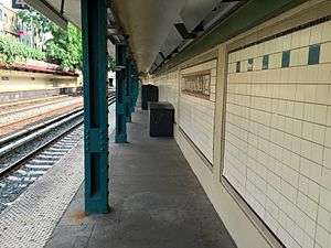
This open-cut station has four tracks and two side platforms, typical for a New York City Subway local station.[11]
The station physically resembles the nearby Beverley Road station as the layout and station house are both the same. There are some differences, however. This station has blue columns while Beverley Road has green, there is a signal house for New York City Transit use on the north end that replicates the station house across the street, and the location of the station house in relation to the platforms, is slightly to the north compared to the same location at Beverley Road. Colors at this station are green and beige.
Exit
The station's sole entrance is through a station house at Cortelyou Road between East 15th and East 16th Streets.[12] The station house features artwork called Garden Stops by Patsy Norvell, which has etched images of leaves on the glass windows inside fare control facing the south. The artwork can be seen from both inside the mezzanine and while standing on either platform to the south; this artwork is also visible at the neighboring Beverley Road station.[13]
References
- ↑ "Station Developers' Information". Metropolitan Transportation Authority. Retrieved June 13, 2017.
- ↑ "Facts and Figures: Annual Subway Ridership 2012–2017". Metropolitan Transportation Authority. July 12, 2018. Retrieved July 12, 2018.
- ↑ "Q Subway Timetable, Effective June 24, 2018" (PDF). Metropolitan Transportation Authority. Retrieved June 24, 2018.
- ↑ Wilson, Claire (June 5, 2005). "A Commercial Strip Gaining in Charm". The New York Times. Retrieved 11 August 2016.
- ↑ District, New York (State) Public Service Commission First (1921-01-01). Annual Report for the Year Ended ... The Commission.
- ↑ Annual Report 1964–1965. New York City Transit Authority. 1965.
- ↑ "MTA | news | Manhattan-bound Brighton Q Line Platforms at Three Stations to Re-open After 4-Month Closure". www.mta.info. Retrieved 2016-10-09.
- ↑ "Cortelyou Road station rehab will kill our business, merchants say". The Brooklyn Paper. Retrieved 2016-10-09.
- ↑ "MTA | Press Release | NYC Transit | Brooklyn-bound Cortelyou Rd Q Line Platform Re-opens". www.mta.info. Retrieved 2016-10-09.
- ↑ "Brighton Line Subway Station Rehabilitation | Brooklyn Community Board 14 | Brooklyn Community Board 14". www.cb14brooklyn.com. Retrieved 2016-10-09.
- ↑ Dougherty, Peter (2006) [2002]. Tracks of the New York City Subway 2006 (3rd ed.). Dougherty. OCLC 49777633 – via Google Books.
- ↑ "MTA Neighborhood Maps: Flatbush" (PDF). mta.info. Metropolitan Transportation Authority. 2015. Retrieved 2 August 2015.
- ↑ http://culturenow.org/entry&permalink=04717&seo=Garden-Stops_Patsy-Norvell-and-MTA-Arts-For-Transit
External links
| Wikimedia Commons has media related to Cortelyou Road (BMT Brighton Line). |
- nycsubway.org – BMT Brighton Line: Cortelyou Road
- Station Reporter — Q Train
- MTA's Arts For Transit — Cortelyou Road (BMT Brighton Line)
- The Subway Nut — Cortelyou Road Pictures
- Cortelyou Road entrance from Google Maps Street View
- Platforms from Google Maps Street View
Broadway Express/ Brighton Local |
|
|---|---|
| |
| Brighton Line |
|
|---|---|
| |