Bengkulu
| Bengkulu | |||
|---|---|---|---|
| Province | |||
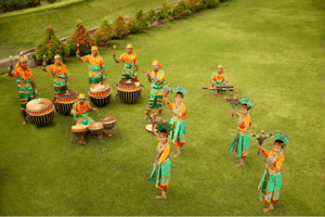   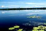 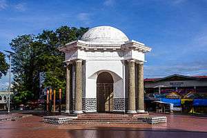 From top, left to right : Lake Dendam Tak Sudah, Bengkulu Traditional Dance, Grand Mosque of Curup, Rafflesia arnoldi, Soekarno's house while in exile in Bengkulu, Lake Dusun Besar, Thomas Parr Monument | |||
| |||
|
Nickname(s): Bumi Rafflesia Land of Rafflesia | |||
|
Motto(s): Sekundang setungguan seio sekato (Malay) (Many hands make light work.) | |||
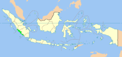 Location of Bengkulu (marked in light green) in Indonesia | |||
 | |||
| Country |
| ||
| Established | 18 November 1968 | ||
| Capital and Largest City |
| ||
| Government | |||
| • Body | Bengkulu Regional Government | ||
| • Governor | Dr. H. Rohidin Mersyah, M.M | ||
| Area | |||
| • Total | 19,919.33 km2 (7,690.90 sq mi) | ||
| Area rank | 24th | ||
| Population (2017[1]) | |||
| • Total | 1,934,300 | ||
| • Rank | 26th | ||
| • Density | 97/km2 (250/sq mi) | ||
| Demonym(s) |
Bengkulunese Warga Bengkulu (id) | ||
| Demographics | |||
| • Ethnic groups | Rejang (60,4%), Javanese (22,3%), Serawai (17,9%), Lembak (4,9%), Pasemah (4,4%), Minangkabau (4,3%), Malay (3,6%), Sundanese (3%), Batak (2%)[2] | ||
| • Religion | Islam 95,27%, Christianity 3,59%, Hindu 0,73%, Buddhism 0,41% | ||
| • Languages | Indonesian (official language), Rejangese, Javanese language, Serawai, Lembak language, etc. | ||
| Time zone | UTC+7 (Indonesia Western Time) | ||
| Area code(s) | 0732 (Kepahiang, Curup or Rejang Lebong), 0736 (Bengkulu, Central Bengkulu, Seluma), 0737 (Muko-Muko, North Bengkulu), 0738 (Lebong), 0739 (Kaur, South Bengkulu) | ||
| Vehicle registration | BD | ||
| HDI |
| ||
| HDI rank | 11th (2013)[4] | ||
| Largest city by area | Bengkulu - 144.52 square kilometres (55.80 sq mi) | ||
| Largest city by population | Bengkulu - (308,756 - 2010) | ||
| Largest regency by area | North Bengkulu Regency - 5,548.54 square kilometres (2,142.30 sq mi) | ||
| Largest regency by population | North Bengkulu Regency - (256,358 - 2010) | ||
| Website | Government official site | ||


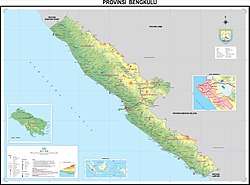
Bengkulu, historically known as Bencoolen or British Bencoolen,[5][6] is one of the Provinces of Indonesia and is located in the southwest coast of Sumatra. It was formed on 18 November 1968 by separating out the former Bengkulu Residency area from South Sumatra (Sumatra Selatan) province under Law No. 9 of 1967 and was realized by Government Regulation No. 20 of 1968. Spread over 19,813 km2, it is bordered by the provinces of West Sumatra (Sumatra Barat) to the north, Jambi to the northeast, Lampung to the southeast, South Sumatra (Sumatra Selatan) to the east, and the India Ocean to the northwest, south, southwest, and west.
Bengkulu is the 25th largest province by area; it is divided into nine regencies and the separate city of Bengkulu, the capital and largest city. Bengkulu is also the 26th largest province by population in Indonesia. According to a release by Badan Pusat Statistik, it has the eleventh highest Human Development Index among the provinces, with a score about 0.744 in 2013. By 2014, the province positions 28th highest in gross domestic product and 20th highest in life expectancy, 70.35 years.
Bengkulu Province comprises not only land on southwest Sumatra, but also includes Mega Island and Enggano Island in the Indian Ocean. Bengkulu has 525 kilometres of coastline along the Indian Ocean on its western side, from Dusun Baru Pelokan in Muko-Muko Regency to Tebing Nasal in Kaur Regency. Bengkulu is home to many natural resources such as coal and gold, and has big and potential geothermal resources. In addition, it is less developed than other provinces in Sumatra.
Etymology
Traditional sources suggest that the name Bengkulu or Bangkahulu derived from the word bangkai and hulu which means 'carcasses located in an stream'. According to the story, there was once a war between small kingdoms in Bengkulu, resulting in many casualties from both sides in the streams of Bengkulu. These casualties soon rotted as they were not buried, lying in river streams. This etymology is similar to the story of a war between the Majapahit Empire and the Pagaruyung Kingdom in Padang Sibusuk, an area once ruled by the Dharmasraya empire, which also derives the name Padang Sibusuk from casualties rotting on the battlefield.
History
The region formed part of the Buddhist Srivijaya empire in the 8th century, but this south-west Sumatran part was never under any big local patronage as of neighboring Palembang or Jambi Sultanates. There were only few smalls ‘kedatuan’ based on ethnicity such as in Sungai Serut, Selebar, Pat Petulai, Balai Buntar, Sungai Lemau, Sekiris, Gedung Agung and Marau Riang. It was then once a vassal region of Banten Sultanate (from Western Java) and since 17th century was ruled by Minangkabau’s Inderapura Sultanate (today’s in Pesisir Selatan, West Sumatra Province).
The first European visitors to the area were the Portuguese, followed by the Dutch in 1596. The English East India Company established a pepper-trading center and garrison at Bengkulu (Bencoolen) in 1685. In 1714 the British built Fort Marlborough, which still stands. The trading post was never profitable for the British, being hampered by a location which Europeans found unpleasant, and by an inability to find sufficient pepper to buy. It became an occasional port of call for the EIC's East Indiamen.
If anything the rest of Sumatra and for the most part of Indonesia was under Dutch East Indies, then Bengkulu was the lone exception in that it belonged to British (English East India) until an Anglo-Dutch Treaty in 1824. Sir Stamford Raffles was here, as were other British governors, as well as a number of monuments and forts. Despite their difficulties, the British persisted, maintaining their presence for roughly 140 years before ceding it to the Dutch as part of the Anglo-Dutch Treaty of 1824 in exchange for Malacca.[7] Bengkulu then remained part of the Dutch East Indies until the Japanese occupation in World War 2.
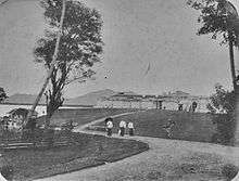
During Sukarno's imprisonment by the Dutch in the early 1930s, the future first president of Indonesia lived briefly in Bengkulu. Here he met his wife, Fatmawati, who bore him several children, one of whom, Megawati Sukarnoputri, became Indonesia's first female President. During early independence, Bengkulu was included in the older 'South Sumatera' Province with Lampung, the Bangka-Belitung Archipelago and what became South Sumatera itself, as a Residency. It finally gained its provincial status in 1968 as the 26th province (prior to the last province: East Timor).
Bengkulu lies near the Sunda Fault and is prone to earthquakes and tsunamis. The June 2000 Enggano earthquake killed at least 100 people. A recent report predicts that Bengkulu is "at risk of inundation over the next few decades from undersea earthquakes predicted along the coast of Sumatra"[8] A series of earthquakes struck Bengkulu during September 2007, killing 13 people.[9]
Geography and climate
Geographically, Bengkulu is located between 2° and 5° South Latitude and between 101° and 104° Eastern Longitude. The western part of Bengkulu province bordering the Indian Ocean coast that has a length of about 576 km and the eastern part of the condition is hilly with a plateau that is prone to erosion. Bengkulu Province is located in the west side of the Bukit Barisan mountains. The total area of Bengkulu province reached approximately 1.97887 million hectares or 19788.7 square kilometers. Bengkulu Province area extends from the border province of West Sumatra to the border province of Lampung and the distance is approximately 567 kilometers. Judging from its geographical situation, Bengkulu Province lies between 2 ° 16 '- 03 ° 31' latitude and 101 ° 01 '-103 ° 41' east longitude. Bengkulu province in the north bordering the province of West Sumatra, in the southern Indian Ocean and Lampung province, in the west bordering the Indian Ocean and in the east with the province of Jambi and South Sumatra Province.Bengkulu province bordered by the Indian Ocean coastline of approximately 525 kilometers. Its western part is hilly with fertile plateaus, while the western part is lowland relatively narrow, elongated from north to south and punctuated selangi bumpy areas.
Bengkulu climate is classified as tropical. Bengkulu has a large amount of rainfall throughout the year. This is true even for the driest month. The climate here is classified as Af by the Köppen-Geiger system. In Bengkulu, the annual average temperature is 26.8 °C. Within a year, the average rainfall is 3360 mm.
The total area of Bengkulu province is 19 788.7 km², in public administration Bengkulu province is divided into 8 districts and 1 town, consisting of 93 districts.
Population
| Historical population | ||
|---|---|---|
| Year | Pop. | ±% |
| 1971 | 519,316 | — |
| 1980 | 768,064 | +47.9% |
| 1990 | 1,179,122 | +53.5% |
| 1995 | 1,409,117 | +19.5% |
| 2000 | 1,567,436 | +11.2% |
| 2010 | 1,715,568 | +9.5% |
| 2014 | 1,828,291 | +6.6% |
| Source: Badan Pusat Statistik 2010 | ||
The 2010 census reported a population of 1,715,568[10] including 875,663 males and 837,730 females,[11] by January 2014 this had risen to 1,828,291.
Ethnic groups
Bengkulu is home to various indigenous ethnic groups. The Rejangs form the majority of the province with 60,4% of the population. The second largest ethnic group is the Javanese forming around 24%. Other minority indigenous ethnic groups includes Lembak, Serawai, Pekal, Enggano, Pasemah, Minangkabau and Malays. There is also non-indigenous ethnic groups that mostly came from other parts of Indonesia such as Sundanese, Javanese, Acehnese, Madurese, Batak, Chinese and others.
Religion
Islam forms majority of the population in the province with more than 95%. Christianity is the second largest religion with around 3% while the rest are Buddhist, Hindus (mostly Balinese migrants) and traditional beliefs.
Languages
As with other parts of Indonesia, Indonesian language is the official language in all formal occasions, institutions, and government affairs. However, local languages are still widely used in daily life. Most indigenous languages in Bengkulu belong to Malayan group of Austronesian languages such as Bengkulu Malay, Lembak, Pekal and Minangkabau varieties. The most widely spoken language in the province, Rejang, is unusual as it is the only Bornean language to be spoken in Sumatra (and one of three outside of Borneo other than Malagasy in Madagascar and Yakan in Basilan). Enggano's linguistic classification is still a debatable subject but currently it is classified as a highly divergent branch of Nuclear Malayo-Polynesian. Besides Enggano, there is also one less-studied language that is Nasal language, it maybe related to Rejang or forms its own branch of Malayo-Polynesian. Non-indigenous ethnic groups also speak their own language/dialects.
Administrative divisions
Bengkulu Province is subdivided into nine regencies and the independent city of Bengkulu, which lies outside any regency. The regencies and city are listed below with their populations at the 2010 Census and at the latest (January 2014) estimates.
| Name | Area (km2) | Population Census 2010 | Population Estimate 2014 | Capital | HDI[13] 2014 Estimates |
|---|---|---|---|---|---|
| Bengkulu City | 144.52 | 308,756 | 328,827 | Bengkulu | 0.764 (High) |
| Central Bengkulu Regency (Bengkulu Tengah) | * | 98,570 | 104,797 | Karang Tinggi | 0.641 (Medium) |
| Kaur Regency | 2,369.05 | 107,627 | 114,992 | Bintuhan | 0.637 (Medium) |
| Kepahiang Regency | 704.57 | 125,011 | 133,073 | Kepahiang | 0.652 (Medium) |
| Lebong Regency | 1,929.24 | 97,091 | 105,737 | Tubei | 0.639 (Medium) |
| Mukomuko Regency | 4,036.70 | 156,312 | 165,992 | Mukomuko | 0.653 (Medium) |
| North Bengkulu Regency (Bengkulu Utara) | 5,548.54 | 256,358 | 274,614 | Arga Makmur | 0.672 (Medium) |
| Rejang Lebong Regency | 1,475.99 | 246,378 | 263,010 | Curup | 0.665 (Medium) |
| Seluma Regency | 2,400.44 | 172,801 | 184,913 | Pasar Tais | 0.629 (Medium) |
| South Bengkulu Regency (Bengkulu Selatan) | 1,179.65 | 142,722 | 152,336 | Manna | 0.682 (Medium) |
| Totals | 19,919.33 | 1,715,568 | 1,828,291 | 0.680 (Medium) |
* – The area of Central Bengkulu Regency is included in the figure for North Bengkulu Regency, of which it was formerly part.

Economy
Three active coal mining companies produce between 200,000 and 400,000 tons of coal per year, which is exported to Malaysia, Singapore, South Asia, and East Asia. Fishing, particularly tuna and mackerel, is an important activity. Agricultural products exported by the province include ginger, bamboo shoots, and rubber.
See also
Notes
- ↑ "Statistik Indonesia 2018". Badan Pusat Statistik. Retrieved July 23, 2018.
- ↑ Bengkulu Lumbung Nasionalis yang Cair. epaper.kompas.com. February 11, 2009.
- ↑ "Indeks Pembangunan Manusia Metode Baru 2010–2014". Retrieved 13 March 2016.
- ↑ "Indeks Pembangunan Manusia Menurut Provinsi, 1996–2013". Retrieved 5 May 2016.
- ↑ "A History on the Honourable East India Company's Garrison on the West Coast of Sumatra 1685–1825". Retrieved May 10, 2016.
- ↑ "Bencoolen (Bengkulen)". Retrieved May 10, 2016.
- ↑ Roberts, Edmund (1837). Embassy to the Eastern Courts of Cochin-China, Siam, and Muscat. New York: Harper & Brothers. p. 34.
- ↑ Andrew C. Revkin (2006-12-05). "Indonesian Cities Lie in Shadow Of Cyclical Tsunami". The New York Times (Late Edition (East Coast)) p. A.5.
- ↑ New York Times
- ↑ Badan Pusat Statistik : Population of Indonesia by Province 1971, 1980, 1990, 1995 and 2000 Archived 2011-07-18 at the Wayback Machine. Retrieved 5 April 2010
- ↑ Jumlah Penduduk Bengkulu 1,7 Juta Jiwa | Harian Berita Sore
- ↑ "Population by Region and Religion in Indonesia". BPS. 2010.
- ↑ Indeks-Pembangunan-Manusia-2014
References
- Reid, Anthony (ed.). 1995. Witnesses to Sumatra: A traveller's anthology. Kuala Lumpur: Oxford University Press. pp. 125–133.
- Reprints of British-era primary source material
- Wilkinson, R.J. 1938. Bencoolen. Journal of the Malayan Branch Royal Asiatic Society. 16(1): 127–133.
- Overview of the British experience in Bencoolen
Places adjacent to Bengkulu | |
|---|---|
| Topics | |
|---|---|
| Regency of Bengkulu | |
| City of Bengkulu | |
| Major cities | |
| |
Capital: Jakarta | ||
| Sumatra |  | |
| Java | ||
| Kalimantan | ||
| Lesser Sunda | ||
| Sulawesi | ||
| Maluku | ||
| Papua | ||
| Former | ||
Lists by
| ||
| 2,000,000 and more | |
|---|---|
| 1,000,000-1,999,999 | |
| 400,000-999,999 | |
| 200,000-399,999 | |