Gorontalo
| Gorontalo Hulontalo | |||
|---|---|---|---|
| Province | |||
    | |||
| |||
| Nickname(s): Bumi Serambi Madinah (Medina's Porch) | |||
| Motto(s): Adati Hula-hula'a to Sara'a, Sara'a hula-hula'a to Kuru'ani (Tradition rooted in the Sharia, the Sharia rooted in the Quran) | |||
 Location of Gorontalo in Indonesia | |||
| Coordinates: 0°40′N 123°00′E / 0.667°N 123.000°ECoordinates: 0°40′N 123°00′E / 0.667°N 123.000°E | |||
| Country |
| ||
| Capital |
| ||
| Government | |||
| • Governor | Rusli Habibie (Golkar) | ||
| • Vice Governor | Idris Rahim | ||
| Area | |||
| • Total | 12.435 km2 (4.801 sq mi) | ||
| Population (2016)[1] | |||
| • Total | 1.133.237[2] | ||
| Demographics | |||
| • Ethnic groups | Gorontaloan, Atinggolan, Bolangoan, Suwawan, Mongondowi | ||
| • Religion (2017) |
Islam (96.66%) Protestantism (2.19%) Catholicism (0.69%) Hinduism (0.38%) Buddhism (0.08%)[3] | ||
| • Languages |
Indonesian (official) Gorontaloan (regional) | ||
| Time zone | UTC+08 (Indonesia Central Time) | ||
| Area code | +62 (435) | ||
| Vehicle registration | DM | ||
| Website | www.gorontaloprov.go.id | ||

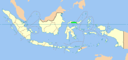
Gorontalo (Hulontalo) is an Indonesian province on the island of Sulawesi. It was created on December 5, 2000.[4] Historically, it has been a center for the spread of Islam in Eastern Indonesia. Besides, classical Gorontalese fine art and culture are unique such as Karawo, Upiya Karanji (Songkok Gorontalo) or nickname "Peci Gusdur" (Gusdur being the 4th President of Indonesia), and poetry.[5] (Gorontalo City is also known as "The Land Under Medina's Porch".) Gorontalo province is located on the peninsula (Gorontalo Peninsula) on the northern part of Sulawesi, located in the western part of the province of North Sulawesi. The total area of the province is 12,435 square kilometres (4,801 sq mi) with a population of 1,133,237 (2016), with population density of 88 inhabitants per km².[6] Gorontalo is mainly inhabited by several groups consisting of various Pohala'a (Family), among them Pohala'a Gorontalo (Ethnic Hulontalo), Pohala'a Suwawa (Ethnic Suwawa/Tuwawa), Pohala'a Limboto (Ethnic Limutu). Pohala'a Bolango (Ethnic Bulango/Bolango) and Pohala'a Atinggola (Ethnic Atinggola) are also categorized into Gorontalo tribes (also known as Hulontalo, Gorontalese or Gorontaloan). It is believed that the spread of Gorontalese diaspora has reached five times the current population in Gorontalo and are now scattered throughout Indonesia and other countries .[7]
History
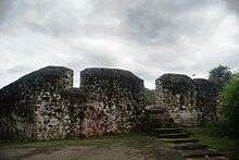
Gorontalo Peninsula has had some type of human civilization since approximately 1300 years ago. Historical records show a Kingdom of Suwawa as existing in 8th century CE.[8] This is reinforced by the discovery of the tomb of their king, Moluadu, on the banks of the river Bulawa along with his wife and child.[9]
However, Gorontalo Peninsula did not just have historical records on the inscription King ancient tombs, but it also has prehistoric sites. Oluhuta sites, is a prehistoric site and has a prehistoric tomb in it. this may be evidence that Gorontalo has had very ancient civilization.[10]
Meanwhile, the city of Gorontalo is one of the oldest cities on Sulawesi in addition to the city of Makassar and Manado. It is estimated, Gorontalo has been around since approximately 400 years ago or around the 1500s in the 16th century. Previously Gorontalo City became one of the centers of Islamic religion in Eastern Indonesia, in addition to Ternate (now part of North Maluku Province).[11]
Along with the spread of the religion, Gorontalo city eventually became the center of education and commerce for surrounding communities in the region "Tomini-Bocht" as Territory Bolaang Mongondow (North Sulawesi), Region Buol, Region Luwuk, Banggai, Donggala (Central Sulawesi) even to the Southeast. This is because of its strategic location, its position facing directly into the Gulf of Tomini (south) and the Sulawesi Sea (north).
Before the colonial period Gorontalo was governed under customary law. Kingdoms were united in a bond of kinship called "Pohala'a". According to Haga (1931) there are five pohala'a Gorontalo area:[12]
- Pohala'a Gorontalo
- Pohala'a Limboto
- Pohala'a Suwawa
- Pohala'a Bolango then be Pohala'a Boalemo
- Pohala'a Atinggola
Based on the classification made by the customs Mr.C.Vollenhoven, the Peninsula Gorontalo included into 19 indigenous areas in Indonesia.[13] Between religion and customs in Gorontalo was fused with the term "Adat bersendikan Syara 'and Syara' bersendikan Kitabullah". Pohalaa Gorontalo is the most prominent among the five Pohalaa. That is why Gorontalo is more widely known.
Prior to the onset of Indonesian independence, Nani Wartabone headed a Gorontalan Independence Movement, declaring itself sovereign on January 23rd, 1942.[14] For approximately two years Gorontalo was effectively a self-governing region. This was a milestone in the struggle for independence and inspired similar efforts both on Celebes and across the Indonesian archipelago. Wartabone was eventually recognized by the Indonesian Government as a National Hero of Indonesia. Today, he is buried in his hometown of Suwawa, in the eastern part of the province.
Old Cities in Gorontalo
Few other towns were known to be found in Gorontalo Province ever since the Dutch colonial era with the other old towns (in addition to the main city Gorontalo) such as:[15]
- Suwawa (Tuwawa)
- Limboto (Limutu)
- Tapa
- Tilamuta
- Kwandang
- Paguat
- Marisa
- Popayato
- Atinggola
Nicknames
Gorontalo has several nicknames:[16]
Etymology
Several hypotheses for the origin of the province's name abound[17]
- from Hulontalangio, the name of a tribe that once inhabited the area
- from Hua Lolontalango, meaning cavemen that walk back and forth
- from Hulutalangi, meaning nobler
- from Huluo Lo Tola, meaning a place where Snakehead (fish) breed
- from Pongolatalo or Pohulatalo, meaning a waiting place
- from Gunung Telu, meaning three mountains
- from Hunto, meaning a place with ever-present flowing water
Geography
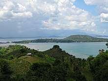
Gorontalo lies on the northern arm of Sulawesi Peninsula, also known as the Minahasa Peninsula. The province has an elongated shape area, stretching from west to east almost horizontally on a map, with a total area of 11,257.07 km2 (4,346.38 sq mi).[18] To the north and the south of the province lies the Sulawesi Sea and the Gulf of Gorontalo or known as Gulf of Tomini, respectively. Prior to Year 2000CE, Gorontalo province was part of North Sulawesi province which lies on the eastern border. The western border of the province is Central Sulawesi province.[19]
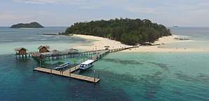
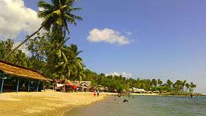
Topographically, the province is relatively low (0—40o), with the elevation ranging between 0—2,400 m (7,900 ft) above sea level. Its coastline length is more than 590 km (370 mi). Counting the Exclusive Economic Zone to the north where Philippines is at the border, the total sea area of the province is more than 50,500 km2 (19,500 sq mi).[18] There are some small islands around the north and the south of the province, 67 of which have been identified and named.[18]
Administrative divisions
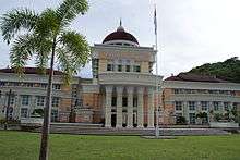
The governor and vice-governor, who are elected directly by the people, head the provincial administration. The province is divided into five regencies (Indonesian: kabupaten) and only one city (Indonesian: kota). When the province was established in 2000, there were only two regencies and the city in the province. Splitting of regencies occurred in 2003 (when Pohuwato Regency was created from the western part of Boalemo Regency, and Bone Bolango Regency was created from the eastern part of Gorontalo Regency) and 2007 (when North Gorontalo Regency was created from the northern part of Gorontalo Regency).
As of 2010, the list of regencies and cities in Gorontalo province is given in the table below.
| Name | Capital | Est. | Established by Statute | Area (km²) | Population Census 2010 | Population 2014 estimate | HDI[20] 2014 estimate |
|---|---|---|---|---|---|---|---|
| Gorontalo City | * | 1959 | UU 50/1959 | 79.59 | 180,127 | 196,464 | 0.749 (High) |
| Boalemo Regency | Tilamuta | 1999 | UU 50/1999 | 1,521.88 | 129,253 | 140,975 | 0.621 (Medium) |
| Bone Bolango Regency | Suwawa | 2003 | UU 6/2003 | 1,984.31 | 141,915 | 154,785 | 0.660 (Medium) |
| Gorontalo Regency | Limboto | 1959 | UU 29/1959 | 1,750.83 | 355,988 | 388,273 | 0.629 (Medium) |
| North Gorontalo Regency (Gorontalo Utara) | Kwandang | 2007 | UU 11/2007 | 1,676.15 | 104,133 | 113,577 | 0.619 (Medium) |
| Pohuwato Regency | Marisa | 2003 | UU 6/2003 | 4,244.31 | 128,748 | 140,424 | 0.617 (Medium) |
Note: * A city and also the provincial capital.
| Historical population | ||
|---|---|---|
| Year | Pop. | ±% |
| 1971 | 490,521 | — |
| 1980 | 600,323 | +22.4% |
| 1990 | 715,508 | +19.2% |
| 2000 | 835,044 | +16.7% |
| 2010 | 1,040,164 | +24.6% |
| Source: Statistics Indonesia 2010. Gorontalo part of North Sulawesi Province until 2000 | ||
Demographics
Religion
| Regency/City | Islam | Christian | Chatolic | Hinduism | Buddhism | Konghucu | Folk |
|---|---|---|---|---|---|---|---|
| Boalemo | 95.81% | 1.47% | 0.90% | 0.82% | 0.03% | 0.00% | 0.00% |
| Bone Bolango | 99.61% | 0.26% | 0.12% | 0.01% | 0.00% | 0.00% | 0.00% |
| Gorontalo | 99.11% | 0.57% | 0.29% | 0.02% | 0.01% | 0.00% | 0.00% |
| North Gorontalo | 93.88% | 5.37% | 0.74% | 0.01% | 0.00% | 0.00% | 0.00% |
| Pohuwato | 92.91% | 4.92% | 1.19% | 0.96% | 0.00% | 0.00% | 0.00% |
| Gorontalo City | 96.00% | 3.99% | 1.32% | 0.12% | 0.47% | 0.00% | 0.00% |
| Gorontalo | 96.66% | 2.19% | 0.69% | 0.38% | 0.08% | 0.00% | 0.00% |
Like many Indonesian provinces, Gorontalo has a large majority of Muslims.
References
- ↑ "Gorontalo Profile" (Press release). Statistics Indonesia. Archived from the original on 24 August 2007. Retrieved 27 August 2007.
- ↑ Gorontalo, BPS. "Jumlah Penduduk". BPSP Gorontalo. Retrieved 3 February 2017.
- ↑ "Persentase Penduduk Menurut Kabupaten/Kota dan Agama di Provinsi Gorontalo, 2016". Badan Pusat Statistik (BPS). Retrieved December 8, 2017.
- ↑ Gorontalo, Pemprov. "HUT Provinsi Gorontalo". Retrieved 8 February 2017.
- ↑ Karanji, Upiya. "Upiya Karanji". Retrieved 8 February 2017.
- ↑ BPS, publikasi. "BPS Gorontalo". Retrieved 8 February 2017.
- ↑ "Informasi Daerah". Kemendag. Retrieved 8 February 2017.
- ↑ Suwawa, Kerajaan. "suwawa kingdom". Retrieved 8 February 2017.
- ↑ "Bahasa Bonda dan Kubur Keramat". Retrieved 8 February 2017.
- ↑ "Situs Oluhuta". Retrieved 8 February 2017.
- ↑ "Kota Tua Gorontalo". Retrieved 8 February 2017.
- ↑ "Sejarah Gorontalo". Retrieved 8 February 2017.
- ↑ "Daerah Adat Indonesia". Archived from the original on 11 February 2017. Retrieved 8 February 2017.
- ↑ "Sejarah Gorontalo". Retrieved 8 February 2017.
- ↑ "Bahasa Daerah Gorontalo". regional.kompas.com. Retrieved 8 February 2017.
- ↑ "Julukan lain Gorontalo". Dedi Panigoro. Retrieved 8 February 2017.
- ↑ "The History of Province of Gorontalo". Sejarah Provinsi Gorontalo (in Indonesian). Statistics Bureau of Province of Gorontalo. Archived from the original on 30 January 2009. Retrieved 2008-10-10.
- 1 2 3 "Geographical Condition". Gorontalo ~ Provinsi Agropolitan (in Indonesian). Provincial Government of Gorontalo. Archived from the original on 2007-07-16. Retrieved 2007-08-27.
- ↑ "Batas Provinsi Gorontalo". Retrieved 8 February 2017.
- ↑ Indeks-Pembangunan-Manusia-2014
- ↑ "Persentase Penduduk Menurut Kabupaten/Kota dan Agama di Provinsi Gorontalo, 2016". Badan Pusat Statistik (BPS). Retrieved December 8, 2017.
- ↑ "Population by Region and Religion in Indonesia". BPS. 2010.
Capital: Jakarta | ||
| Sumatra |  | |
| Java | ||
| Kalimantan | ||
| Lesser Sunda | ||
| Sulawesi | ||
| Maluku | ||
| Papua | ||
| Former | ||
Lists by
| ||