South Tangerang
| South Tangerang | ||
|---|---|---|
| City | ||
|
City of South Tangerang Kota Tangerang Selatan | ||
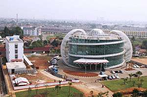 Surya Research Education Center Building, Serpong, South Tangerang | ||
| ||
|
Motto(s): Cerdas, Modern, Religius (Intelligent, Modern, Religious) | ||
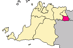 Location within Banten | ||
| Coordinates: 6°17′20″S 106°43′05″E / 6.28889°S 106.71806°ECoordinates: 6°17′20″S 106°43′05″E / 6.28889°S 106.71806°E | ||
| Country |
| |
| Province |
| |
| Government | ||
| • Mayor | Airin Rachmi Diany | |
| • Vice Mayor | Drs. Benyamin Davnie MSi | |
| Area | ||
| • Total | 147.19 km2 (56.83 sq mi) | |
| • Land | 123.58 km2 (47.71 sq mi) | |
| • Water | 23.61 km2 (9.12 sq mi) | |
| Population (2014 estimate) | ||
| • Total | 1,436,187 | |
| • Density | 9,800/km2 (25,000/sq mi) | |
| Time zone | UTC+7 (Indonesia Western Time) | |
| Postcodes | 1xxxx | |
| Area code | (+62) 21 | |
| Website | www.tangerangselatankota.go.id | |


South Tangerang is a city in the province of Banten, Indonesia. Located on the southwestern border of Jakarta, the city forms part of the Greater Jakarta metropolitan area. It was administratively seceded from Tangerang Regency on 29 October 2008.[1] According to the 2010 Census, its population was 1,303,569, while the latest estimate in 2014 is 1,436,187. The total area is 147.19 km².[2]
Administration
The municipality of South Tangerang is divided into seven districts (kecamatan), tabulated below with their 2012 Census population. The centre of South Tangerang is the Ciputat district. The districts are sub-divided into 49 administrative villages (kelurahan) and five villages (desa). The district with the highest number of kelurahan or desa is Pondok Aren.[3]
| Name | Population Census 2010 |
|---|---|
| Serpong | 137,212 |
| Serpong Utara (North Serpong) | 126,499 |
| Pondok Aren | 303,093 |
| Ciputat | 192,205 |
| Ciputat Timur (East Ciputat) | 178,818 |
| Pamulang | 286,270 |
| Setu | 66,225 |
Transportation
The city is served mainly by land transportation. Buses, minibuses and taxis are the main methods of transportation available. The public transportation mostly goes to Jakarta since many of the residents of South Tangerang commute into Jakarta. There are feeder buses for TransJakarta. The feeder buses are from Bumi Serpong Damai and Bintaro Jaya to downtown Jakarta in Senayan.
The city is also served by KRL Jabotabek for the commuters who work in Jakarta, and by intercity service from PT Kereta Api Indonesia. KRL Jabotabek is operated by subsidiary of PT Kereta Api Indonesia for the commuter line in Greater Jakarta metropolitan area.
There are two toll roads servicing the city, namely Jakarta–Serpong Toll Road and Jakarta–Tangerang Toll Road. There are also several toll roads currently under planning. The plans are for a Serpong-Balaraja Toll Road which will continue the Jakarta-Serpong toll road, and Jakarta Outer Ring Road 2 which will be connecting the city to Soekarno–Hatta International Airport in the near future.
Pondok Cabe Airport – which is used for military and civilian services – is the only airport located within the city boundaries. It is owned by PT Pertamina, the national oil company. The airport is also used for the maintenance base for Pelita Air Service, also owned by PT Pertamina.
Cycle rickshaws (becak) are still available in some areas in the city. Becak is the only method of transportation currently forbidden to operate in Jakarta as its slow speed has allegedly led to congestion in the traffic of Jakarta. However, since South Tangerang is located on the outskirts of Jakarta (instead of the city proper), it is allowed in the city.
On October 10, 2013, a Memorandum of Understanding has been signed by PT Petras Indonesia and PT Banten Global Development to make a join venture PT Banten Monorel to build Serpong to Soekarno–Hatta International Airport monorail with more than 35 kilometers length, predicted Rp12,000 billion cost and ground breaking is planned to be done on August 17, 2014.[4]
In April 2015, Corridor-2 of Trans Anggrek Circle Line which is similar to TransJakarta has been launched to serve public from Pondok Cabe Terminal to Rawa Buntu Station of KRL Jabodetabek. It's free until end of 2015, but only operate between 06:00-09:00, 11:00-14:00 and 16:00-18:00 with notation time of serve will be added as needed. The other 7 corridors will be applied gradually.[5]
Education
Education in South Tangerang is just as the same as the other part of Indonesia, which is from elementary until senior high (compulsory). Here are the list of schools and universities in South Tangerang :
International Schools
- Jakarta Japanese School, (Bintaro Jaya)
- Global Jaya International School, (Bintaro Jaya)
- German International School Jakarta (BSD City)
- Sinarmas World Academy (BSD City)
- British School Jakarta (Bintaro Jaya)
- Jakarta Nanyang School (BSD City)
- BINUS Serpong, Cambridge International School (BSD City)
Other Schools
- IPEKA BSD Christian School
- Santa Ursula BSD
- BPK Penabur Gading Serpong
- Santa Laurensia School (Alam Sutera)
- BPK Penabur Bintaro Jaya
- SMA Tarakanita Gading Serpong
- SMA Plus Pembangunan Jaya
- SMA Efata Serpong
- SMA Candle Tree
- SMA Islam Cikal Harapan BSD
- SMA Stella Maris BSD
- SMA Islam Al Azhar BSD
- PAHOA Gading Serpong
- Saint John Catolic School BSD
- Sekolah Athalia
Public universities
Government-affiliated colleges
- Sekolah Tinggi Akutansi Negara
- Geophysics and Meteorology Academy (Akademi Meteorologi dan Geofisika)[6]
Private Universities
- Swiss German University
- Pamulang University (Universitas Pamulang)[7]
- Muhammadiyah Jakarta University (Universitas Muhammadiyah Jakarta)[8]
- Surya University in Gading Serpong[9]
- Indonesian Institute of Technology (Institut Teknologi Indonesia)[10]
- Prasetiya Mulya Business School
- Multimedia Nusantara University
- Bina Nusantara University
- International University Liaison Indonesia
Twin towns – sister cities
South Tangerang is twinned with:
See also
References
- ↑ Hari Lahir Kota Tangerang Selatan Ditetapkan
- ↑ "Kondisi Geografis dan Iklim".
- ↑ Pemerintahan
- ↑ "Monorel Serpong–Bandara Dianggarkan Rp12 Triliun". October 11, 2013.
- ↑ "Tangerang Selatan Uji Coba Lima Bus Gratis "Trans Anggrek Circle Line"". April 13, 2015.
- ↑ "Archived copy". Archived from the original on 2012-04-20. Retrieved 2012-04-17.
- ↑ http://www.unpam.ac.id/
- ↑ "Archived copy". Archived from the original on 2012-04-18. Retrieved 2012-04-17.
- ↑ http://surya.ac.id/
- ↑ http://iti.ac.id/
External links
| Wikivoyage has a travel guide for South Tangerang. |
- (in Indonesian)Official website
- (in Indonesian)Tangsel Official website
| 2,000,000 and more | |
|---|---|
| 1,000,000-1,999,999 | |
| 400,000-999,999 | |
| 200,000-399,999 | |