Mentawai Strait
| Mentawai Strait Indonesian: Selat Mentawai | |
|---|---|
 Mentawai Strait | |
 Mentawai Strait | |
| Coordinates | 1°45′00″S 100°0′0″E / 1.75000°S 100.00000°ECoordinates: 1°45′00″S 100°0′0″E / 1.75000°S 100.00000°E |
| Type | strait |
| Basin countries |
|
| Max. length | 450 kilometres (280 mi) |
| Max. width | 150 kilometres (93 mi) |
| Min. width | 100 kilometres (62 mi) |
| Settlements | Padang |
| References | Selat Mentawai: Indonesia National Geospatial-Intelligence Agency, Bethesda, MD, USA |
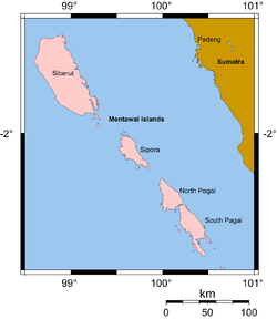
Mentawai Strait separates the island of Sumatra from the small archipelago of the Mentawai Islands, Indonesia. Its waters belong to the Indian Ocean and both banks are part of the province of West Sumatra.
The strait is about 450 km long and its width varies between 100 and 150 km. The main city on the edge of the strait is the capital of West Sumatra, Padang.
The strait is in major fault zone and several earthquakes have been located in it, being the most known those of 1833 Sumatra earthquake and that of 2009 Sumatra earthquake.
See also
References
This article is issued from
Wikipedia.
The text is licensed under Creative Commons - Attribution - Sharealike.
Additional terms may apply for the media files.