IRT New Lots Line
| IRT New Lots Line | |
|---|---|
  | |
| Overview | |
| Type | Rapid transit |
| System | New York City Subway |
| Status | Operating |
| Locale | Brooklyn |
| Termini |
Sutter Avenue–Rutland Road New Lots Avenue |
| Stations | 7 |
| Daily ridership | 73,760[1] |
| Operation | |
| Opened | 1920-1922 |
| Owner | City of New York |
| Operator(s) | New York City Transit Authority |
| Character | Elevated |
| Technical | |
| Line length | 4.91 miles (7.90 km) |
| Number of tracks | 2-3 |
| Track gauge | 1,435 mm (4 ft 8 1⁄2 in) standard gauge |
| Electrification | 600V DC third rail |
IRT New Lots Line | |||||||||||||||||||||||||||||||||||||||||||||||||||||||||||||||||||||||||||||||||||||||||||||||||||||||||||||||||||||||||||||||||||||||||||||||||||||||||||||||
|---|---|---|---|---|---|---|---|---|---|---|---|---|---|---|---|---|---|---|---|---|---|---|---|---|---|---|---|---|---|---|---|---|---|---|---|---|---|---|---|---|---|---|---|---|---|---|---|---|---|---|---|---|---|---|---|---|---|---|---|---|---|---|---|---|---|---|---|---|---|---|---|---|---|---|---|---|---|---|---|---|---|---|---|---|---|---|---|---|---|---|---|---|---|---|---|---|---|---|---|---|---|---|---|---|---|---|---|---|---|---|---|---|---|---|---|---|---|---|---|---|---|---|---|---|---|---|---|---|---|---|---|---|---|---|---|---|---|---|---|---|---|---|---|---|---|---|---|---|---|---|---|---|---|---|---|---|---|---|---|
| |||||||||||||||||||||||||||||||||||||||||||||||||||||||||||||||||||||||||||||||||||||||||||||||||||||||||||||||||||||||||||||||||||||||||||||||||||||||||||||||
The IRT New Lots Line or Livonia Avenue Line[2]:129 is a rapid transit line in the IRT A Division of the New York City Subway. Located in the New York City borough of Brooklyn, the line runs from Utica Avenue in Crown Heights and continues to New Lots Avenue in East New York.[3][4][5]
History
Opening
This line was built as a part of the Dual Contracts.[6] It was built as an elevated line because the ground in this area is right above the water table, and as a result the construction of a subway would have been prohibitively expensive.[7]
Toward the end of 1919, work on the Livonia Avenue Line was suspended because of the default of a contractor who had the contract for the erection of steel. During 1919, the city purchased an area of land bounded by Hegeman and Lawrence Avenues, and Elton and Linwood Streets. Contracts for the yard were awarded in 1920.[6]
The first portion of the line between Utica Avenue and Junius Street opened on November 22, 1920, with shuttle trains operating over this route.[8][9] The line opened one more stop farther to the east to Pennsylvania Avenue on December 24, 1920.[9] At that date, only the southbound platform was used.[2]:129 In 1921, the stations at Van Siclen Avenue and New Lots Avenue were practically completed, but they were not opened yet because trains could not run to the terminal until track work, the signal tower, and the compressor room were in service.[10]:129-130 Work began on June 19, 1922 and shuttles started operating between Pennsylvania Avenue and New Lots Avenue on October 16, 1922.[9] A two-car train operated on a single track on the northbound track.[11]
Work on the contract for installation of tracks in Livonia Yard began on May 18, 1922 and was completed on July 18, 1922. The yard was built with inspection facilities and the ability to store 250 cars. Work was completed on December 31, 1922, and the yard was opened for service on July 28, 1923. On October 31, 1924, through service to New Lots Avenue was begun.[11]
Expansion plans
On March 1, 1951, the New York City Board of Transportation announced that it would conduct an engineering study for the construction of a third track between Utica Avenue and New Lots Avenue using the unused trackbed in the center of the elevated structure.[12]
In 1968, as part of the proposed Program for Action, the IRT New Lots Line in East New York, would be extended southerly through the Livonia Yard to Flatlands Avenue to a modern terminal at Flatlands Avenue and Linwood Street. This line would have run at ground level and it would have provided better access to the then-growing community of Spring Creek. This extension would have been completed at the cost of $12 million.[13][14]
Service changes
2 and 3 trains kept on switching their southern terminals until July 10, 1983, when the 2 was sent to Flatbush Avenue and the 3 to New Lots Avenue, which remains the current service pattern. The purpose of this switch was so that the 3 would readily have access to the shops at Livonia Yard. 4 trains were added on December 20, 1946, and 5 trains were gradually added between 1938 and 1950.
Extent and service
The following services use part or all of the IRT New Lots Line:[15]
| Time period | |||
|---|---|---|---|
| rush hours | middays, evenings, and weekends | late nights | |
| limited service | no service | ||
| service | no service | ||
| limited service | no service | service | |
| limited service | no service | ||
The line is served by the 3 train at all times except late nights, when the 4 train takes over service. Some rush hour 2 and 5 trains also run on this line because of capacity issues at their usual terminal at Flatbush Avenue–Brooklyn College on the IRT Nostrand Avenue Line.
Route description
The New Lots Line is the only elevated structure on the Brooklyn IRT. The line begins just east of Utica Avenue in Crown Heights, branching off from the IRT Eastern Parkway Line. The line then emerges from a tunnel on the southeast corner along the eastern edge of Lincoln Terrace Park, the IRT New Lots Line then crosses a bridge over East New York Avenue and then runs over East 98th Street with only one station, until it approaches the intersection with Livonia Avenue, where the line moves over that road, and remains as such almost entirely. Right after Junius Street Station, Livonia Avenue is bisected by the Long Island Rail Road Bay Ridge Branch as well as the Linden Shops, both of which run between Junius Street and Van Sinderin Avenue, the latter of which is flanked by the BMT Canarsie Line, also an elevated line, but runs underneath the New Lots Line. The last station on the line is New Lots Avenue, which is actually two blocks west of the eastern terminus of Livonia Avenue at the street the station is named for. The New Lots Line crosses over New Lots Avenue and then Elton Street, curving to the south and terminating within the Livonia Yard.[16][3][4][5] There is a provision for a future extension from New Lots Avenue in the elevated structure at Linwood Avenue.[9]
The line includes an unused trackway in the middle that was built as a provision for a third track.[17]:2389 On the roof of the mezzanines at each station are cross ties but no rails. In some areas, the space is used for mechanical and signal rooms. A center track exists only at Junius Street, where it crosses the southbound track at grade towards the Linden Shops. This un-electrified track is one of only two connections to the national rail system. The BMT West End Line is the other connection, via the New York Connecting Railroad; the Linden Shops are connected to the Long Island Rail Road and from there to the rest of the national network.[16] There are plans to renovate the elevated structure, including new mezzanines and stairs.
Station listing
| Station service legend | |
|---|---|
| Stops all times except late nights | |
| Stops late nights only | |
| Stops rush hours only | |
| Time period details | |
| Station is compliant with the Americans with Disabilities Act | |
| Station is compliant with the Americans with Disabilities Act in the indicated direction only | |
| Elevator access to mezzanine only | |
| Neighborhood (approximate) |
Station | Services | Opened | Transfers and notes | |
|---|---|---|---|---|---|
| Begins as continuation of IRT Eastern Parkway Line local tracks (2 | |||||
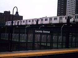
| Brownsville | Sutter Avenue–Rutland Road | 2 |
November 22, 1920[17]:2390 | B15 bus to JFK Airport | |
| Saratoga Avenue | 2 |
November 22, 1920[17]:2390 | |||
| Rockaway Avenue | 2 |
November 22, 1920[17]:2390 | |||
| Junius Street | 2 |
November 22, 1920[17]:2390 | |||
| connecting track to Linden Shops (non-electrified) | |||||
| East New York | Pennsylvania Avenue | 2 |
December 24, 1920[17]:2390 | ||
| Van Siclen Avenue | 2 |
October 16, 1922 | |||
| New Lots Avenue | 2 |
October 16, 1922 | B15 bus to JFK Airport | ||
| Terminus of all service | |||||
| Connecting tracks to Livonia Yard | |||||
References
- ↑ MTA. "Average weekday subway ridership". Archived from the original on March 28, 2014. Retrieved April 2, 2014.
- 1 2 Annual Report. J.B. Lyon Company. 1922.
- 1 2 Metropolitan Transportation Authority, 2005 Adopted Budget - February Financial Plan 2005–2008, "Section VII: MTA Capital Program Information" (PDF). (91.7 KiB): shows Utica Avenue on "EPK" and Sutter Avenue on "NLT"
- 1 2 Metropolitan Transportation Authority, 2005 Final Proposed Budget - November Financial Plan 2005–2008, "Section VI: MTA Capital Program Information" (PDF). (1.02 MiB): "Sutter Avenue Portal to end"
- 1 2 In a 1981 list of "most deteriorated subway stations", the MTA listed Borough Hall and Court Street stations as part of the New Lots Line:
New York Times, Agency Lists Its 69 Most Deteriorated Subway Stations, June 11, 1981, section B, page 5 - 1 2 "Nearly 70 Track Miles to Be Added To Rapid Transit Facilities in 1920". Brooklyn Standard Union. December 28, 1919. Retrieved August 14, 2016 – via Fulton History.
- ↑ "Differ Over Assessment Plans in Transit Projects: Eastern Parkway Subway and Livonia Avenue Extension the Cause of Bitter Dissension Among Property Owners Uptown". The Daily Standard Union. March 13, 1910. Retrieved August 14, 2016 – via Fulton History.
- ↑ "Annual report. 1920-1921". HathiTrust. Interborough Rapid Transit. Retrieved September 5, 2016.
- 1 2 3 4 Cunningham, Joseph; DeHart, Leonard O. (1993). A History of the New York City Subway System. J. Schmidt, R. Giglio, and K. Lang. p. 53.
- ↑ Commission, New York (State) Transit (1922). Annual Report ... J.B. Lyon Company.
- 1 2 "IRT Brooklyn Line Opened 90 Years Ago". New York Division Bulletin. New York Division, Electric Railroaders' Association. 53 (9). September 2010. Retrieved August 31, 2016 – via Issu.
- ↑ Ingraham, Joseph C. (March 2, 1951). "Faster I.R.T. Service in the Bronx To Cut East Side Run 13 Minutes" (PDF). p. 1. Retrieved October 7, 2016.
- ↑ "Full text of "Metropolitan transportation, a program for action. Report to Nelson A. Rockefeller, Governor of New York."". Internet Archive. November 7, 1967. Retrieved October 1, 2015.
- ↑ Feinman, Mark. "The New York Transit Authority in the 1970s". nycsubway.org. Retrieved April 23, 2015.
- ↑ "Subway Service Guide" (PDF). Metropolitan Transportation Authority. June 25, 2017. Retrieved July 1, 2017.
- 1 2 Dougherty, Peter (2006) [2002]. Tracks of the New York City Subway 2006 (3rd ed.). Dougherty. OCLC 49777633 – via Google Books.
- 1 2 3 4 5 6 Moodys Manual of Railroads and Corporation Securities. Moody Manual Company. 1922.
External links
Route map:

| Current services |
| ||||||||||
|---|---|---|---|---|---|---|---|---|---|---|---|
| Defunct services |
| ||||||||||
| Unused labels | |||||||||||
| Stations |
| ||||||||||
| Divisions | |||||||||||
| Other lists | |||||||||||
| History |
| ||||||||||
| Infrastructure | |||||||||||
| Arts and culture | |||||||||||
| Miscellaneous | |||||||||||
| Other rapid transit in NYC |
| ||||||||||
| New Lots Line | |
|---|---|
| |