Atlantic Terminal
Atlantic Terminal | |||||||||||
|---|---|---|---|---|---|---|---|---|---|---|---|
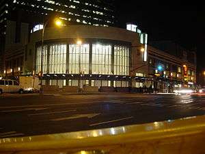 The terminal's entrance pavilion, opened 2010 | |||||||||||
| Location |
Atlantic Avenue, Flatbush Avenue & Hanson Place Brooklyn, New York | ||||||||||
| Coordinates | 40°41′03″N 73°58′38″W / 40.684226°N 73.977234°WCoordinates: 40°41′03″N 73°58′38″W / 40.684226°N 73.977234°W | ||||||||||
| Owned by | Long Island Rail Road | ||||||||||
| Line(s) | |||||||||||
| Platforms | 3 island platforms | ||||||||||
| Tracks | 6 | ||||||||||
| Connections |
New York City Subway: | ||||||||||
| Construction | |||||||||||
| Disabled access | Yes | ||||||||||
| Other information | |||||||||||
| Fare zone | 1 | ||||||||||
| History | |||||||||||
| Opened | July 2, 1877 | ||||||||||
| Rebuilt | 1907, 2010 | ||||||||||
| Electrified |
July 26, 1905 750 V (DC) third rail | ||||||||||
| Previous names |
Brooklyn (1852–1877) Flatbush Avenue (1877–2010) | ||||||||||
| Traffic | |||||||||||
| Passengers (2010) | 27,850[1] | ||||||||||
| Services | |||||||||||
| |||||||||||
Atlantic Terminal (formerly Flatbush Avenue) is the westernmost stop on the Long Island Rail Road's (LIRR) Atlantic Branch, located at Flatbush Avenue and Atlantic Avenue in Downtown Brooklyn, New York City. It is the primary terminal for the Far Rockaway, Hempstead, and West Hempstead Branches. The terminal is located in the City Terminal Zone, the LIRR's Zone 1, and thus part of the CityTicket program.
History
The station was originally named Brooklyn in 1852,[2] twenty years after the line was established as the Brooklyn and Jamaica Railroad, and wasn't originally a terminus.[2] The original terminus was South Ferry. When LIRR subsidiary New York and Jamaica Railroad built a new line between Hunter's Point and Jamaica in 1861, the main line was relocated there, and the line was abandoned west of East New York, in compliance with Brooklyn's ban on steam railroads. West of East New York, the tracks were taken over by horse car lines.
The Brooklyn station designation was replaced by the Flatbush Avenue station on July 2, 1877. That same summer local Atlantic Avenue rapid transit trains began to stop there on August 13.[3] The old depot was renovated between July–August 1878, when it began serving the Brooklyn, Flatbush and Coney Island Railroad. It was rebuilt again in June 1880. The headquarters for the Long Island Express Company was installed there in 1882, and gave the station a series of tracks that would later be known as the "EX Yard." In 1888, the Union Elevated Railway built an elevated railway line and station that connected to the LIRR station, which was better known as the Atlantic Avenue (BMT Fifth Avenue Line). The Union Elevated eventually became part of the Brooklyn-Manhattan Transit Corporation. Further rebuilding took place again in 1893.
Between 1904 and 1906, the Carlton Avenue Freight Yards were replaced by the Vanderbilt Avenue Freight Yards. This was just a portion of a major improvement project that included the complete reconstruction of the station. The second depot opened on April 1, 1907 with the depot at street level and the tracks installed underground. The station had a lobby that was larger than most LIRR stations, and contained subway type entrances to the tracks.[4] It also served as a post office building until 1925,[5] and contained a baggage depot, express buildings, some meat houses which were inherited from the previous version of the station, and a merchandise terminal for "less than carload freight" added on in 1908. The Interborough Rapid Transit Company built a subway line called the Eastern Parkway Line and a station on Atlantic Avenue, that connected to the station on May 1, 1908. The BMT also built two more subway lines on Pacific Street along the Fourth Avenue Line on June 22, 1915, and Atlantic Avenue along the Brighton Line on August 1, 1920. The connection to the BMT Fifth Avenue Line was lost on May 31, 1940.[6]
The station was refurbished and the exterior was sandblasted in the early 1940s. The decline of rail service after World War II led to the station's gradual demise, however. Track #1 was out of service on April 10, 1959. Former express tracks numbers 9-14 ("EX" Yard) were taken out of service on March 3, 1971. At some point, the express buildings became a parking garage. Local businesses were still allowed to utilize the station, such as a barber shop, restaurants, candy stores, a snack bar, a podiatrist's office, a dental office, a beauty school, and even a row of telephone booths. Those businesses were gone by 1978. The tracks that were originally numbered from south to north were renumbered from north to south on July 1, 1978. Despite efforts to repaint the lobby in the early-1980s, random vandalism plagued the station interior causing water damage that was so severe, the street level depot was closed in 1988, and portions were razed during the 1990s.
On January 5, 2010, a new entry pavilion, designed by di Domenico + Partners, opened, providing improved connections between the LIRR, subways, and buses.[7] In March 2010, the station was renamed Atlantic Terminal after a six-year reconstruction project,[8] during which trains continued to operate.
In 2014, the LIRR announced that service from Babylon and Hicksville will go directly to Atlantic Terminal during New York Islanders games at Barclays Center. Passengers would normally have to transfer at Jamaica to go to Babylon or Hicksville.[9] However, in preparation for East Side Access project, most service to Atlantic Terminal will be provided by a high-frequency shuttle service to and from Jamaica.[10]
Accident
During the morning rush hour of January 4, 2017, a train overran the bumper block at the end of track 6, injuring 103, none seriously.[11][12][13] There were 650 passengers on the train, which had originated from Far Rockaway.[14] The incident was compared to a September 2016 train crash at Hoboken Terminal in Hoboken, New Jersey, wherein a train also overran a bumper block.[11] The accident occurred at about 8:20 a.m. Two carriages of the six-carriage electric multiple unit involved were severely damaged when it collided with the buffer stop at a speed of 10 to 15 miles per hour (16 to 24 km/h).[12][15] The National Transportation Safety Board and Federal Railway Administration opened investigations into the accident.[12]
Station layout
The LIRR terminal, one floor below the ground level, has three high-level island platforms adjacent to six tracks. Platform A is ten cars long, but the two eastern-most cars on Track 1 are not accessible due to a large gap between the train and the platform. Platform B is eight cars long. Platform C is six cars long, but Track 6 only has enough space for four cars to meet the platform as it is adjacent to the northbound local platform of the IRT Eastern Parkway Line.
| G | Street Level | Entrances/Exits, pavilion, station house, fare control, station agents, LIRR ticket booth, MetroCard machines, connection to Long Island Rail Road |
| Barclays Center | ||
| Connection to Atlantic Terminal shopping mall | ||
| B1 Eastern Parkway Line platforms |
Side platform, doors will open on the right | |
| Northbound local | ← ← ← | |
| Northbound express | ← ← | |
| Island platform, doors will open on the left | ||
| Southbound express | → → | |
| Southbound local | → → | |
| Side platform, doors will open on the right | ||
| B1 LIRR platforms |
Track 1 | Atlantic Branch toward Long Island (Nostrand Avenue) → |
| Platform A, doors will open on the left, right | ||
| Track 2 | Atlantic Branch toward Long Island (Nostrand Avenue) → | |
| Track 3 | Atlantic Branch toward Long Island (Nostrand Avenue) → | |
| Platform B, doors will open on the left, right | ||
| Track 4 | Atlantic Branch toward Long Island (Nostrand Avenue) → | |
| Track 5 | Atlantic Branch toward Long Island (Nostrand Avenue) → | |
| Platform C, doors will open on the left, right | ||
| Track 6 | Atlantic Branch toward Long Island (Nostrand Avenue) → | |
| B2 | Mezzanine | Passageway between platforms |
| B3 Brighton Line platform (Atlantic Avenue) |
Northbound | ← ← |
| Island platform, doors will open on the left | ||
| Southbound | → → | |
| B3 Fourth Avenue Line Platforms (Pacific Street) |
Northbound local | ← ← ← |
| Island platform, doors will open on the left, right | ||
| Northbound express | ← ← | |
| Southbound express | → → | |
| Island platform, doors will open on the left, right | ||
| Southbound local | → → → | |
Subway and bus connections
Atlantic Terminal is connected to the New York City Subway's Atlantic Avenue–Barclays Center complex, which is served by the 2, 3, 4, 5, B, D, N, Q, R and W trains.[16] Buses serving outside the complex include B41, B45, B63, B65, B67, and B103.[17]
Nearby points of interest
The rail terminal is adjacent to and below the Atlantic Terminal mall and near the Barclays Center, Brooklyn Academy of Music and the Williamsburgh Savings Bank Tower, as well as Brooklyn Technical High School.
The massive Pacific Park residential, commercial and sports complex (including Barclays Center) is being built near the station and above its yard tracks.[18]
Gallery
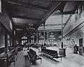 Interior of the station, c. 1893
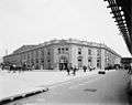 1910 photo of the former LIRR Atlantic Terminal (demolished 1988)
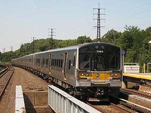
 Looking down Platform A. A train to Far Rockaway is on the right
 Looking down to track level in entry pavilion
See also
References
- ↑ Average weekday, 2010 LIRR Annual Ridership and Marketing Report
- 1 2 "Long Island Station History". Retrieved April 21, 2016.
- ↑ "rapid transit". Retrieved April 21, 2016.
- ↑ "FLATBUSH AVENUE TERMINAL 3 - INTERIOR". Retrieved April 21, 2016.
- ↑ "Postal History". Retrieved April 21, 2016.
- ↑ Ministry of Travel: The New LIRR Brooklyn Terminal; Forgotten New York
- ↑ "New LIRR Atlantic Terminal Pavilion Opens To The Public" (Press release). Long Island Rail Road. January 5, 2010. Retrieved July 16, 2013.
- ↑ "This new LIRR terminal is on a roll". The Brooklyn Paper. Retrieved April 21, 2016.
- ↑ Castillo, Alfonso A. (September 20, 2014). "LIRR, Barclays Center work to get Islanders fans to come to Brooklyn". Newsday. Retrieved April 22, 2015.
- ↑ Kulick, Beth (2014). "Jamaica Interlocking Reconfiguration Operations Simulation" (PDF). apta.com. TranSystems Corporation. Retrieved February 5, 2018.
- 1 2 "Officials: More than 100 hurt in LIRR train derailment". Newsday. January 4, 2017. Retrieved January 4, 2017.
- 1 2 3 "Officials: More than 100 hurt in LIRR train derailment". Newsday. January 4, 2017. Retrieved January 4, 2017.
- ↑ Siff, Andrew; Santia, Marc. "LIRR Train Derails in Brooklyn; 103 People Hurt". NBC New York. Retrieved January 5, 2017.
- ↑ McLaughlin, Aidan. "LIRR train derails, injuring 103 people in Brooklyn at Atlantic Terminal". New York Daily News. Retrieved January 4, 2017.
- ↑ McLaughlin, Aidan. "LIRR train derails, injuring 103 people in Brooklyn at Atlantic Terminal". New York Daily News. BBC News Online. Retrieved January 4, 2017.
- ↑ "Subway Map" (PDF). Metropolitan Transportation Authority. January 18, 2018. Retrieved January 18, 2018.
- ↑ "Brooklyn Bus Map" (PDF). Metropolitan Transportation Authority. November 2017. Retrieved April 24, 2018.
- ↑ Bagli, Charles V. (March 21, 2008). "Slow Economy Likely to Stall Atlantic Yards". The New York Times. Retrieved February 14, 2010.
External links
| Wikimedia Commons has media related to Atlantic Terminal. |
|
| |
|
| |
|
| |
|
| |
|
|