Afula
Afula
| ||
|---|---|---|
 | ||
| ||
 Afula | ||
| Coordinates: 32°36′23″N 35°17′17″E / 32.60639°N 35.28806°ECoordinates: 32°36′23″N 35°17′17″E / 32.60639°N 35.28806°E | ||
| Grid position | 177/224 PAL | |
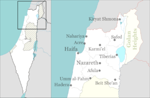
| Country |
| |
| District | Northern | |
| Founded |
1900 BCE (Canaanite settlement) 7th century (Samaritan town) 14th century (Arab village) 1925 (Jewish village) | |
| Government | ||
| • Type | City | |
| • Mayor | Yitzhak Meron | |
| Area | ||
| • Total | 26,909 dunams (26.909 km2 or 10.390 sq mi) | |
| Population (2017)[1] | ||
| • Total | 49,169 | |
| • Density | 1,800/km2 (4,700/sq mi) | |

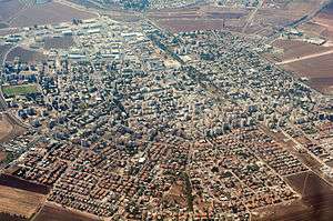
Afula (Hebrew: עֲפוּלָה, Arabic: العفولة) is a city in the Northern District of Israel, often known as the "Capital of the Valley" due to its strategic location in the Jezreel Valley. In 2017 the city had a population of 49,169.[1]
Etymology
Afula is mentioned first around 19th century BC as "Ofel" in the Execration texts.[2]
During the Ottoman era, in the 18th century, there was a small Arab village el-'Afuleh or Affule, in this region.[3] The modern name may be derived from the name of this village, possibly originating in the Canaanite-Hebrew root ofel ("fortress tower"),[4] or the Arab word for "ruptured".[5]
History
Copper Age to Middle Ages
Afula is possibly the place Ophlah, mentioned in the lists of Pharaoh Thutmose III.[6] Afula has been identified with the ancient Israelite town of Ofel mentioned in the Hebrew Bible.[7] With the destruction of the Kingdom of Israel, the area continued to be inhabited, and excavations have revealed artifacts from the periods of Persian and Roman rule. Conder suggested that Afula was identical with Kirjath Ophlathah, a place inhabited by Samaritans in the 7th century.[8]
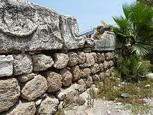
An ancient mound or tell known as Tel 'Afula, located in the heart of modern Afula, suggests almost continuous habitation from the late Chalcolithic period to the Ayyubid period in the 13th century. It contains the remains of a fortress from the Crusader and Mamluk periods. A fortified Crusader tower, 19 meters square, stands in the center. The lower four courses are made of rough boulders, while the top remaining layer is made of reused Roman sarcophagi. The wall is a total of 5.5 meters tall. Pottery remains indicate that it was occupied in the twelfth and thirteenth century.[9] For older finds from Tel 'Afula see the Archaeology paragraph.
In 1321, Afula was mentioned under the name of Afel by Marino Sanuto.[10]
Ottoman era
A map by Pierre Jacotin from Napoleon's invasion of 1799 showed this place, named as Afouleh in a French transliteration of the Arabic.[11]
In 1816, James Silk Buckingham passed by and described Affouli as being built on rising ground, and containing only a few dwellings. He noted several other nearby settlements in sight, all populated by Muslims.[12]
In 1838, Edward Robinson described both Afuleh and the adjacent El Fuleh as "deserted".[13] [14] William McClure Thomson, in a book published in 1859, noted that Afuleh and the adjacent El Fuleh, were "both now deserted, though both were inhabited twenty-five years ago when I first passed this way." Thomson blamed their desertion on the bedouin.[15]
In 1875 Victor Guérin described Afula as a village on a small hill overlooking a little plain. The houses were built of adobe and various other materials. Around the well, which Guérin thought was probably ancient, he noticed several tubs of broken sarcophagi serving as troughs.[16] In 1882, the Palestine Exploration Fund's Survey of Western Palestine described El Afuleh as a small adobe village in the plain, supplied by two wells.[6]
A population list from about 1887 showed that el Afuleh had about 630 inhabitants; all Muslims.[17] Gottlieb Schumacher, as part of surveying for the construction of the Jezreel Valley railway, noted in 1900 that it consisted of 50-55 huts and had 200 inhabitants. North of the village was a grain stop, belonging to the Sursocks.[18]
In 1909 or 1910, Yehoshua Hankin completed his first major purchase in the Jezreel Valley. He bought some 10,000 dunams (10 km²) of land in Al-Fuleh (now Afula), which became the home of two moshav settlements, Merhavia and Tel Adashim.[19]
First World War
During the First World War, Afulah was a major communications hub.
In 1917, when Colonel Richard Meinertzhagen of British intelligence established contact with the Nili Jewish spy network in Palestine, a German Jewish doctor stationed at el-Afulah railway junction provided the British with valuable reconnaissance reports on Ottoman and German troop movements southwards.
With the advance of General Edmund Allenby's British forces into Ottoman Palestine, el-Afulah was captured by the 4th Cavalry Division of the Desert Mounted Corps, during the cavalry phase of the Battle of Sharon in September 1918.
British Mandate era
According to the British Mandate's 1922 census of Palestine, Affuleh had 563 inhabitants; 471 Muslims, 62 Christians, 28 Jews and 2 Baha'i,[20] 61 of the Christians were Orthodox, while one was Melkite.[21]
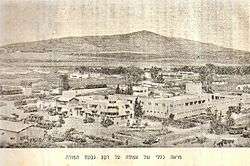
In 1925, modern Afula was founded after the American Zionist Commonwealth completed a purchase of the Afula valley from the Sursuk family of Beirut. A quarter of the one hundred Arab families who had lived in the area accepted compensation for their land and left voluntarily; the remainder were evicted.[19][22] Jews began settling in Afula shortly after as the town developed.
By the 1931 census, the population had increased to 874; with 786 Jews, 86 Muslims, 9 Christians, and 3 classified as "no religion", in a total of 236 houses.[23]
In the 1945 census the population of Afula was recorded as 2,300 Jews and 10 Muslims.[24] The town had a total of 18,277 dunams of land, according to an official land and population survey.[25] Of this, 145 dunams of land was used to cultivate citrus and bananas, 347 dunams were for plantations and irrigable land, 15,103 for cereals,[26] while 992 dunams were built-up land.[27]
During this time, the community was served by the Jezreel Valley Railway, part of the larger Hejaz Railway. Since 1913 it had also been the terminus station of the branch connecting it to Jenin and later also to Nablus. Sabotage actions of Jewish underground militias in 1945, 1946 and shortly before the 1948 Arab–Israeli War rendered first the connection to Jenin, then progressively the entire Valley Railway, inoperable.
1948, and after
Repairs to the Jezreel Valley Railway after 1948 restored service to Haifa, but only until 1949 when it was abandoned. In 2011 construction began on a large-scale project to build a new standard gauge railway from Haifa to Beit She'an with stations in Afula and other towns, along roughly the same route as the historic valley railway. Israel Railways began passenger service on the new railway on October 16, 2016.[28]
Due to Afula's proximity to the West Bank, it has been a target for Palestinian political violence.[29] On 6 April 1994, the Afula Bus suicide bombing killed five people in the center of Afula. In the Afula axe attack in November 1994, a 19-year-old female soldier was attacked and murdered by an axe-wielding Arab militant.[30] Afula also was the target of a suicide attack on a bus on 5 March 2002, in which one person died and several others were injured at Afula's central bus station. In the Afula mall bombing on 19 May 2003, a woman suicide bomber blew herself up at the Amakim mall, killing three and wounding 70. This attack was claimed by the Palestinian Islamic Jihad and the Fatah movement's Al-Aqsa Martyrs Brigades.
On 17 July 2006, during the Israel–Hezbollah War, Hezbollah fired Katyusha rockets at Afula, one of the southernmost rocket attacks on Israel from Lebanon. Six people were treated for shock as a result of the attack. On 28 July, a rocket landed causing a fire. The rocket carried 100 kilograms (220 pounds) of explosives.[31]
In September 2016, it was announced that seven new neighborhoods would be built, doubling the city's population.[32]
Economy
The Alon Tavor Industrial Zone is located northeast of Afula off Highway 65. The Tadiran air conditioner factory is located there.[33] Two Israeli plastics manufacturers, Keter Plastic and StarPlast, are also based there.[34]
Education and culture
According to CBS, there are 24 schools and 8,688 students in the city: 16 elementary schools with a student population of 3,814 and 12 high schools with 4,874 students. 52.3% of 12th grade students were entitled to a matriculation certificate in 2001.
Health care
HaEmek Medical Center in Afula was the first regional hospital in the country.[4]
Archaeology
The ancient mound of Afula, known as Tel 'Afula, is close to the city center, west of Route 60 and south of Ussishkin Street. Very little of the initial six-acre tell remains due to construction work done in this area since the British Mandate period. The southern peak of the mound is the better preserved part. It was once widely considered to be the biblical site of Ophrah, the hometown of the judge Gideon,[35] but contemporary scholars generally disagree with this supposition. Archaeological finds date from the Chalcolithic through the Byzantine period, followed by remains from the Crusader and Mamluk periods.
The first excavations at Tel ‘Afula, carried out in 1948, found Late Chalcolithic–Early Bronze Age remains. Tombs from the Early Bronze Age, Middle Bronze Age II, Late Bronze Age–Iron Age I and Roman period were discovered near the municipal water tower. Archaeologists discovered the Crusader-Mamluk fortress on the southern peak of the tell, a Byzantine olive press and evidence of an Early Bronze Age settlement near the northern peak.[36]
In 1950–1951, excavations on the northwestern slope of the peak revealed a pottery workshop for Tell el-Yahudiyeh Ware from Middle Bronze Age II and another pottery workshop from Middle Bronze Age I.[36]
From the 1990s, several small excavations unearthed an uninterrupted sequence of settlement remains from the Chalcolithic until the Late Byzantine periods as well as remains from the Mamluk period.[37]
In 2012, excavations were conducted by the Israel Antiquities Authority on the southern peak of Tel Afula where the Crusader-Mamluk fortress is located. Due to construction activity from the 1950s, settlement layers on the tell may have been destroyed. Only meager remnants were found, indicative of a settlement from Early Bronze Age I and the Roman period. Pottery from Early Bronze Age III, Iron Age I and a single Hellenistic Attic fragment indicate settlement on the tell in these periods. Fragments of glazed bowls from the thirteenth century were found along the southern edge of the excavation.[36]
Sports
The city's basketball club, Hapoel Afula, currently play in the Liga Leumit. The main football club, Hapoel Afula, won Liga Alef in the 2012-13 season and is currently playing at Liga Leumit.
Twin towns

Notable residents
- Amir Blumenfeld (born 1983), writer, comedian, actor, and television host
- Yaakov Bodo (born 1931), actor and comedian
- Sarit Hadad (born 1978), singer
- David Kushnir (born 1931), Olympic long-jumper
- Hila Lulu Linn, painter
- Samuel Scheimann (born 1987), football player
- Mosh Ben-Ari (born 1970), musician, lyricist and composer
- Nikol Reznikov (born 1999), model and Miss Universe Israel 2018.
References
- 1 2 "List of localities, in Alphabetical order" (PDF). Israel Central Bureau of Statistics. Retrieved August 26, 2018.
- ↑ Execration texts
- ↑
- 1 2 Afulah, Encyclopedia Judaica
- ↑ Palmer, 1881, p. 142
- 1 2 Conder and Kitchener, 1882, SWP II, p. 40
- ↑ http://www.govisitisrael.com/afula/113/
- ↑ Conder, 1876, p. 196
- ↑ Pringle, 1997, p. 18
- ↑ Conder and Kitchener, 1882, SWP II, p. 41
- ↑ Karmon, 1960, p. 167.
- ↑ Buckingham, 1822, vol 2, p. 381
- ↑ Robinson and Smith, 1841, vol 3, pp. 163, 181
- ↑ NB note that ruined villages were marked with a star in the village lists, however neither Afulah of Al Fuleh were marked with that, see: Robinson and Smith, 1841, vol 3, 2nd appendix, p. 132
- ↑ Thomson, 1859, vol 2, p. 216
- ↑ Guérin, 1880, pp. 109-110
- ↑ Schumacher, 1888, p. 183
- ↑ Schumacher, 1900, p. 358
- 1 2 Segev, 1999, p. 242
- ↑ Barron, 1923, Table XI, Sub-district of Nazareth, p. 38
- ↑ Barron, 1923, Table XVI, p. 50
- ↑ 130 families, according to List of villages sold by Sursocks and their partners to the Zionists since British occupation of Palestine, evidence to the Shaw Commission, 1930
- ↑ Mills, 1932, p. 73
- ↑ Government of Palestine, Department of Statistics, 1945, p. 8
- ↑ Government of Palestine, Department of Statistics. Village Statistics, April, 1945. Quoted in Hadawi, 970, p. 62
- ↑ Government of Palestine, Department of Statistics. Village Statistics, April, 1945. Quoted in Hadawi, 1970, p. 109
- ↑ Government of Palestine, Department of Statistics. Village Statistics, April, 1945. Quoted in Hadawi, 1970, p. 159
- ↑ Hilley, Yonathan (October 16, 2016). "The Wheels of History: Valley Railway Returns After 64 Years" [גלגלי ההיסטוריה: אחרי 64 שנים, רכבת העמק שבה לפעילות] (in Hebrew). Maariv. Retrieved October 16, 2016.
- ↑ "Five die in latest suicide bombing; British bomber dead"
- ↑ Arab Kills Female Israeli Soldier With Ax, The Washington Post, 1 December 1994
- ↑ Hezbollah missiles with 100 kg (220 lb) warhead strike Jezreel Valley
- ↑ http://hamodia.com/2016/09/14/afula-double-size/
- ↑ Company Overview of Tadiran Air Conditioners Ltd.
- ↑ Afula community guide
- ↑
- 1 2 3 Feig, 2012, Tel Afula final report
- ↑ Dalali-Amos, 2008, ‘Afula Final Report
Bibliography
- Barag, Dan (1979). "A new source concerning the ultimate borders of the Latin Kingdom of Jerusalem". Israel Exploration Journal. 29: 197–217.
- Bron, Hendrik (2013-08-28). "'Afula Final Report" (125). Hadashot Arkheologiyot – Excavations and Surveys in Israel.
- Buckingham, J.S. (1822). Travels in Palestine through the countries of Bashan and Gilead, east of the River Jordan, including a visit to the cities of Geraza and Gamala in the Decapolis. 2. London: Longman, Hurst, Rees, Orme and Brown.
- Conder, C.R. (1876). "Samaritan Topography". Quarterly statement - Palestine Exploration Fund. 22: 182–197.
- Conder, C.R.; Kitchener, H.H. (1882). The Survey of Western Palestine: Memoirs of the Topography, Orography, Hydrography, and Archaeology. 2. London: Committee of the Palestine Exploration Fund.
- Dalali-Amos, Edna (2008-12-17). "'Afula" (121). Hadashot Arkheologiyot – Excavations and Surveys in Israel.
- Dalali-Amos, Edna (2012-10-15). "'Afula" (124). Hadashot Arkheologiyot – Excavations and Surveys in Israel.
- Dalali-Amos, Edna (2014-02-16). "'Afula Final Report" (126). Hadashot Arkheologiyot – Excavations and Surveys in Israel.
- Dalali-Amos, Edna; Getzov, Nimrod (2014-08-31). "'Afula Preliminary Report" (126). Hadashot Arkheologiyot – Excavations and Surveys in Israel.
- Eisenberg, Michael (2006-12-14). "'Afula, Tel" (118). Hadashot Arkheologiyot – Excavations and Surveys in Israel.
- Feig, Nurit (2012-11-04). "'Afula, Tel Final Report" (124). Hadashot Arkheologiyot – Excavations and Surveys in Israel.
- Glass, Joseph B. (2002). From new Zion to old Zion : American Jewish immigration and settlement in Palestine, 1917 - 1939. Wayne State University Press.
- Government of Palestine, Department of Statistics (1945). Village Statistics, April, 1945.
- Guérin, V. (1880). Description Géographique Historique et Archéologique de la Palestine (in French). 3: Galilee, pt. 1. Paris: L'Imprimerie Nationale.
- Hadawi, S. (1970). Village Statistics of 1945: A Classification of Land and Area ownership in Palestine. Palestine Liberation Organization Research Center.
- Karmon, Y. (1960). "An Analysis of Jacotin's Map of Palestine" (PDF). Israel Exploration Journal. 10 (3, 4): 155–173, 244–253.
- Mills, E., ed. (1932). Census of Palestine 1931. Population of Villages, Towns and Administrative Areas. Jerusalem: Government of Palestine.
- Palmer, E.H. (1881). The Survey of Western Palestine: Arabic and English Name Lists Collected During the Survey by Lieutenants Conder and Kitchener, R. E. Transliterated and Explained by E.H. Palmer. Committee of the Palestine Exploration Fund.
- Pringle, Denys (1997). Secular buildings in the Crusader Kingdom of Jerusalem: an archaeological Gazetter. Cambridge University Press. ISBN 0521 46010 7.
- Robinson, E.; Smith, E. (1841). Biblical Researches in Palestine, Mount Sinai and Arabia Petraea: A Journal of Travels in the year 1838. 3. Boston: Crocker & Brewster.
- Schumacher, G. (1888). "Population list of the Liwa of Akka". Quarterly statement - Palestine Exploration Fund. 20: 169–191.
- Schumacher, G. (1900). "Reports from Galilee". Quarterly statement - Palestine Exploration Fund. 32: 355–360.
- Segev, T. (1999). One Palestine Complete: Jews and Arabs Under the British Mandate. London: Abacus. ISBN 978-0-349-11286-2.
- Thomson, W.M. (1859). The Land and the Book: Or, Biblical Illustrations Drawn from the Manners and Customs, the Scenes and Scenery, of the Holy Land. 2 (1 ed.). New York: Harper & brothers.
- Zevulun, U., "Tell el-Yahudiyeh Juglets from a Potter’s Refuse Pit at Afula", Eretz-Israel 21 (1990), pp. 174–190, p. 107.
External links
| Wikivoyage has a travel guide for Afula. |
- Afula municipal website
- Central Bureau of Statistics, Afula
- Survey of Western Palestine, Map 8: IAA, Wikimedia commons
- Afula municipal website on russian lang/