Fassuta
Fassouta
| |
|---|---|
| Hebrew transcription(s) | |
| • ISO 259 | P̄assúṭa |
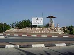 Entrance to Fassouta | |
 Fassouta  Fassouta | |
| Coordinates: 33°02′58″N 35°18′21″E / 33.04944°N 35.30583°ECoordinates: 33°02′58″N 35°18′21″E / 33.04944°N 35.30583°E | |
| Grid position | 179/272 PAL |
| District | Northern |
| Government | |
| • Type | Local council |
| Population (2017)[1] | |
| • Total | 3,098 |
| Name meaning | Fassute, personal name[2] |
Fassouta is an Arab local council on the northwestern slopes of Mount Meron in the Northern District of Israel, south of the Lebanese border.[3] In 2017 it had a population of 3,098.[1]
History
In the Crusader era Fassouta was known as Fassove, and in 1183 it was noted that Godfrey de Tor sold the land of the village to Joscelin III.[4] In 1220 Jocelyn III´s daughter Beatrix de Courtenay and her husband Otto von Botenlauben, Count of Henneberg, sold their land, including Fassove, to the Teutonic Knights.[5][6]
Ottoman era
Fassuta was incorporated into the Ottoman Empire in 1517, and by 1596 it was part of the Nahiya of Akka of the Liwa of Safad. It had a population of 12 Muslim households and 3 Muslim bachelors. It paid taxes on wheat, barley, fruit trees, and goats or beehives.[7]
In 1881, the Palestine Exploration Fund's Survey of Western Palestine (SWP) described Fassuta as "a village, built of stone, containing about 200 Christians, situated on ridge, with gardens of figs, olives, and arable land. There are two cisterns in the village, and a good spring near."[8]
A population list from about 1887 showed Fassutah to have about 570 inhabitants.[9]
British Mandate era
At the time of the 1922 census of Palestine conducted by the British Mandate, Fassuta had a population of 459, 444 Christians and 15 Muslims,[10] where the Christians were 1 Orthodox, 18 Syrian orthodox, and 425 Melkites.[11] In the 1931 census, the combined population of Fassuta and Mansura was 507 Palestinian Christians and 81 Muslims, living in a total of 129 houses.[12]
In the 1945 statistics Fassuta had 1,050 inhabitants.[13][14] The combined population of Fassuta, Al-Mansura and Dayr al-Qasi was 2,300, and their total land area was 34,011 dunums.[14][15] 1,607 dunams were plantations and irrigable land, 6,475 used for cereals,[16] while 247 dunams were built-up (urban) land.[17]
At the end of October 1948 the village was captured by the Israeli army during Operation Hiram. Most of the Muslim population fled or were expelled but many of the Christians remained. In December 1949 the IDF put forward a plan to expel the remaining population of Fassuta and five other villages in order to create a 5–10 km Arab-free zone along the Lebanon border. This plan was blocked by the Foreign Ministry which feared international reaction.[18] The Arab population remained under Martial Law until 1966.
Between 1922 and 1947, the population of Fassuta increased by 120%.[19]
Demographics
In 2005, the population of Fassuta was 2,900 residents, with an annual population growth rate of 0.9%. All of the inhabitants are Christians of the Melkite (Greek) Catholic Church.[20] In 2000, 60.5% of Fassuta high school students passed the Bagrut matriculation exam. In 2000, the mean income was NIS 3,748, compared to a national average of NIS 6,835.
Religion and culture
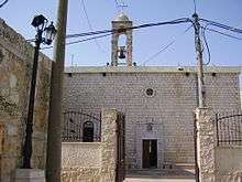
In 2007, the Mar Elias Church in Fassuta celebrated its 100th anniversary. The church is named after Elias, the village's patron saint. A large statue of Mar Elias stands in the central square.[3]
Archaeology
In 1875, Guerin found traces of ancient ruins: "Numerous cisterns, a great reservoir, vestiges of many ruined houses, fine cut stones marking out floors, and a dozen of presses nearly perfect. These presses are all on the same model : worked in the rock, they consisted of two compartments, one larger, in which the grapes were placed, and one smaller and lower down, in which the juice was received. In the humble church of the modern hamlet I remarked a chapter imitating Corinthian, and probably of Byzantine period. On two of its faces a cross with equal branches has been sculptured. Above the door of the main church has been placed for a lintel a fragment of frieze decorated with flowers and foliage elegantly executed."[21]
Notable residents
See also
References
- 1 2 "List of localities, in Alphabetical order" (PDF). Israel Central Bureau of Statistics. Retrieved August 26, 2018.
- ↑ Palmer, 1881, p. 72
- 1 2 Stern, Yoav (2007-04-30). "Galilee Villages Launch Campaign to Attract Christian Pilgrims". Haaretz. Retrieved 2008-10-25.
- ↑ Strehlke, 1869, pp. 15-16, No. 16; cited in Röhricht, 1893, RRH, p. 125, No. 624; cited in Frankel, 1988, pp. 257, 264
- ↑ Strehlke, 1869, pp. 43- 44, No. 53; cited in Röhricht, 1893, RRH, p. 248, No. 934; cited in Frankel, 1988, pp. 257, 264
- ↑ Marzorati, Gerald (1988-09-11). "An Arab Voice in Israel". The New York Times. Retrieved 2008-10-25.
- ↑ Hütteroth and Abdulfattah, 1977, p. 194
- ↑ Conder and Kitchener, 1881, SWP I, p. 197
- ↑ Schumacher, 1888, p. 191
- ↑ Barron, 1923, Table XI, Sub-district of Acre, p. 36
- ↑ Barron, 1923, Table XVI, p.50
- ↑ Mills, 1932, p. 100
- ↑ Department of Statistics, 1945, p. 4
- 1 2 Village Statistics April 1945, The Palestine Government Archived June 9, 2012, at the Wayback Machine., p. 2
- ↑ Government of Palestine, Department of Statistics. Village Statistics, April, 1945. Quoted in Hadawi, 1970, p. 40
- ↑ Government of Palestine, Department of Statistics. Village Statistics, April, 1945. Quoted in Hadawi, 1970, p. 80
- ↑ Government of Palestine, Department of Statistics. Village Statistics, April, 1945. Quoted in Hadawi, 1970, p. 130
- ↑ Morris, 1987, pp. 225, 242, 251
- ↑ Transformation in Arab Settlement, Moshe Brawer, in The Land that Became Israel: Studies in Historical Geography, Ruth Kark (ed), Magnes Press, Jerusalem 1989, p.177
- ↑ פסוטה 2014
- ↑ Guérin, 1880, p. 67, as translated by Conder and Kitchener, 1881, SWP I, p. 222
- ↑ El-Asmar, Fouzi (1975). To Be an Arab in Israel. London: Frances Pinter. pp. 177–8. ISBN 0-903804-08-5.
- ↑ "Anton Shammas". Khalil Sakakini Cultural Center. Archived from the original on 2008-06-07. Retrieved 2008-10-25.
Bibliography
- Abu-‘Uqsa, Hanaa Abu-‘Uqsa (2013-12-12). "Fassuta, Survey Final Report" (125). Hadashot Arkheologiyot – Excavations and Surveys in Israel.
- Barron, J. B., ed. (1923). Palestine: Report and General Abstracts of the Census of 1922. Government of Palestine.
- Bron, Hendrik (Enno) (2007-04-22). "Fassuta Final Report" (119). Hadashot Arkheologiyot – Excavations and Surveys in Israel.
- Bron, Hendrik (Enno) (2010-05-18). "Fassuta Preliminary Report" (122). Hadashot Arkheologiyot – Excavations and Surveys in Israel.
- Conder, C.R.; Kitchener, H.H. (1881). The Survey of Western Palestine: Memoirs of the Topography, Orography, Hydrography, and Archaeology. 1. London: Committee of the Palestine Exploration Fund.
- Dauphin, Claudine (1998). La Palestine byzantine, Peuplement et Populations. BAR International Series 726 (in French). III : Catalogue. Oxford: Archeopress. ISBN 0-860549-05-4. (p. 633 )
- Department of Statistics (1945). Village Statistics, April, 1945. Government of Palestine.
- Frankel, Rafael (1988). "Topographical notes on the territory of Acre in the Crusader period". Israel Exploration Journal. 38 (4): 249–272.
- Guérin, V. (1880). Description Géographique Historique et Archéologique de la Palestine (in French). 3: Galilee, pt. 2. Paris: L'Imprimerie Nationale.
- Hadawi, S. (1970). Village Statistics of 1945: A Classification of Land and Area ownership in Palestine. Palestine Liberation Organization Research Center.
- Hütteroth, Wolf-Dieter; Abdulfattah, Kamal (1977). Historical Geography of Palestine, Transjordan and Southern Syria in the Late 16th Century. Erlanger Geographische Arbeiten, Sonderband 5. Erlangen, Germany: Vorstand der Fränkischen Geographischen Gesellschaft. ISBN 3-920405-41-2.
- Mills, E., ed. (1932). Census of Palestine 1931. Population of Villages, Towns and Administrative Areas. Jerusalem: Government of Palestine.
- Morris, B. (1987). The Birth of the Palestinian Refugee Problem. Cambridge University Press. ISBN 0-521-33028-9.
- Palmer, E.H. (1881). The Survey of Western Palestine: Arabic and English Name Lists Collected During the Survey by Lieutenants Conder and Kitchener, R. E. Transliterated and Explained by E.H. Palmer. Committee of the Palestine Exploration Fund.
- Röhricht, R. (1893). (RRH) Regesta regni Hierosolymitani (MXCVII-MCCXCI) (in Latin). Berlin: Libraria Academica Wageriana.
- Schumacher, G. (1888). "Population list of the Liwa of Akka". Quarterly statement - Palestine Exploration Fund. 20: 169–191.
- Strehlke, Ernst, ed. (1869). Tabulae Ordinis Theutonici ex tabularii regii Berolinensis codice potissimum. Berlin: Weidmanns.
- Tahan, Hagit (2008-12-30). "Fassuta Final Report" (121). Hadashot Arkheologiyot – Excavations and Surveys in Israel.
External links
- Welcome To Fassuta
- Survey of Western Palestine, Map 4: IAA, Wikimedia commons