Iksal
Iksal
| |
|---|---|
| Hebrew transcription(s) | |
| • ISO 259 | ʔikksal, Ksalot Tabor |
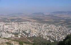 Iksal, as seen from Nazareth Illit | |
 Iksal | |
| Coordinates: 32°41′N 35°19′E / 32.683°N 35.317°ECoordinates: 32°41′N 35°19′E / 32.683°N 35.317°E | |
| Grid position | 180/232 PAL |
| District | Northern |
| Government | |
| • Type | Local council |
| Area | |
| • Total | 9,000 dunams (9 km2 or 3 sq mi) |
| Population (2017)[1] | |
| • Total | 14,245 |
| • Density | 1,600/km2 (4,100/sq mi) |
| Name meaning | from Iksal, personal name[2] |
| Website |
موقع إكسال مدرسة إكسال الثانوية مدرسة إكسال الإعدادية |
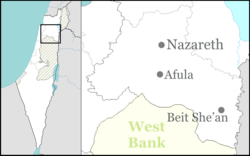
Iksal (Arabic: إكسال, Iksal; Hebrew: אִכְּסָאל, כִּסְלוֹת תָּבוֹר, Kislot Tavor[3]) is an Arab local council in northern Israel, about 5 kilometres (3.1 mi) southeast of Nazareth.[4] It has an area of 9,000 dunams and a population of 14,245 primarily Muslim inhabitants.[1]
Name
The name of town is believed to derive from that of Chesulloth (Chisloth-Tabor), a biblical town mentioned in the Book of Joshua (Joshua 19:12).[4][5]
History
Iksal was known to Josephus as Xaloth.[6][7] Archaeological excavations in Iksal revealed artifacts from the period of Roman and Byzantine rule in Palestine.[8] A ring decorated with the image of a lion was found and dates to one of these time periods.[9] In burial caves carved into the rock, sarcophagi and ossuaries containing pottery, glass vessels, and jewelry were found. Also dated to the Byzantine period are agricultural installations, carved into the rock and plastered, inside of which were found part of a winepress.[8]
In 536 a Council was held in Jerusalem to condemn Severus of Antioch and his followers. Present at that Council were 45 bishops from Palestine, including one Parthenius, bishop of Exalus, which is identified with Iksal.[10] Thus we know the town had enough Christians in the 6th Century to warrant a bishop.
On December 22, 946, the forces of the Egyptian Ikhshidid dynasty defeated those of Sayf al-Daula at Iksal. The latter retreated to Aleppo, while the Ikshidid forces advanced onto Damascus.[11]
During the period of Crusader or Mamluk rule in Palestine, a castle was built in Iksal, the ruins of which remain visible today.[8] The Crusaders probably added to a much older structure which had been constructed first in the Abbasid, and then in the Fatimid era.[12] A large cemetery by the village was named Mukbarat el Afranj ("Cemetery of the Franks").[13]
Yaqut al-Hamawi († 1229) described the place (which he called Aksal), as "A village in the Jordan Province, lying 5 leagues from Tiberias towards Ar Ramlah. The river Abu Futrus is in the neighbourhood."[14]
Building remains from the Mamluk period have also been excavated.[8] One excavation revealed three constructions with pottery remains, all dating from the Mamluk era, 14th and 15th century CE.[15]
Ottoman period
In 1517, the village was included in the Ottoman empire with the rest of Palestine, and in the 1596 tax-records it appeared as Ksal, located in the Nahiya of Tabariyya of the Safad Sanjak. The population was 17 households and 1 bachelor, all Muslim. They paid a tax rate of 25% on agricultural products, which included wheat, barley, summer crops, fruit trees, occasional revenues, goats and beehives; a total of 6,633 Akçe.[16][17]
In 1738 Richard Pococke passed by the place, which he called Zal. He noted that near it was "many sepulchres cut in the rock, some of them are like stone coffins above-ground, others are cut into the rock, like graves, some of them have stone covers over them, so that formerly this might be no inconsiderable place."[18] A map from Napoleon's invasion of 1799 by Pierre Jacotin showed the place, named as Iksad.[19]
Edward Robinson, who passed by the village in 1838, repeated Pocockes assertion that Iksal had many sepulchres.[20]
In 1863 Henry Baker Tristram saw the remains of a "Crusader" tower in Iksal,[21] while in 1875, Victor Guérin found it to have 400 inhabitants, all Muslim.[22] In 1881, the Palestine Exploration Fund's Survey of Western Palestine (SWP) described Iksal as "a large stone village, built in the plains, with a conspicuous square tower, surrounded by gardens and containing about 400 Moslims, many caves and cisterns."[23]
A population list from about 1887 showed that Iksal had about 600 Muslim inhabitants.[24]
British Mandate era
At the time of the 1922 census of Palestine Iksal had a population of 621 Muslims,[25] increasing slightly in the 1931 census to 752, still all Muslims, in a total of 166 houses.[26]
In the 1945 statistics the population was 1,110, all Muslims,[27] while the total land area was 16,009 dunams, according to an official land and population survey.[28] Of this, 581 were allocated for plantations and irrigable land, 13,029 for cereals,[29] while 47 dunams were classified as built-up areas.[30]
1948 war and aftermath
Like many other Arab towns and villages in the Galilee that were left standing after the 1948 Arab-Israeli War, Iksal surrendered to Israeli forces without putting up a fight. Individuals who had collaborated with Zionist officials prior to Israel's establishment, negotiated the terms of surrender and transition to rule under the new military government.[31]
Demographics
According to the Israel Central Bureau of Statistics, the town had a low ranking (3 out of 10) on the country's socioeconomic index (December 2001). Only 65.3% of students are entitled to a matriculation certificate after Grade 12 (2000). The average salary that year was NIS 3,640 per month, whereas the national average was NIS 6,835. Its population has grown at an annual rate of 2.8%. In Iksal, about 60 percent of the inhabitants are family relations of one another.[32]
See also
References
- 1 2 "List of localities, in Alphabetical order" (PDF). Israel Central Bureau of Statistics. Retrieved August 26, 2018.
- ↑ Palmer, 1881, p. 126
- ↑ HaReuveni, Immanuel (1999). Lexicon of the Land of Israel (in Hebrew). Miskal - Yedioth Ahronoth Books and Chemed Books. p. 37. ISBN 965-448-413-7.
- 1 2 Freedman et al, 2000, p. 236.
- ↑ Aharoni, 1979, pp. 120, 257.
- ↑ Armstrong, 2009, p. 42.
- ↑ Conder and Kitchener, 1881, SWP I, p. 366
- 1 2 3 4 Alexandre, 2008, Iksal, Final Report
- ↑ Chancey, 2005, p. 216.
- ↑ Bagatti, 2001, p. 217
- ↑ Gil, 1997, pp. 319-320
- ↑ Sharon, 2013, p. 302
- ↑ Conder and Kitchener, 1881, SWP I, p. 385 ff
- ↑ le Strange, 1890, pp. 390-1
- ↑ Mokary, 2011, Iksal, Final report
- ↑ Hütteroth and Abdulfattah, 1977, p. 187
- ↑ Note that Rhode, 1979, p. 6 writes that the register that Hütteroth and Abdulfattah studied from the Safad-district was not from 1595/6, but from 1548/9
- ↑ Pococke, 1745, vol II, p. 65
- ↑ Karmon, 1960, p. 167.
- ↑ Robinson and Smith, 1841, vol 3, p. 182
- ↑ Trisdam, 1865, p. 124
- ↑ Guérin, 1880, pp. 108-109
- ↑ Conder and Kitchener, 1881, SWP I, p. 363
- ↑ Schumacher, 1888, p. 184
- ↑ Barron, 1923, Table XI, Sub-district of Nazareth, p. 38
- ↑ Mills, 1932, p. 73
- ↑ Department of Statistics, 1945, p. 8
- ↑ Government of Palestine, Department of Statistics. Village Statistics, April, 1945. Quoted in Hadawi, 1970, p. 62
- ↑ Government of Palestine, Department of Statistics. Village Statistics, April, 1945. Quoted in Hadawi, 1970, p. 109
- ↑ Government of Palestine, Department of Statistics. Village Statistics, April, 1945. Quoted in Hadawi, 1970, p. 159
- ↑ Cohen, 2010, p.17
- ↑ Cushner, 2004, p.86
Bibliography
- Aharoni, Yohanan (1979). The land of the Bible: a historical geography (2nd, illustrated, revised ed.). Westminster John Knox Press. ISBN 0-664-24266-9.
- Alexandre, Yardenna (2008-03-26). "Iksal Final Report" (120). Hadashot Arkheologiyot – Excavations and Surveys in Israel.
- Alexandre, Yardenna (2011-08-29). "Iksal Final Report" (123). Hadashot Arkheologiyot – Excavations and Surveys in Israel.
- Armstrong, George (2009). Names and Places in the Old Testament and Apocrypha. BiblioBazaar, LLC. ISBN 1-103-29324-9.
- Bagatti, B. (2001). Ancient Christian Villages of Galilee. Jerusalem: Franiscan press.
- Barron, J.B., ed. (1923). Palestine: Report and General Abstracts of the Census of 1922. Government of Palestine.
- Chancey, Mark A. (2005). Greco-Roman culture and the Galilee of Jesus (Illustrated ed.). Cambridge University Press. ISBN 0-521-84647-1.
- Conder, C.R.; Kitchener, H.H. (1881). The Survey of Western Palestine: Memoirs of the Topography, Orography, Hydrography, and Archaeology. 1. London: Committee of the Palestine Exploration Fund.
- Cohen, H. (2010). Good Arabs: The Israeli Security Agencies and the Israeli Arabs, 1948-1967. University of California Press. ISBN 0-520-25767-7.
- Cushner, Kenneth (2004). Beyond tourism: a practical guide to meaningful educational travel. Rowman & Littlefield. ISBN 1-57886-154-3.
- Dauphin, Claudine (1998). La Palestine byzantine, Peuplement et Populations. BAR International Series 726 (in French). III : Catalogue. Oxford: Archeopress. ISBN 0-860549-05-4.
- Department of Statistics (1945). Village Statistics, April, 1945. Government of Palestine.
- Freedman, D.N.; Myers, Allen C.; Beck, Astrid B. (2000). Eerdmans dictionary of the Bible (Illustrated ed.). Wm. B. Eerdmans Publishing. ISBN 0-8028-2400-5.
- Gil, M. (1997). A history of Palestine, 634-1099. Cambridge University Press. ISBN 0-521-59984-9.
- Guérin, V. (1880). Description Géographique Historique et Archéologique de la Palestine (in French). 3: Galilee, pt. 1. Paris: L'Imprimerie Nationale.
- Hadawi, S. (1970). Village Statistics of 1945: A Classification of Land and Area ownership in Palestine. Palestine Liberation Organization Research Center.
- Hütteroth, Wolf-Dieter; Abdulfattah, Kamal (1977). Historical Geography of Palestine, Transjordan and Southern Syria in the Late 16th Century. Erlanger Geographische Arbeiten, Sonderband 5. Erlangen, Germany: Vorstand der Fränkischen Geographischen Gesellschaft. ISBN 3-920405-41-2.
- Karmon, Y. (1960). "An Analysis of Jacotin's Map of Palestine" (PDF). Israel Exploration Journal. 10 (3, 4): 155–173, 244–253.
- Mills, E., ed. (1932). Census of Palestine 1931. Population of Villages, Towns and Administrative Areas. Jerusalem: Government of Palestine.
- Mokary, Abdalla (2011-06-23). "Iksal Final Report" (123). Hadashot Arkheologiyot – Excavations and Surveys in Israel.
- Palmer, E.H. (1881). The Survey of Western Palestine: Arabic and English Name Lists Collected During the Survey by Lieutenants Conder and Kitchener, R. E. Transliterated and Explained by E.H. Palmer. Committee of the Palestine Exploration Fund.
- Pococke, R. (1745). A description of the East, and some other countries. 2. London: Printed for the author, by W. Bowyer.
- Rhode, H. (1979). Administration and Population of the Sancak of Safed in the Sixteenth Century. Columbia University.
- Robinson, E.; Smith, E. (1841). Biblical Researches in Palestine, Mount Sinai and Arabia Petraea: A Journal of Travels in the year 1838. 3. Boston: Crocker & Brewster.
- Schumacher, G. (1888). "Population list of the Liwa of Akka". Quarterly statement - Palestine Exploration Fund. 20: 169–191.
- Sharon, M. (2013). Corpus Inscriptionum Arabicarum Palaestinae, H-I. 5. BRILL. ISBN 90-04-25097-2.
- Strange, le, G. (1890). Palestine Under the Moslems: A Description of Syria and the Holy Land from A.D. 650 to 1500. Committee of the Palestine Exploration Fund.
- Tristram, H.B. (1865). Land of Israel, A Journal of travel in Palestine, undertaken with special reference to its physical character. London: Society for Promoting Christian Knowledge.
External links
- Welcome To Iksal
- Survey of Western Palestine, Map 6: IAA, Wikimedia commons