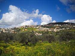
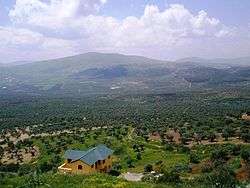
Maghar, Israel
Maghar
| ||
|---|---|---|
| Hebrew transcription(s) | ||
| • ISO 259 | (Mrar) (Israeli pronunciation) | |
| • Also spelled |
Mughar (official) Mrar, Mghar (unofficial) | |
 | ||
| ||
 Maghar | ||
| Coordinates: 32°53′24″N 35°24′30″E / 32.89000°N 35.40833°ECoordinates: 32°53′24″N 35°24′30″E / 32.89000°N 35.40833°E | ||
| Grid position | 188/255 PAL | |
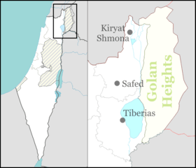
| District | Northern | |
| Government | ||
| • Type | Local council (from 1956) | |
| Area | ||
| • Total | 27,364 dunams (27.364 km2 or 10.565 sq mi) | |
| Population (2017)[1] | ||
| • Total | 22,261 | |
| • Density | 810/km2 (2,100/sq mi) | |
| Name meaning | The Caves[2] | |
Maghar (Arabic: المغار, Hebrew: מַעָ'אר, also al-Maghar or Mghar; lit. the cave) is an Druze/Arab town in Israel's Northern District with an area of 19,810 dunams. Maghar was given the status of a local council in 1956. In 2017 it had a population of 22,261.[1]
History
Antiquity
Pottery remains from the early Roman period have been found here, together with architectural remains and pottery fragments from the Late Roman period.[3] A quarry has also been excavated.[4]
The village's name comes from the Arabic word for "the caves".[2]
Ottoman era
The village was incorporated into the Ottoman Empire in 1517 with all of Palestine, and in 1555 a tax was paid on silk spinning.[5] In 1596 the village appeared in the tax registers as Magar Hazur, located in the nahiya of Tabariyya, part of Sanjak Safad with an entirely Muslim population consisting of 169 households and 17 bachelors. The villagers paid a fixed tax rate of 25% on various agricultural products, including wheat, barley, olive trees, goats and/or beehives, in addition on a press for olives or grapes, a total of 14,136 akçe.[6][7]
In 1838, el Mughar was noted as a Christian and Druze village in the Esh-Shagur district, located between Safad, Acca and Tiberias.[8][9]
In 1875 Victor Guérin found the village, which he called el-Mehar, to be a large one with 1200 inhabitants. It was divided into three quarters, with Muslim, Christian and Druse inhabitants.[10] In 1881, the Palestine Exploration Fund's Survey of Western Palestine described El Mughar as a "large stone-built village, containing about 1,100 Moslems, Druses, and Christians, situated on the slope of the hill, with extensive olive-groves to the south and west; a large spring and birkeh gives a good supply of water."[11]
A population list from about 1887 showed El Mughar el Hazzur to have about 1,360 inhabitants; 180 Muslims, 625 Druze and 420 Catholic Christians.[12]
British Mandate
In the 1922 census of Palestine, conducted by the British Mandate authorities, Mughar wa Mansura had a total population of 1377. Of these, 265 were Muslim, 676 Druze and 436 Christians.[13] All the Christians were Roman Catholic.[14] In the 1931 census the population of Maghar, together with Al-Mansura, was a total of 1733, in 373 inhabited houses. Of these, 307 were Muslim, 549 Christians, and 877 Druze.[15]
In the 1945 statistics the population of Maghar, together with Al-Mansura, was 2,140;[16] 90 Muslims, 800 Christians and 1,250 others.[17] who owned 55,583 dunams of land according to an official land and population survey.[16] 7,864 dunams were plantations and irrigable land, 18,352 for cereals,[18] while 55 dunams were built-up (urban) land.[19]
State of Israel
During Operation Hiram, 29–31 October 1948, the town surrendered to the advancing Israeli army. Many of the inhabitants fled north but some stayed and were not expelled by the Israeli soldiers.[20] The town remained under Martial Law until 1966.
During the 2006 Israel-Lebanon conflict, two residents of Maghar were killed and several wounded in Hezbollah rocket and cluster bomb attacks.[21][22] On July 25, Doua Abbas, 15, was killed by a rocket that hit her house. On August 4, Manal Azzam, a 27-year-old mother of two, was killed, and two other residents were seriously wounded when a rocket hit their apartment building.[23][24]
Demographics
The majority of residents are Druze (57%), with Arab Christians (23%) and Muslims (20%).[25] Many of the Druze residents serve in the IDF and Israel Police.[26]
Education and culture
In August 2003, the Israel Circus School established a joint Jewish-Arab "Children’s Circus" together with its partner, Circus Maghar. A group of 20 Jewish and Arab children trained for the circus. In addition to local performances, the circus school toured Cyprus, giving workshops and performances for Christian and Muslim schools and community centers.[27]
Notable residents
- Naim Araidi, a Druze resident of Maghar, a professor of Hebrew literature at Haifa University and Bar Ilan University, was appointed Israel's ambassador to Norway in 2012.[28]
- Ihab Khatib, soldier
- Salman Masalha, poet, writer, essayist and translator
- Suliman Bashear, was a leading Druze Arab scholar and professor, who taught at Birzeit University, An-Najah National University, and the Hebrew University of Jerusalem. Bashear was noted for his work on the early historiography of Islam.
- Daud Turki, a Palestinian-Arab poet and the leader of the Jewish-Arab socialist group called the Red Front.
See also
References
- 1 2 "List of localities, in Alphabetical order" (PDF). Israel Central Bureau of Statistics. Retrieved August 26, 2018.
- 1 2 Palmer, 1881, p. 131
- ↑ Jaffe, 2010, Maghar
- ↑ Jaffe, 2011, Maghar
- ↑ Rhode, 1979, p. 145
- ↑ Hütteroth and Abdulfattah, 1977, p. 187.
- ↑ Note that Rhode, 1979, p. 6 writes that the Safad register that Hütteroth and Abdulfattah studied was not from 1595/6, but from 1548/9
- ↑ Robinson and Smith, 1841, vol. 3, 2nd appendix, p. 133
- ↑ Robinson and Smith, 1841, vol. 3, p. 239
- ↑ Guérin, 1880, pp. 457-458
- ↑ Conder and Kitchener, 1881, p. 364
- ↑ Schumacher, 1888, p. 174
- ↑ Barron, 1923, Table XI, Sub-district of Tiberias, p. 39
- ↑ Barron, 1923, Table XVI, p. 51
- ↑ Mills, 1932, p. 83
- 1 2 Government of Palestine, Department of Statistics. Village Statistics, April, 1945. Quoted in Hadawi, 1970, p. 72
- ↑ Government of Palestine, Department of Statistics, 1945, p. 12
- ↑ Government of Palestine, Department of Statistics. Village Statistics, April, 1945. Quoted in Hadawi, 1970, p. 122
- ↑ Government of Palestine, Department of Statistics. Village Statistics, April, 1945. Quoted in Hadawi, 1970, p. 172
- ↑ Morris, 1987, p. 226
- ↑ Kalman, Matthew (2006-08-05). "In Israel: Arabs are among the dead and wounded in Hezbollah rocket attacks". Casualties of War: Families. San Francisco Chronicle. Retrieved 2008-05-16.
- ↑ "Lebanon/Israel: Hezbollah Hit Israel with Cluster Munitions During Conflict". Human Rights Watch. Retrieved 2008-05-16.
- ↑ Arabs are among the dead and wounded in Hezbollah rocket attacks
- ↑ Einav, Hagai (2006-08-04). "3 killed in rocket attacks on north". Ynetnews. Retrieved 2008-05-16.
- ↑ Gutterman, Dov. Mughar (Israel) CRW Flags.
- ↑ Druze Christian Clashes Cool off in Maghar
- ↑ Israel Circus School and Circus Maghar
- ↑ Integration at Israel's embassy in Norway
Bibliography
- Barron, J.B., ed. (1923). Palestine: Report and General Abstracts of the Census of 1922. Government of Palestine.
- Braun, Eliot (2004-06-09). "Maghar Archive Report- Final Report" (116). Hadashot Arkheologiyot – Excavations and Surveys in Israel.
- Conder, C.R.; Kitchener, H.H. (1881). The Survey of Western Palestine: Memoirs of the Topography, Orography, Hydrography, and Archaeology. 1. London: Committee of the Palestine Exploration Fund.
- Government of Palestine, Department of Statistics (1945). Village Statistics, April, 1945.
- Guérin, Victor (1880). Description Géographique Historique et Archéologique de la Palestine (in French). 3: Galilee, pt. 1. Paris: L'Imprimerie Nationale.
- Hadawi, S. (1970). Village Statistics of 1945: A Classification of Land and Area ownership in Palestine. Palestine Liberation Organization Research Center.
- Hütteroth, Wolf-Dieter; Abdulfattah, Kamal (1977). Historical Geography of Palestine, Transjordan and Southern Syria in the Late 16th Century. Erlanger Geographische Arbeiten, Sonderband 5. Erlangen, Germany: Vorstand der Fränkischen Geographischen Gesellschaft. ISBN 3-920405-41-2.
- Jaffe, Gilad Bezal’el (2010-02-28). "Maghar Final Report" (122). Hadashot Arkheologiyot – Excavations and Surveys in Israel.
- Jaffe, Gilad Bezal’el (2011-10-09). "Maghar Final Report" (123). Hadashot Arkheologiyot – Excavations and Surveys in Israel.
- Mills, E., ed. (1932). Census of Palestine 1931. Population of Villages, Towns and Administrative Areas. Jerusalem: Government of Palestine.
- Morris, B. (1987). The Birth of the Palestinian Refugee Problem. Cambridge University Press. ISBN 0-521-33028-9.
- Palmer, E.H. (1881). The Survey of Western Palestine: Arabic and English Name Lists Collected During the Survey by Lieutenants Conder and Kitchener, R. E. Transliterated and Explained by E.H. Palmer. Committee of the Palestine Exploration Fund.
- Rhode, H. (1979). Administration and Population of the Sancak of Safed in the Sixteenth Century (PhD). Columbia University.
- Robinson, E.; Smith, E. (1841). Biblical Researches in Palestine, Mount Sinai and Arabia Petraea: A Journal of Travels in the year 1838. 3. Boston: Crocker & Brewster.
- Schumacher, G. (1888). "Population list of the Liwa of Akka". Quarterly statement - Palestine Exploration Fund. 20: 169–191.
External links
- Welcome To Maghar
- Survey of Western Palestine, Map 6: IAA, Wikimedia commons