Beit Jann
Beit Jann
| |
|---|---|
| Hebrew transcription(s) | |
| • ISO 259 | Beit Ǧann |
| • Also spelled | Beit Jann (unofficial) |
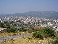 Beit Jann cityscape | |
 Beit Jann | |
| Coordinates: 32°57′55″N 35°22′46″E / 32.96528°N 35.37944°ECoordinates: 32°57′55″N 35°22′46″E / 32.96528°N 35.37944°E | |
| Grid position | 185/263 PAL |
| District | Northern |
| Founded | 13th or 14th century (as Druze settlement) |
| Government | |
| • Type | Local council |
| Area | |
| • Total | 4,650 dunams (4.65 km2 or 1.80 sq mi) |
| Population (2017)[1] | |
| • Total | 11,714 |
| • Density | 2,500/km2 (6,500/sq mi) |
| Name meaning | "The house of the genie", or "The garden house"[2] |
Beit Jann (Arabic: بيت جن; Hebrew: בֵּיתּ גַ'ן) is a Druze village on Mount Meron in northern Israel.[3] At 940 meters above sea level, Beit Jann is one of the highest inhabited locations in the country. In 2017 it had a population of 11,714.[1]
History
Beit Jann is an ancient village site at the top of a hill. Old stones have been reused in village homes, and cisterns and tombs carved into rock have also been found.[4]
In the Crusader era it was known as Beitegen.[5] In 1249, John Aleman transferred land, including the Casales of Beit Jann, Sajur, Majd al-Krum and Nahf to the Teutonic Knights.[6]
According to local legend, Druze families in the area lived in scattered colonies in the hills near sources of water until the 13th or 14th century. Two hunters looking for hyraxes stumbled upon a cave where they found an ancient cistern filled with water. Concluding that this was a good place for permanent settlement, several families settled on the site of what would become Beit Jann.[7]
Ottoman era
In 1517, the village was incorporated into the Ottoman Empire with the rest of Palestine, and in 1596, Bayt Jinn appeared in Ottoman tax registers as being in nahiya (subdistrict) of Akka under the liwa' (district) of Safad. It had a population of 102 households and 5 bachelors, all Muslims. They paid taxes on silk spinning (dulab harir),[8] occasional revenues, goats and/or beehives, olive oil press and/or a press for grape syrup.[9][10]
In August 1754, the missionary Stephan Schulz[11] visited the village. He noted that the inhabitants produced water-skins, and described the grapes of the region as particularly large and fine.[12][13]
The American biblical scholar Edward Robinson described Beit Jann as a "large well-built village" in 1852, with houses made of limestone. There were 260 males, all Druze, in the village.[13] In 1875, the French explorer Victor Guérin visited the village, which he called Beit Djenn. He estimated it had two hundred people, all Druze. He further noted that "A few years ago it was much larger, as is indicated by the abandoned houses which are beginning to fall into ruins. I am told that their occupants have fled to the Hauran to escape conscription.".. "The flanks of the hill on which the village stands are covered with vines which creep along the ground; their grapes [are] of a prodigious size.."[14] In 1881 the Palestine Exploration Fund's Survey of Western Palestine described Beit Jenn as a good village built of stone, with 300 Muslims and 100 Druze, with extensive gardens and vineyards.[15]
A population list from about 1887 showed Beit Jenn to have about 1,215 inhabitants; all Druse.[16]
British Mandate era
In the 1922 census of Palestine conducted by the British Mandate authorities, Bait Jan had a population of 902: 6 Muslims, 1 Christian and 895 Druze;[17] the only Christian was an Anglican.[18] At the time of the 1931 census, Beit Jann had 229 occupied houses and a population of 1100 Druze and 1 Muslim.[19]
In the 1945 statistics the population of Beit Jann together with Ein al-Asad was 1,640, all classified as "others" (=Druze),[20] who owned 43,550 dunams of land according to an official land and population survey.[21] 2,530 dunams were plantations and irrigable land, 7,406 used for cereals,[22] while 67 dunams were built-up (urban) land.[23]
Israel era
In September 1991, the body of Samir Assad, an Israel Defense Forces soldier from Beit Jann, held since 1983 by the DFLP, was returned in exchange for the return to Israel of exiled members of the DFLP.[24]
In July 2006, during the Second Lebanon War, Beit Jann was hit by Katyusha rockets fired by Hezbollah.[25] Illegal logging in the vicinity Beit Jann has led to conflicts with park officials and rangers.[26]
Geography and climate
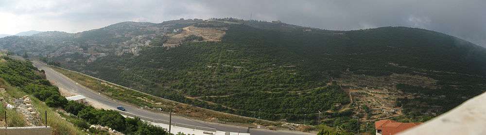
Beit Jann has a cool climate, even in summer, and offers panoramic views that stretch as far as the Sea of Galilee and the Mediterranean on a clear day. Several families in the village run bed and breakfast facilities.[27] The village is located inside the Mount Meron nature reserve.
Education
In 2013, Beit Jann high school was ranked first in the country for the number of students graduating with a bagrut matriculation certificate.[28]
See also
References
- 1 2 "List of localities, in Alphabetical order" (PDF). Israel Central Bureau of Statistics. Retrieved August 26, 2018.
- ↑ Palmer, 1881, p. 68
- ↑ Higher education in the Druze community
- ↑ Dauphin, 1998, p. 657
- ↑ Conder and Kitchener 1881, SWP I, p. 206
- ↑ Strehlke, 1869, pp. 78-79, No. 100; cited in Röhricht, 1893, RHH, p. 308, No. 1175; cited in Frankel, 1988, p. 254
- ↑ Mountain People, Jerusalem Post
- ↑ Rhode, 1979, See p. 145 for the silk tax, and p. 5 for the date.
- ↑ Hütteroth and Abdulfattah, 1977, p. 192
- ↑ Note that Rhode, 1979, p. 6 writes that the register that Hütteroth and Abdulfattah studied from the Safad-district was not from 1595/6, but from 1548/9
- ↑ Robinson and Smith, 1841, vol 3, Appendix, p. 21
- ↑ Schulz (ed. Paulus), 1803, p. 106
- 1 2 Robinson and Smith, 1856, p. 76
- ↑ Guérin, 1880, pp. 82-83, partly as translated in Conder and Kitchener, 1881, SWP I, p. 196
- ↑ Conder and Kitchener, 1881, SWP I, p. 196.
- ↑ Schumacher, 1888, p. 191
- ↑ Barron, 1923, Table XI, Sub-district of Acre, p. 36
- ↑ Barron, 1923, Table XVI, p. 50
- ↑ Mills, 1932, p. 100
- ↑ Department of Statistics, 1945, p. 4
- ↑ Government of Palestine, Department of Statistics. Village Statistics, April, 1945. Quoted in Hadawi, 1970, p. 40
- ↑ Government of Palestine, Department of Statistics. Village Statistics, April, 1945. Quoted in Hadawi, 1970, p. 80
- ↑ Government of Palestine, Department of Statistics. Village Statistics, April, 1945. Quoted in Hadawi, 1970, p. 130
- ↑ Prisoners-of-War and Captive Soldiers Exchanges
- ↑ Woman, grandson killed in Meron rocket attack Archived July 25, 2008, at the Wayback Machine. Ynetnews, 14 July 2006
- ↑ Oak trees felled in Beit Jann, Haaretz
- ↑ Druze tourism
- ↑ How the Druze bested the Jews, Haaretz
Bibliography
- Barron, J.B., ed. (1923). Palestine: Report and General Abstracts of the Census of 1922. Government of Palestine.
- Conder, C.R.; Kitchener, H.H. (1881). The Survey of Western Palestine: Memoirs of the Topography, Orography, Hydrography, and Archaeology. 1. London: Committee of the Palestine Exploration Fund.
- Dauphin, Claudine (1998). La Palestine byzantine, Peuplement et Populations. BAR International Series 726 (in French). III : Catalogue. Oxford: Archeopress. ISBN 0-860549-05-4.
- Department of Statistics (1945). Village Statistics, April, 1945. Government of Palestine.
- Frankel, Rafael (1988). "Topographical notes on the territory of Acre in the Crusader period". Israel Exploration Journal. 38 (4): 249–272.
- Guérin, V. (1880). Description Géographique Historique et Archéologique de la Palestine (in French). 3: Galilee, pt. 2. Paris: L'Imprimerie Nationale.
- Hadawi, S. (1970). Village Statistics of 1945: A Classification of Land and Area ownership in Palestine. Palestine Liberation Organization Research Center.
- Hütteroth, Wolf-Dieter; Abdulfattah, Kamal (1977). Historical Geography of Palestine, Transjordan and Southern Syria in the Late 16th Century. Erlanger Geographische Arbeiten, Sonderband 5. Erlangen, Germany: Vorstand der Fränkischen Geographischen Gesellschaft. ISBN 3-920405-41-2.
- Mills, E., ed. (1932). Census of Palestine 1931. Population of Villages, Towns and Administrative Areas. Jerusalem: Government of Palestine.
- Palmer, E.H. (1881). The Survey of Western Palestine: Arabic and English Name Lists Collected During the Survey by Lieutenants Conder and Kitchener, R. E. Transliterated and Explained by E.H. Palmer. Committee of the Palestine Exploration Fund.
- Paulus, H.E.G. (ed) (1803). Sammlung der merkwu̇rdigsten Reisen in den Orient: In Uebersezungen und Auszu̇gen mit ausgewälten kupfern und charten, auch mit den nöthigen einleitungen anmerkungen und kollectiven registern. 7. Jena: C. H. Cuno's erben.
- Robinson, E.; Smith, E. (1841). Biblical Researches in Palestine, Mount Sinai and Arabia Petraea: A Journal of Travels in the year 1838. 3. Boston: Crocker & Brewster.
- Robinson, E.; Smith, E, (1856). Later Biblical Researches in Palestine and adjacent regions: A Journal of Travels in the year 1852. London: John Murray.
- Rhode, H. (1979). Administration and Population of the Sancak of Safed in the Sixteenth Century. Columbia University.
- Röhricht, R. (1893). (RRH) Regesta regni Hierosolymitani (MXCVII-MCCXCI) (in Latin). Berlin: Libraria Academica Wageriana.
- Schumacher, G. (1888). "Population list of the Liwa of Akka". Quarterly statement - Palestine Exploration Fund. 20: 169–191.
- Strehlke, Ernst, ed. (1869). Tabulae Ordinis Theutonici ex tabularii regii Berolinensis codice potissimum. Berlin: Weidmanns.
External links
- Welcome To Bayt Jann
- Survey of Western Palestine, Map 4: IAA, Wikimedia commons