Émagny
| Émagny | |
|---|---|
| Commune | |
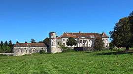 Chateau of Moncley | |
 Émagny Location within Bourgogne-Franche-Comté region  Émagny | |
| Coordinates: 47°18′43″N 5°52′12″E / 47.3119°N 5.87°ECoordinates: 47°18′43″N 5°52′12″E / 47.3119°N 5.87°E | |
| Country | France |
| Region | Bourgogne-Franche-Comté |
| Department | Doubs |
| Arrondissement | Besançon |
| Canton | Saint-Vit |
| Intercommunality | Rives de l'Ognon |
| Government | |
| • Mayor (2008–2014) | Carole Fahy |
| Area1 | 5.15 km2 (1.99 sq mi) |
| Population (2012)2 | 600 |
| • Density | 120/km2 (300/sq mi) |
| Time zone | UTC+1 (CET) |
| • Summer (DST) | UTC+2 (CEST) |
| INSEE/Postal code | 25217 /25170 |
| Elevation |
202–248 m (663–814 ft) (avg. 211 m or 692 ft) |
|
1 French Land Register data, which excludes lakes, ponds, glaciers > 1 km2 (0.386 sq mi or 247 acres) and river estuaries. 2 Population without double counting: residents of multiple communes (e.g., students and military personnel) only counted once. | |
Émagny is a commune in the Doubs department in the Bourgogne-Franche-Comté region in eastern France.
Population
| Historical population | ||
|---|---|---|
| Year | Pop. | ±% |
| 1962 | 333 | — |
| 1968 | 419 | +25.8% |
| 1975 | 411 | −1.9% |
| 1982 | 456 | +10.9% |
| 1990 | 511 | +12.1% |
| 1999 | 563 | +10.2% |
| 2008 | 610 | +8.3% |
| 2012 | 600 | −1.6% |
See also
References
| Wikimedia Commons has media related to Émagny. |
This article is issued from
Wikipedia.
The text is licensed under Creative Commons - Attribution - Sharealike.
Additional terms may apply for the media files.