Allondans
| Allondans | |
|---|---|
| Commune | |
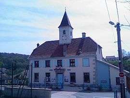 Town hall | |
 Allondans Location within Bourgogne-Franche-Comté region  Allondans | |
| Coordinates: 47°31′12″N 6°44′54″E / 47.52°N 6.7483°ECoordinates: 47°31′12″N 6°44′54″E / 47.52°N 6.7483°E | |
| Country | France |
| Region | Bourgogne-Franche-Comté |
| Department | Doubs |
| Arrondissement | Montbéliard |
| Canton | Bavans |
| Intercommunality | Vallée du Rupt |
| Government | |
| • Mayor (2014-2020) | Agnès Martin |
| Area1 | 5.14 km2 (1.98 sq mi) |
| Population (2014)2 | 239 |
| • Density | 46/km2 (120/sq mi) |
| Time zone | UTC+1 (CET) |
| • Summer (DST) | UTC+2 (CEST) |
| INSEE/Postal code | 25013 /25550 |
| Elevation | 325–435 m (1,066–1,427 ft) |
|
1 French Land Register data, which excludes lakes, ponds, glaciers > 1 km2 (0.386 sq mi or 247 acres) and river estuaries. 2 Population without double counting: residents of multiple communes (e.g., students and military personnel) only counted once. | |
Allondans is a commune in the Doubs department in the Bourgogne-Franche-Comté region in eastern France.
Population
| Historical population | ||
|---|---|---|
| Year | Pop. | ±% |
| 1962 | 184 | — |
| 1968 | 192 | +4.3% |
| 1975 | 187 | −2.6% |
| 1982 | 176 | −5.9% |
| 1990 | 179 | +1.7% |
| 1999 | 191 | +6.7% |
| 2008 | 216 | +13.1% |
| 2012 | 235 | +8.8% |
See also
References
| Wikimedia Commons has media related to Allondans. |
This article is issued from
Wikipedia.
The text is licensed under Creative Commons - Attribution - Sharealike.
Additional terms may apply for the media files.