Villers-sous-Chalamont
| Villers-sous-Chalamont | |
|---|---|
| Commune | |
 | |
 Villers-sous-Chalamont Location within Bourgogne-Franche-Comté region  Villers-sous-Chalamont | |
| Coordinates: 46°54′21″N 6°02′32″E / 46.9058°N 6.0422°ECoordinates: 46°54′21″N 6°02′32″E / 46.9058°N 6.0422°E | |
| Country | France |
| Region | Bourgogne-Franche-Comté |
| Department | Doubs |
| Arrondissement | Pontarlier |
| Canton | Frasne |
| Intercommunality | Altitude 800 |
| Government | |
| • Mayor (2008–2014) | Claude Courtet |
| Area1 | 22.18 km2 (8.56 sq mi) |
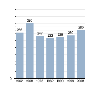
| Population (2008)2 | 280 |
| • Density | 13/km2 (33/sq mi) |
| Time zone | UTC+1 (CET) |
| • Summer (DST) | UTC+2 (CEST) |
| INSEE/Postal code | 25627 /25270 |
| Elevation | 658–901 m (2,159–2,956 ft) |
|
1 French Land Register data, which excludes lakes, ponds, glaciers > 1 km2 (0.386 sq mi or 247 acres) and river estuaries. 2 Population without double counting: residents of multiple communes (e.g., students and military personnel) only counted once. | |
Villers-sous-Chalamont is a commune in the Doubs department in the Bourgogne-Franche-Comté region in eastern France.
Population
See also
References
External links
| Wikimedia Commons has media related to Villers-sous-Chalamont. |
- Commune website (in French)
This article is issued from
Wikipedia.
The text is licensed under Creative Commons - Attribution - Sharealike.
Additional terms may apply for the media files.