Moncley
| Moncley | |
|---|---|
| Commune | |
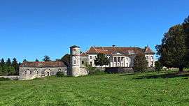 Castle | |
 Moncley Location within Bourgogne-Franche-Comté region  Moncley | |
| Coordinates: 47°18′33″N 5°53′33″E / 47.3092°N 5.8925°ECoordinates: 47°18′33″N 5°53′33″E / 47.3092°N 5.8925°E | |
| Country | France |
| Region | Bourgogne-Franche-Comté |
| Department | Doubs |
| Arrondissement | Besançon |
| Canton | Saint-Vit |
| Intercommunality | Rives de l'Ognon |
| Government | |
| • Mayor (2008–2014) | Patrick Meutelet |
| Area1 | 7.92 km2 (3.06 sq mi) |
| Population (2012)2 | 311 |
| • Density | 39/km2 (100/sq mi) |
| Time zone | UTC+1 (CET) |
| • Summer (DST) | UTC+2 (CEST) |
| INSEE/Postal code | 25383 /25170 |
| Elevation | 204–255 m (669–837 ft) |
|
1 French Land Register data, which excludes lakes, ponds, glaciers > 1 km2 (0.386 sq mi or 247 acres) and river estuaries. 2 Population without double counting: residents of multiple communes (e.g., students and military personnel) only counted once. | |
Moncley is a commune in the Doubs department in the Bourgogne-Franche-Comté region in eastern France.
Geography
Moncley lies 17 km (11 mi) northwest of Besançon in the valley of the Ognon. The river forms the boundary with the department of Haute-Saône.
Population
| Historical population | ||
|---|---|---|
| Year | Pop. | ±% |
| 1962 | 173 | — |
| 1968 | 175 | +1.2% |
| 1975 | 168 | −4.0% |
| 1982 | 231 | +37.5% |
| 1990 | 221 | −4.3% |
| 1999 | 282 | +27.6% |
| 2006 | 333 | +18.1% |
| 2012 | 311 | −6.6% |
See also
References
External links
| Wikimedia Commons has media related to Moncley. |
This article is issued from
Wikipedia.
The text is licensed under Creative Commons - Attribution - Sharealike.
Additional terms may apply for the media files.