Anteuil
| Anteuil | ||
|---|---|---|
| Commune | ||
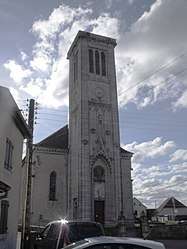 The church in Anteuil | ||
| ||
 Anteuil Location within Bourgogne-Franche-Comté region  Anteuil | ||
| Coordinates: 47°23′18″N 6°33′41″E / 47.3883°N 6.5614°ECoordinates: 47°23′18″N 6°33′41″E / 47.3883°N 6.5614°E | ||
| Country | France | |
| Region | Bourgogne-Franche-Comté | |
| Department | Doubs | |
| Arrondissement | Montbéliard | |
| Canton | Bavans | |
| Government | ||
| • Mayor (2008–2014) | Claude Duquet | |
| Area1 | 24.29 km2 (9.38 sq mi) | |
| Population (2012)2 | 652 | |
| • Density | 27/km2 (70/sq mi) | |
| Time zone | UTC+1 (CET) | |
| • Summer (DST) | UTC+2 (CEST) | |
| INSEE/Postal code | 25018 /25340 | |
| Elevation | 360–836 m (1,181–2,743 ft) | |
|
1 French Land Register data, which excludes lakes, ponds, glaciers > 1 km2 (0.386 sq mi or 247 acres) and river estuaries. 2 Population without double counting: residents of multiple communes (e.g., students and military personnel) only counted once. | ||

Anteuil is a commune in the Doubs department in the Bourgogne-Franche-Comté region in eastern France.
Population
| Historical population | ||
|---|---|---|
| Year | Pop. | ±% |
| 1962 | 391 | — |
| 1968 | 422 | +7.9% |
| 1975 | 385 | −8.8% |
| 1982 | 524 | +36.1% |
| 1990 | 506 | −3.4% |
| 1999 | 482 | −4.7% |
| 2008 | 419 | −13.1% |
| 2012 | 652 | +55.6% |
See also
References
| Wikimedia Commons has media related to Anteuil. |
This article is issued from
Wikipedia.
The text is licensed under Creative Commons - Attribution - Sharealike.
Additional terms may apply for the media files.